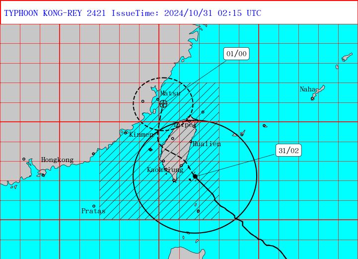
Typhoon Kong-rey is forecast to make landfall in eastern Taiwan this afternoon and would move out to sea sometime overnight, the Central Weather Administration (CWA) said.
As of 9am today, Kong-rey's outer rim was covering most of Taiwan except for the north.
The storm's center was 110km east of Oluanpi (鵝鑾鼻), Taiwan's southernmost tip, and moving northwest at 28kph.

Photo courtesy of the Central Weather Administration
It was carrying maximum sustained winds near its center of 184kph, and gusts of up to 227kph, the CWA said.
At a news conference this morning, CWA forecaster Chu Mei-lin (朱美霖) said Kong-rey is moving "extremely fast," and is expected to make landfall between midday and the afternoon.
The eye of the storm would likely pull away from Taiwan's west coast overnight, followed by its outer rim tomorrow morning, Chu said.
The CWA has forecast extremely heavy rain for eastern and northern Taiwan today, meaning that rainfall totals could exceed 200mm in a 24-hour period or 100mm in three hours.
Mountainous areas in Yilan and Hualien counties in the east could see even higher rainfall levels, Chu said.
In terms of wind, Chu said gusts of up to level 17 on the Beaufort scale (above 200kph) have already been measured on Orchid Island (Lanyu, 蘭嶼), off Taiwan's southeast coast.
As the storm passes over Taiwan, wind speeds are forecast to reach level 14 (149kph to 165kph) in Taitung and Penghu counties, and level 11 (103kph to 117kph) in Hualien, Yilan and Lienchiang counties, as well as areas from New Taipei City to Kaohsiung, Chu said.
Meanwhile, level 9 to 10 wind speeds (75kph to 102kph) are expected in Keelung, Taipei, Nantou County, Chiayi City and Kinmen County, Chu said.
Orchid Island recorded a sustained wind speed of 215.64kph, the CWA said today.
The CWA later this morning said it is not the highest record though the strong wind broke the station’s measuring device.
It is not updating the figure as the weather station on the island is experiencing unstable power supply due to the typhoon, said CWA.

INVESTIGATION: The case is the latest instance of a DPP figure being implicated in an espionage network accused of allegedly leaking information to Chinese intelligence Democratic Progressive Party (DPP) member Ho Jen-chieh (何仁傑) was detained and held incommunicado yesterday on suspicion of spying for China during his tenure as assistant to then-minister of foreign affairs Joseph Wu (吳釗燮). The Taipei District Prosecutors’ Office said Ho was implicated during its investigation into alleged spying activities by former Presidential Office consultant Wu Shang-yu (吳尚雨). Prosecutors said there is reason to believe Ho breached the National Security Act (國家安全法) by leaking classified Ministry of Foreign Affairs information to Chinese intelligence. Following interrogation, prosecutors petitioned the Taipei District Court to detain Ho, citing concerns over potential collusion or tampering of evidence. The

‘FORM OF PROTEST’: The German Institute Taipei said it was ‘shocked’ to see Nazi symbolism used in connection with political aims as it condemned the incident Sung Chien-liang (宋建樑), who led efforts to recall Democratic Progressive Party (DPP) Legislator Lee Kun-cheng (李坤城), was released on bail of NT$80,000 yesterday amid an outcry over a Nazi armband he wore to questioning the night before. Sung arrived at the New Taipei City District Prosecutors’ Office for questioning in a recall petition forgery case on Tuesday night wearing a red armband bearing a swastika, carrying a copy of Adolf Hitler’s Mein Kampf and giving a Nazi salute. Sung left the building at 1:15am without the armband and apparently covering the book with a coat. This is a serious international scandal and Chinese

Seventy percent of middle and elementary schools now conduct English classes entirely in English, the Ministry of Education said, as it encourages schools nationwide to adopt this practice Minister of Education (MOE) Cheng Ying-yao (鄭英耀) is scheduled to present a report on the government’s bilingual education policy to the Legislative Yuan’s Education and Culture Committee today. The report would outline strategies aimed at expanding access to education, reducing regional disparities and improving talent cultivation. Implementation of bilingual education policies has varied across local governments, occasionally drawing public criticism. For example, some schools have required teachers of non-English subjects to pass English proficiency

TRADE: The premier pledged safeguards on ‘Made in Taiwan’ labeling, anti-dumping measures and stricter export controls to strengthen its position in trade talks Products labeled “made in Taiwan” must be genuinely made in Taiwan, Premier Cho Jung-tai (卓榮泰) said yesterday, vowing to enforce strict safeguards against “origin laundering” and initiate anti-dumping investigations to prevent China dumping its products in Taiwan. Cho made the remarks in a discussion session with representatives from industries in Kaohsiung. In response to the US government’s recent announcement of “reciprocal” tariffs on its trading partners, President William Lai (賴清德) and Cho last week began a series of consultations with industry leaders nationwide to gather feedback and address concerns. Taiwanese and US officials held a videoconference on Friday evening to discuss the