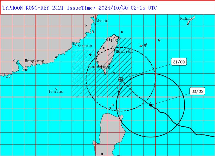
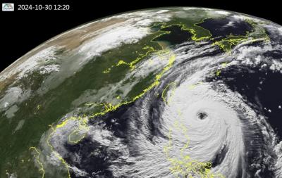
The Central Weather Administration (CWA) issued land warnings for Typhoon Kong-rey this morning as the intensifying storm continued on its path toward the southern tip of Taiwan.
A land warning was issued at 5:30am for Taitung County and the Hengchun Peninsula (恆春), meaning that those areas are expected to be within the storm's outer rim within 18 hours.
At 8:30am, Hualien County and all of Pingtung County were added to the land warning areas.

Photo courtesy of the Central Weather Administration
The storm had intensified into a strong typhoon by 8am, carrying maximum sustained winds near its center of up to 184kph and gusts of 227kph.
By 10am, it was 480km southeast of Oluanpi (鵝鑾鼻), Taiwan's southernmost point, and moving northwest at 15kph to 20kph.
The entirety of Taiwan is expected to be included in the land warning area by late tonight, the CWA said.
The CWA is projecting the storm's periphery to hit southeastern Taiwan early tomorrow morning, and believes the eye is most likely to make landfall south of Hualien County between noon and evening.
The agency predicted heavy rain starting from today for Keelung, the north coast and mountainous areas in greater Taipei and Yilan County, and warned of flash floods, rockfalls and mudslides in the mountains.
Mountainous areas in Yilan may see accumulated rainfall of 250mm to 400mm over the coming 24 hours, the CWA said.
In central and southern Taiwan, rain may only intensify after the storm has made landfall and begun to pass over the Central Mountain Range, the agency said.
The Taipei City Government announced that it would only allow vehicles to exit the riverside areas from 4pm today as it prepares to close the floodgates at 10pm.
Taipei Mayor Chiang Wan-an (蔣萬安) advised residents to secure any loose items, as winds of level 10 on the Beaufort scale (89kph to 102kph) in low-lying areas and level 14 (149kph to 165kph) in mountainous areas are possible tomorrow.
Additional reporting by Tsai Yun-jung

Super Typhoon Kong-rey is the largest cyclone to impact Taiwan in 27 years, the Central Weather Administration (CWA) said today. Kong-rey’s radius of maximum wind (RMW) — the distance between the center of a cyclone and its band of strongest winds — has expanded to 320km, CWA forecaster Chang Chun-yao (張竣堯) said. The last time a typhoon of comparable strength with an RMW larger than 300km made landfall in Taiwan was Typhoon Herb in 1996, he said. Herb made landfall between Keelung and Suao (蘇澳) in Yilan County with an RMW of 350km, Chang said. The weather station in Alishan (阿里山) recorded 1.09m of

STORM’S PATH: Kong-Rey could be the first typhoon to make landfall in Taiwan in November since Gilda in 1967. Taitung-Green Island ferry services have been halted Tropical Storm Kong-rey is forecast to strengthen into a typhoon early today and could make landfall in Taitung County between late Thursday and early Friday, the Central Weather Administration (CWA) said yesterday. As of 2pm yesterday, Kong-Rey was 1,030km east-southeast of Oluanpi (鵝鑾鼻), the nation’s southernmost point, and was moving west at 7kph. The tropical storm was packing maximum sustained winds of 101kph, with gusts of up to 126 kph, CWA data showed. After landing in Taitung, the eye of the storm is forecast to move into the Taiwan Strait through central Taiwan on Friday morning, the agency said. With the storm moving

NO WORK, CLASS: President William Lai urged people in the eastern, southern and northern parts of the country to be on alert, with Typhoon Kong-rey approaching Typhoon Kong-rey is expected to make landfall on Taiwan’s east coast today, with work and classes canceled nationwide. Packing gusts of nearly 300kph, the storm yesterday intensified into a typhoon and was expected to gain even more strength before hitting Taitung County, the US Navy’s Joint Typhoon Warning Center said. The storm is forecast to cross Taiwan’s south, enter the Taiwan Strait and head toward China, the Central Weather Administration (CWA) said. The CWA labeled the storm a “strong typhoon,” the most powerful on its scale. Up to 1.2m of rainfall was expected in mountainous areas of eastern Taiwan and destructive winds are likely

The Central Weather Administration (CWA) yesterday at 5:30pm issued a sea warning for Typhoon Kong-rey as the storm drew closer to the east coast. As of 8pm yesterday, the storm was 670km southeast of Oluanpi (鵝鑾鼻) and traveling northwest at 12kph to 16kph. It was packing maximum sustained winds of 162kph and gusts of up to 198kph, the CWA said. A land warning might be issued this morning for the storm, which is expected to have the strongest impact on Taiwan from tonight to early Friday morning, the agency said. Orchid Island (Lanyu, 蘭嶼) and Green Island (綠島) canceled classes and work