Work and classes have been canceled across the nation today because of Typhoon Krathon, with residents in the south advised to brace for winds that could reach force 17 on the Beaufort scale as the Central Weather Administration (CWA) forecast that the storm would make landfall there.
Force 17 wind with speeds of 56.1 to 61.2 meters per second, the highest number on the Beaufort scale, rarely occur and could cause serious damage.
Krathon could be the second typhoon to land in southwestern Taiwan, following typhoon Elsie in 1996, CWA records showed.

Photo: CNA
As of 8pm yesterday, the typhoon’s center was 180km southwest of Kaohsiung, the agency said.
It was moving northwest at 6kph, with the maximum wind speed near the center reaching 198kph, it said.
The storm’s radius had expanded to 220km, it added.
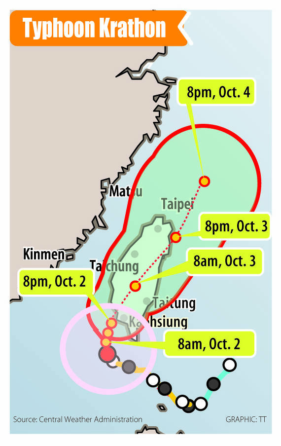
Krathon began moving north yesterday afternoon, but very slowly, CWA senior weather forecaster Wu Wan-hua (伍婉華) said, adding that it is forecast to move northeast after the center makes landfall.
As the typhoon would be affected by Taiwan’s topography after making landfall, Wu said the CWA has lowered its aggregate rainfall estimates for northern and northeastern Taiwan.
It is unlikely that the typhoon and northeast monsoon would converge to jointly affect the weather in the northern region, she added.

Photo: Walid Berrazeg, AFP
The projected path of the typhoon showed it approaching the southwest coast this afternoon, CWA forecaster Lin Ping-yu (林秉煜) said, adding that it could be downgraded to a tropical depression by Friday after making landfall on Taiwan proper.
However, the speed at which Krathon would move after landing has added some uncertainty to the agency’s subsequent forecasts for the typhoon, Lin said.
“It is a typhoon that formed in the fall, which means that it is subject to influences from various atmospheric factors, such as the Pacific high-pressure system and other systems from the north. We will have to monitor whether it would slow down after reaching land on the southwestern coast, and whether it would lean north or south after making landfall,” he said.

Photo: Liao Chen-huei, Taipei Times
Today, extremely heavy to torrential rain is forecast in Kaohsiung and Tainan, as well as in Hualien, Taitung and Pingtung counties, during the day, while chances of heavy rain are high in Yilan and Taipei as well, he said.
If the typhoon makes landfall tonight and proceeds to move northeast, rain in the south is expected to continue steadily while rain in the north would increase, he said.
If the typhoon slows after landing, rainfall in the south is expected to increase, while rain in the north could continue to fall steadily until tomorrow.
All domestic flights today have been canceled, as have numerous international flights.
Tigerair Taiwan announced that round-trip flights between Kaohsiung and Macau; Japan’s Nagoya City, Tokyo Narita Airport and Okinawa Naha Airport; Gimpo International Airport in Seoul; and Da Nang City in Vietnam have been canceled.
EVA Airways (長榮航空) flights departing before midday from Kaohsiung for Tokyo Narita Airport, Osaka City and Hong Kong have also been canceled.
Cathay Pacific Airways canceled round-trip flights between Kaohsiung and Hong Kong, and between Taoyuan and Hong Kong today, tomorrow and on Friday.
Starlux Airlines (星宇航空) yesterday announced that round-trip flights between Taichung and Da Nang and Macau tomorrow have been canceled.
Trains operating on the South Link Railway Line have all been canceled, Taiwan Railway Corp said yesterday, adding that it has adjusted some eastbound and southbound train services.
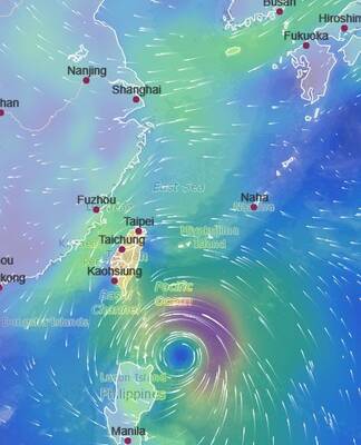
TYPHOON: The storm’s path indicates a high possibility of Krathon making landfall in Pingtung County, depending on when the storm turns north, the CWA said Typhoon Krathon is strengthening and is more likely to make landfall in Taiwan, the Central Weather Administration (CWA) said in a forecast released yesterday afternoon. As of 2pm yesterday, the CWA’s updated sea warning for Krathon showed that the storm was about 430km southeast of Oluanpi (鵝鑾鼻), Taiwan’s southernmost point. It was moving in west-northwest at 9kph, with maximum sustained winds of 119kph and gusts of up to 155kph, CWA data showed. Krathon is expected to move further west before turning north tomorrow, CWA forecaster Wu Wan-hua (伍婉華) said. The CWA’s latest forecast and other countries’ projections of the storm’s path indicate a higher

TYPHOON DAY: Taitung, Pingtung, Tainan, Chiayi, Hualien and Kaohsiung canceled work and classes today. The storm is to start moving north this afternoon The outer rim of Typhoon Krathon made landfall in Taitung County and the Hengchun Peninsula (恆春半島) at about noon yesterday, the Central Weather Administration (CWA) said, adding that the eye of the storm was expected to hit land tomorrow. The CWA at 2:30pm yesterday issued a land alert for Krathon after issuing a sea alert on Sunday. It also expanded the scope of the sea alert to include waters north of Taiwan Strait, in addition to its south, from the Bashi Channel to the Pratas Islands (Dongsha Islands, 東沙群島). As of 6pm yesterday, the typhoon’s center was 160km south of

SECURITY: The New Zealand and Australian navies also sailed military vessels through the Strait yesterday to assert the right of freedom of navigation The Japan Maritime Self-Defense Force on Wednesday made its first-ever transit through the Taiwan Strait in response to the intrusion by a Chinese reconnaissance aircraft into Japan’s sovereign airspace last month, Yomiuri Shimbun reported yesterday. The Japanese news platform reported that the destroyer JS Sazanamisailed down through the Taiwan Strait on Wednesday, citing sources in the Japanese government with knowledge of the matter. Japanese Chief Cabinet Secretary Yoshimasa Hayashi declined to comment on the reports at a regular briefing because they concern military operations. Military vessels from New Zealand and Australia also sailed through the Strait on the same day, Wellington’s defense ministry
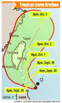
The Central Weather Administration (CWA) is set to issue sea and land warnings for Tropical Storm Krathon as projections showed that the tropical storm could strengthen into a typhoon as it approaches Taiwan proper, the CWA said yesterday. The sea warning is scheduled to take effect this morning and the land warning this evening, it said. The storm formed yesterday morning and in the evening reached a point 620 nautical miles (1,148km) southeast of Oluanpi (鵝鑾鼻), Taiwan proper’s southernmost point, moving west-southwest at 4 kph as it strengthened, the CWA said. Its radius measured between 220km and 250km, it added. Krathon is projected