Blistering heat that has baked swathes of North America and Europe this month would have been “virtually impossible” without human-caused climate change, researchers said yesterday, as intense temperatures spark health alerts and stoke ferocious wildfires.
With tens of million people affected in the northern hemisphere and this month on track to be the hottest month globally since records began, experts warned that worse is to come unless we reduce planet-heating emissions. Severe heat waves have gripped southern Europe, parts of the US, Mexico and China this month, with temperatures above 45oC.
In the new rapid analysis of the scorching temperatures, scientists from the World Weather Attribution (WWA) group found that the heat waves in parts of Europe and North America would have been almost impossible without climate change.

Photo: AP
Temperatures in China were made 50 times more likely by global warming, they found.
“The role of climate change is absolutely overwhelming,” said climate scientist Friederike Otto, of the Grantham Institute for Climate Change and the Environment at Imperial College London.
Intense temperatures have swept much of the southwest and southern US, including in Phoenix, Arizona, which saw a record-breaking three straight weeks of highs above 43oC.

Photo: AP
Blazes on the Greek mainland and islands have caused tens of thousands to flee, sent tourists scrambling for evacuation flights and prompted the prime minister to say the country is “at war.”
In Beijing, the government urged elderly people to stay indoors and children to shorten outdoor playtime to reduce exposure to the heat and ground-level ozone pollution.
Scientists have already established that climate change — with about 1.2oC of global warming since the late 1800s — has made heat waves in general hotter, longer and more frequent. To trace how far this month’s heat waves in the northern hemisphere had departed from what would have been expected without that warming, Otto and her WWA colleagues used weather data and computer model simulations to compare the climate as it is today with that of the past.
Researchers said they focused on periods when “the heat was most dangerous in each region.”
Otto said that in the past it would have been “basically impossible” that such severe heat waves would happen at the same time, and that people should no longer be surprised to see temperature records tumbling.
“As long as we keep burning fossil fuels we will see more and more of these extremes,” she said.
The researchers found that these severe heat waves can now be expected roughly once every 15 years in North America, every 10 years in southern Europe and every five years in China. They would also become even more frequent — happening every two to five years — if temperature rise reaches 2oC, which is expected in about 30 years unless countries fulfil their Paris Agreement pledges and rapidly cut emissions.

AIR SUPPORT: The Ministry of National Defense thanked the US for the delivery, adding that it was an indicator of the White House’s commitment to the Taiwan Relations Act Deputy Minister of National Defense Po Horng-huei (柏鴻輝) and Representative to the US Alexander Yui on Friday attended a delivery ceremony for the first of Taiwan’s long-awaited 66 F-16C/D Block 70 jets at a Lockheed Martin Corp factory in Greenville, South Carolina. “We are so proud to be the global home of the F-16 and to support Taiwan’s air defense capabilities,” US Representative William Timmons wrote on X, alongside a photograph of Taiwanese and US officials at the event. The F-16C/D Block 70 jets Taiwan ordered have the same capabilities as aircraft that had been upgraded to F-16Vs. The batch of Lockheed Martin

GRIDLOCK: The National Fire Agency’s Special Search and Rescue team is on standby to travel to the countries to help out with the rescue effort A powerful earthquake rocked Myanmar and neighboring Thailand yesterday, killing at least three people in Bangkok and burying dozens when a high-rise building under construction collapsed. Footage shared on social media from Myanmar’s second-largest city showed widespread destruction, raising fears that many were trapped under the rubble or killed. The magnitude 7.7 earthquake, with an epicenter near Mandalay in Myanmar, struck at midday and was followed by a strong magnitude 6.4 aftershock. The extent of death, injury and destruction — especially in Myanmar, which is embroiled in a civil war and where information is tightly controlled at the best of times —

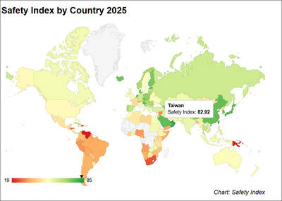
Taiwan was ranked the fourth-safest country in the world with a score of 82.9, trailing only Andorra, the United Arab Emirates and Qatar in Numbeo’s Safety Index by Country report. Taiwan’s score improved by 0.1 points compared with last year’s mid-year report, which had Taiwan fourth with a score of 82.8. However, both scores were lower than in last year’s first review, when Taiwan scored 83.3, and are a long way from when Taiwan was named the second-safest country in the world in 2021, scoring 84.8. Taiwan ranked higher than Singapore in ninth with a score of 77.4 and Japan in 10th with

SECURITY RISK: If there is a conflict between China and Taiwan, ‘there would likely be significant consequences to global economic and security interests,’ it said China remains the top military and cyber threat to the US and continues to make progress on capabilities to seize Taiwan, a report by US intelligence agencies said on Tuesday. The report provides an overview of the “collective insights” of top US intelligence agencies about the security threats to the US posed by foreign nations and criminal organizations. In its Annual Threat Assessment, the agencies divided threats facing the US into two broad categories, “nonstate transnational criminals and terrorists” and “major state actors,” with China, Russia, Iran and North Korea named. Of those countries, “China presents the most comprehensive and robust military threat