The Central Weather Bureau yesterday said it has not ruled out that Tropical Storm Doksuri could make landfall in Taiwan, although considerable uncertainty remains about its path.
As of 8pm, Doksuri was about 1,300km southeast of Oluanpi (鵝鑾鼻), Taiwan’s southernmost point, moving west at 9kph, bureau data showed.
The storm, which had a radius of 100km, was packing maximum sustained winds of 82kph with gusts of up to 108kph.

Doksuri could get stronger after today and turn northwest tomorrow when it reaches the Philippine Sea, but its effect on Taiwan would depend on how much it changes direction, bureau forecaster Lin Ting-yi (林定宜) said.
The most likely day on which a sea warning might be issued would be Tuesday, he added.
Doksuri’s periphery would affect Taiwan from that day, when the north and east of the country would have rain.

Photo courtesy of the Kaohsiung Harbor Bureau
Doksuri would be closest to Taiwan on Wednesday and Thursday, and during those two days, there would be rain across all of Taiwan, he said.
Meanwhile, work continued yesterday on the recovery of about 600 containers that fell into the ocean after the Palau-flagged ship Angel sank on Friday while anchored off the Port of Kaohsiung, Taiwan International Ports Corp’s Kaohsiung branch said.
The company said it is working with the Kaohsiung City Government, the Coast Guard Administration, the Kaohsiung Harbor Bureau and the Fisheries Agency.
It said that 17 vessels were yesterday sent to retrieve the containers, many of which have been seen floating near Linyuan District (林園) and Donggang Township (東港).
Although it could take four to five days to recover all of the containers, progress would depend largely on marine conditions, the company said.
As of noon yesterday only 26 containers had been retrieved, and there were reports of others getting in the way of local fishing boats and damaging fishing equipment.
Taiwan International Ports Corp said a salvage team would be sent to the ship today to seal the vents connected to its oil tanks and pump the oil out to avoid any leakage.
The ship reportedly contains 393.4 tonnes of low-sulfur fuel, 98.1 tonnes of light diesel and 0.348 tonnes of lubricating oil.
The Angel, which was anchored about 5km from shore on July 4, began taking on water and listing on Thursday, before the captain decided to abandon ship and ordered all 19 crew into lifeboats.
The ship sank at about midnight the next day.
SECURITY: As China is ‘reshaping’ Hong Kong’s population, Taiwan must raise the eligibility threshold for applications from Hong Kongers, Chiu Chui-cheng said When Hong Kong and Macau citizens apply for residency in Taiwan, it would be under a new category that includes a “national security observation period,” Mainland Affairs Council (MAC) Minister Chiu Chui-cheng (邱垂正) said yesterday. President William Lai (賴清德) on March 13 announced 17 strategies to counter China’s aggression toward Taiwan, including incorporating national security considerations into the review process for residency applications from Hong Kong and Macau citizens. The situation in Hong Kong is constantly changing, Chiu said to media yesterday on the sidelines of the Taipei Technology Run hosted by the Taipei Neihu Technology Park Development Association. With

CARROT AND STICK: While unrelenting in its military threats, China attracted nearly 40,000 Taiwanese to over 400 business events last year Nearly 40,000 Taiwanese last year joined industry events in China, such as conferences and trade fairs, supported by the Chinese government, a study showed yesterday, as Beijing ramps up a charm offensive toward Taipei alongside military pressure. China has long taken a carrot-and-stick approach to Taiwan, threatening it with the prospect of military action while reaching out to those it believes are amenable to Beijing’s point of view. Taiwanese security officials are wary of what they see as Beijing’s influence campaigns to sway public opinion after Taipei and Beijing gradually resumed travel links halted by the COVID-19 pandemic, but the scale of
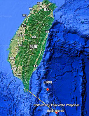
A US Marine Corps regiment equipped with Naval Strike Missiles (NSM) is set to participate in the upcoming Balikatan 25 exercise in the Luzon Strait, marking the system’s first-ever deployment in the Philippines. US and Philippine officials have separately confirmed that the Navy Marine Expeditionary Ship Interdiction System (NMESIS) — the mobile launch platform for the Naval Strike Missile — would take part in the joint exercise. The missiles are being deployed to “a strategic first island chain chokepoint” in the waters between Taiwan proper and the Philippines, US-based Naval News reported. “The Luzon Strait and Bashi Channel represent a critical access

Pope Francis is be laid to rest on Saturday after lying in state for three days in St Peter’s Basilica, where the faithful are expected to flock to pay their respects to history’s first Latin American pontiff. The cardinals met yesterday in the Vatican’s synod hall to chart the next steps before a conclave begins to choose Francis’ successor, as condolences poured in from around the world. According to current norms, the conclave must begin between May 5 and 10. The cardinals set the funeral for Saturday at 10am in St Peter’s Square, to be celebrated by the dean of the College