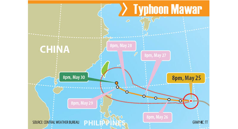
The Central Weather Bureau could issue a sea alert for Super Typhoon Mawar, as it is forecast to turn north and come closest to Taiwan from Tuesday to Wednesday next week.
Mawar was downgraded from a super typhoon to a typhoon after sweeping across Guam on Wednesday night, knocking down trees and leaving much of the US territory without power.
Many residents of Guam yesterday remained without power and utilities after Mawar tore through the remote US Pacific territory the previous night, ripping roofs off homes, flipping vehicles and shredding trees.
There were no immediate reports of deaths and injuries, but the central and northern parts of the island received more than 60cm of rain as the eyewall passed.
Mawar regained strength after leaving Guam and was upgraded to a super typhoon at 8am yesterday.
As of 2pm yesterday, Mawar was 2,490km southeast of Oluanbi (鵝鑾鼻), moving west at 23kph, bureau data showed.
The maximum speed reached 198kph, with the storm’s radius expanding to 250km, the bureau said.
The bureau forecast that the typhoon could start turning north on Monday or Tuesday next week, adding that it could come closest to Taiwan on Tuesday or Wednesday.
Whether a sea alert would be issued for Mawar would depend on the angle at which it turns north when it enters the Bashi Channel, it said.
Although the chances of landfall are low, people should beware of torrential rainfall brought by the typhoon’s outer bands, the bureau said.
From Monday to Thursday next week, chances of temporary showers are to be high along the north and east coasts, Taipei, New Taipei City, Keelung and the Hengchun Peninsula, it said.
Cloudy to sunny skies are forecast for the rest of the nation, while afternoon thundershowers are forecast for mountainous areas, the bureau said.
As Mawar is forecast to gradually affect the east coast, the Port and Maritime Bureau last night announced that ferries connecting Taiwan proper with Orchid Island (Lanyu, 蘭嶼) and Green Island (綠島) would be suspended from tomorrow until Tuesday next week.
People traveling to Orchid Island and Green Island should pay attention to weather information and the status of shipping services, and make plans in advance to avoid being stranded on the two outlying islands, the bureau said.
Additional reporting by AP
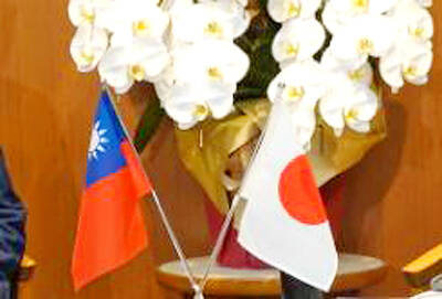
‘CORRECT IDENTIFICATION’: Beginning in May, Taiwanese married to Japanese can register their home country as Taiwan in their spouse’s family record, ‘Nikkei Asia’ said The government yesterday thanked Japan for revising rules that would allow Taiwanese nationals married to Japanese citizens to list their home country as “Taiwan” in the official family record database. At present, Taiwanese have to select “China.” Minister of Foreign Affairs Lin Chia-lung (林佳龍) said the new rule, set to be implemented in May, would now “correctly” identify Taiwanese in Japan and help protect their rights, the Ministry of Foreign Affairs said in a statement. The statement was released after Nikkei Asia reported the new policy earlier yesterday. The name and nationality of a non-Japanese person marrying a Japanese national is added to the
AT RISK: The council reiterated that people should seriously consider the necessity of visiting China, after Beijing passed 22 guidelines to punish ‘die-hard’ separatists The Mainland Affairs Council (MAC) has since Jan. 1 last year received 65 petitions regarding Taiwanese who were interrogated or detained in China, MAC Minister Chiu Chui-cheng (邱垂正) said yesterday. Fifty-two either went missing or had their personal freedoms restricted, with some put in criminal detention, while 13 were interrogated and temporarily detained, he said in a radio interview. On June 21 last year, China announced 22 guidelines to punish “die-hard Taiwanese independence separatists,” allowing Chinese courts to try people in absentia. The guidelines are uncivilized and inhumane, allowing Beijing to seize assets and issue the death penalty, with no regard for potential

‘UNITED FRONT’ FRONTS: Barring contact with Huaqiao and Jinan universities is needed to stop China targeting Taiwanese students, the education minister said Taiwan has blacklisted two Chinese universities from conducting academic exchange programs in the nation after reports that the institutes are arms of Beijing’s United Front Work Department, Minister of Education Cheng Ying-yao (鄭英耀) said in an exclusive interview with the Chinese-language Liberty Times (the Taipei Times’ sister paper) published yesterday. China’s Huaqiao University in Xiamen and Quanzhou, as well as Jinan University in Guangzhou, which have 600 and 1,500 Taiwanese on their rolls respectively, are under direct control of the Chinese government’s political warfare branch, Cheng said, citing reports by national security officials. A comprehensive ban on Taiwanese institutions collaborating or

STILL COMMITTED: The US opposes any forced change to the ‘status quo’ in the Strait, but also does not seek conflict, US Secretary of State Marco Rubio said US President Donald Trump’s administration released US$5.3 billion in previously frozen foreign aid, including US$870 million in security exemptions for programs in Taiwan, a list of exemptions reviewed by Reuters showed. Trump ordered a 90-day pause on foreign aid shortly after taking office on Jan. 20, halting funding for everything from programs that fight starvation and deadly diseases to providing shelters for millions of displaced people across the globe. US Secretary of State Marco Rubio, who has said that all foreign assistance must align with Trump’s “America First” priorities, issued waivers late last month on military aid to Israel and Egypt, the