The Central Weather Bureau yesterday issued a sea warning for Typhoon Muifa, saying that the storm could bring showers to northern and northeastern Taiwan.
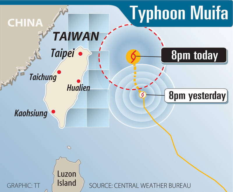
The typhoon was 340km east of Taipei at 8pm yesterday. It was moving north at 7kph, packing sustained winds of 155kph with gusts of up to 191kph. It had a radius of 150km.
The storm is forecast to slow down today and tomorrow, when it is expected to come closest to Taiwan, before moving away on Wednesday, bureau meteorologist Wu Wan-hua (伍婉華) said.
The bureau warned of high waves off Keelung, as well as the north and east coast, including Green Island (綠島) and Orchid Island (Lanyu, 蘭嶼). The warning also covered waters around the Hengchun Peninsula (恆春半島) and the outlying Lienchiang County.
Until tomorrow, the periphery of Muifa would bring heavy rain to mountainous areas in northern and northeastern Taiwan, and the northern coastal areas, including Keelung, while there is also a chance of afternoon showers in the east and southeast, the bureau said.
The rain would likely ease by Wednesday, it said.

Photo: CNA
Due to the approaching storm, ferry operators between Green Island and Taitung County’s Fugang Fishery Harbor transported an estimated 5,000 people to the county yesterday morning before suspending services in the afternoon.
The Maritime and Port Bureau said that almost all ferries from Taiwan proper to outlying islands would be canceled today.
Officials said the Shihmen Reservoir (石門水庫) in Taoyuan is discharging water at a low rate as a precaution against possible flooding due to the typhoon.
It urged people to avoid downstream areas of the reservoir.
As of 10am yesterday, the water level at the reservoir was 244.85m, close to its 245m capacity.

Tropical Storm Gaemi strengthened into a typhoon at 2pm yesterday, and could make landfall in Yilan County tomorrow, the Central Weather Administration (CWA) said yesterday. The agency was scheduled to issue a sea warning at 11:30pm yesterday, and could issue a land warning later today. Gaemi was moving north-northwest at 4kph, carrying maximum sustained winds near its center of up to 118.8kph and gusts of 154.8kph. The circumference is forecast to reach eastern Taiwan tomorrow morning, with the center making landfall in Yilan County later that night before departing from the north coast, CWA weather forecaster Kuan Shin-ping (官欣平) said yesterday. Uncertainty remains and

SEA WARNING LIKELY: The storm, named Gaemi, could become a moderate typhoon on Wednesday or Thursday, with the Taipei City Government preparing for flooding A tropical depression east of the Philippines developed into a tropical storm named Gaemi at 2pm yesterday, and was moving toward eastern Taiwan, the Central Weather Administration (CWA) said. Gaemi could begin to affect Taiwan proper on Tuesday, lasting until Friday, and could develop into a moderate typhoon on Wednesday or Thursday, it said. A sea warning for Gaemi could be issued as early as Tuesday morning, it added. Gaemi, the third tropical storm in the Pacific Ocean this typhoon season, is projected to begin moving northwest today, and be closest to Taiwan on Wednesday or Thursday, the agency said. Today, there would likely

DISRUPTIONS: The high-speed rail is to operate as normal, while several airlines either canceled flights or announced early departures or late arrivals Schools and offices in 15 cities and counties are to be closed today due to Typhoon Gaemi, local governments announced last night. The 15 are: Taipei, New Taipei City, Taoyuan, Tainan, Keelung, Hsinchu and Kaohsiung, as well as Yilan, Hualien, Hsinchu, Miaoli, Chiayi, Pingtung, Penghu and Lienchiang counties. People should brace for torrential rainfall brought by the storm, with its center forecast to make landfall on the east coast between tonight and tomorrow morning, the Central Weather Administration (CWA) said. The agency issued a sea warning for the typhoon at 11:30pm on Monday, followed by a land warning at 11:30am yesterday. As of

CASUALTY: A 70-year-old woman was killed by a falling tree in Kaohsiung as the premier warned all government agencies to remain on high alert for the next 24 hours Schools and offices nationwide are to be closed for a second day today as Typhoon Gaemi crosses over the nation, bringing torrential rain and whipping winds. Gaemi was forecast to make landfall late last night. From Tuesday night, its outer band brought substantial rainfall and strong winds to the nation. As of 6:15pm last night, the typhoon’s center was 20km southeast of Hualien County, Central Weather Administration (CWA) data showed. It was moving at 19kph and had a radius of 250km. As of 3pm yesterday, one woman had died, while 58 people were injured, the Central Emergency Operation Center said. The 70-year-old