Efforts to draft an ambitious global agreement on halting nature loss ended on Sunday with little progress made in the Nairobi negotiations, leaving limited time for brokering a biodiversity pact this year.
About 1,000 negotiators from 150 countries were supposed to finalize a new draft agreement on protecting nature and wildlife, which would then be considered for adoption at the COP15 biodiversity summit in Montreal, Canada, in December.
However, by Sunday’s closing, the delegations had agreed on the wording of only two of more than 20 goals, with much of the draft document still riddled with brackets — signaling a lack of consensus.

Photo: AFP
“There is a significant amount of work in front of us … a lot more than what we thought,” said meeting cochair Basile van Havre of the Canadian Ministry of Environment and Climate Change.
Some environmental groups said they thought some delegations were becoming less ambitious from meeting to meeting.
“Previous proposals have [since] been weakened; commitments are being made more vague and pushed down the road to 2050 instead of 2030,” said Guido Broekhoven, head of policy at World Wildlife Fund International.
For example, parties were still debating whether the agreement should address pesticide use.
Meanwhile, delegates had removed all mention of infrastructure, such as roads, threatening wildlife, Broekhoven said.
Observers worried that the lack of progress in Nairobi would spell failure in Montreal.
“We cannot afford to fail,” said Elizabeth Maruma Mrema, executive secretary of the UN Convention on Biological Diversity.
Organizers said they would seek to schedule yet another round of talks before the Montreal summit.
The Nairobi talks had been organized quickly, after March talks in Geneva, Switzerland, failed to make much progress on the draft.
The decision to hold COP15 in Montreal was announced last week, after the Chinese hosts postponed the summit four times due to the COVID-19 pandemic.
While China will continue to hold the summit presidency, some observers said they hoped the change of venue would boost opportunities for public engagement, and participation by civil society and nonprofit groups.
For example, China does not allow for mass demonstrations.
“You would expect that there are going to be mobilizations from different groups, in particular indigenous peoples,” said Eddy Perez of the nonprofit Climate Action Network in Montreal.

A car bomb killed a senior Russian general in southern Moscow yesterday morning, the latest high-profile army figure to be blown up in a blast that came just hours after Russian and Ukrainian delegates held separate talks in Miami on a plan to end the war. Kyiv has not commented on the incident, but Russian investigators said they were probing whether the blast was “linked” to “Ukrainian special forces.” The attack was similar to other assassinations of generals and pro-war figures that have either been claimed, or are widely believed to have been orchestrated, by Ukraine. Russian Lieutenant General Fanil Sarvarov, 56, head

SAFETY FIRST: Double the number of police were deployed at the Taipei Marathon, while other cities released plans to bolster public event safety Authorities across Taiwan have stepped up security measures ahead of Christmas and New Year events, following a knife and smoke bomb attack in Taipei on Friday that left four people dead and 11 injured. In a bid to prevent potential copycat incidents, police deployments have been expanded for large gatherings, transport hubs, and other crowded public spaces, according to official statements from police and city authorities. Taipei Mayor Chiang Wan-an (蔣萬安) said the city has “comprehensively raised security readiness” in crowded areas, increased police deployments with armed officers, and intensified patrols during weekends and nighttime hours. For large-scale events, security checkpoints and explosives

‘POLITICAL GAME’: DPP lawmakers said the motion would not meet the legislative threshold needed, and accused the KMT and the TPP of trivializing the Constitution The Legislative Yuan yesterday approved a motion to initiate impeachment proceedings against President William Lai (賴清德), saying he had undermined Taiwan’s constitutional order and democracy. The motion was approved 61-50 by lawmakers from the main opposition Chinese Nationalist Party (KMT) and the smaller Taiwan People’s Party (TPP), who together hold a legislative majority. Under the motion, a roll call vote for impeachment would be held on May 19 next year, after various hearings are held and Lai is given the chance to defend himself. The move came after Lai on Monday last week did not promulgate an amendment passed by the legislature that

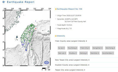
A magnitude 7.0 earthquake struck off Yilan at 11:05pm yesterday, the Central Weather Administration (CWA) said. The epicenter was located at sea, about 32.3km east of Yilan County Hall, at a depth of 72.8km, CWA data showed There were no immediate reports of damage. The intensity of the quake, which gauges the actual effect of a seismic event, measured 4 in Yilan County area on Taiwan’s seven-tier intensity scale, the data showed. It measured 4 in other parts of eastern, northern and central Taiwan as well as Tainan, and 3 in Kaohsiung and Pingtung County, and 2 in Lienchiang and Penghu counties and 1