The Central Epidemic Command Center (CECC) yesterday urged people to continue practicing personal preventive measures against COVID-19 after large crowds gathered at tourist attractions on the first two days of the four-day Mid-Autumn Festival long weekend, raising concerns over the risk of infection.
It is the first long weekend since a nationwide COVID-19 alert was downgraded to level 2, and images of scenic spots crowded with visitors were posted to Facebook and reported by local media.
An image posted to a Facebook group showed visitors packed along a stretch of boardwalk in the Gaomei Wetlands (高美濕地) in Taichung on Sunday.
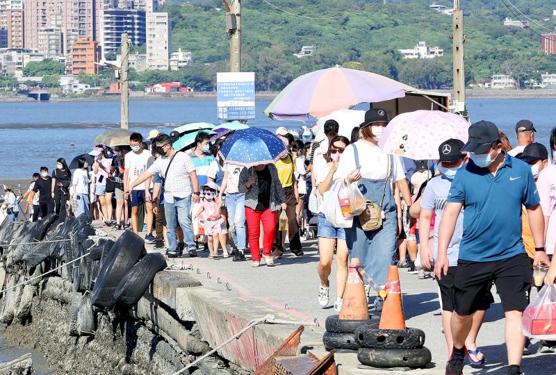
Photo: CNA
The local police department estimated that about 3,500 visitors and about 1,200 vehicles were in the area that day, local Chinese-language media reported.
The Taichung Agriculture Bureau yesterday said that only up to 691 visitors are normally allowed on the boardwalk during a level 2 alert, but visitors began flooding the trail from about 4pm and an electronic people counter malfunctioned.
Crowd control in the scenic area was conducted manually yesterday and the police department dispatched officers to help control the flow of visitors, the bureau said.
The self-management committee of Kenting Main Street (墾丁大街) in Pingtung County reported that the street, known for its night market, was visited by at least 8,000 people each night during the first two days of the holiday.
The Pingtung County Government yesterday said it has asked the local police department and the committee to start implementing crowd control measures earlier, from 6:30pm, and to have more personnel reminding visitors to practice personal preventive measures.
Asked about the issue, Minister of Health and Welfare Chen Shih-chung (陳時中), who heads the center, yesterday said: “Of course, everyone is inevitably worried about the crowded scenes.”
He said COVID-19 restrictions are being gradually eased and newly reported cases are still considered under control, adding that the crowded scenes are part of the process of society returning to normal.
“However, we still urge people to wear a mask at all times, practice social distancing and frequently wash their hands,” Chen added.
Additional reporting by CNA
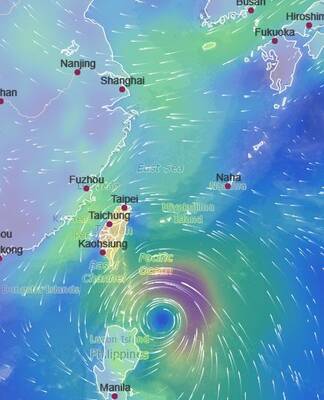
TYPHOON: The storm’s path indicates a high possibility of Krathon making landfall in Pingtung County, depending on when the storm turns north, the CWA said Typhoon Krathon is strengthening and is more likely to make landfall in Taiwan, the Central Weather Administration (CWA) said in a forecast released yesterday afternoon. As of 2pm yesterday, the CWA’s updated sea warning for Krathon showed that the storm was about 430km southeast of Oluanpi (鵝鑾鼻), Taiwan’s southernmost point. It was moving in west-northwest at 9kph, with maximum sustained winds of 119kph and gusts of up to 155kph, CWA data showed. Krathon is expected to move further west before turning north tomorrow, CWA forecaster Wu Wan-hua (伍婉華) said. The CWA’s latest forecast and other countries’ projections of the storm’s path indicate a higher

SLOW-MOVING STORM: The typhoon has started moving north, but at a very slow pace, adding uncertainty to the extent of its impact on the nation Work and classes have been canceled across the nation today because of Typhoon Krathon, with residents in the south advised to brace for winds that could reach force 17 on the Beaufort scale as the Central Weather Administration (CWA) forecast that the storm would make landfall there. Force 17 wind with speeds of 56.1 to 61.2 meters per second, the highest number on the Beaufort scale, rarely occur and could cause serious damage. Krathon could be the second typhoon to land in southwestern Taiwan, following typhoon Elsie in 1996, CWA records showed. As of 8pm yesterday, the typhoon’s center was 180km

TYPHOON DAY: Taitung, Pingtung, Tainan, Chiayi, Hualien and Kaohsiung canceled work and classes today. The storm is to start moving north this afternoon The outer rim of Typhoon Krathon made landfall in Taitung County and the Hengchun Peninsula (恆春半島) at about noon yesterday, the Central Weather Administration (CWA) said, adding that the eye of the storm was expected to hit land tomorrow. The CWA at 2:30pm yesterday issued a land alert for Krathon after issuing a sea alert on Sunday. It also expanded the scope of the sea alert to include waters north of Taiwan Strait, in addition to its south, from the Bashi Channel to the Pratas Islands (Dongsha Islands, 東沙群島). As of 6pm yesterday, the typhoon’s center was 160km south of
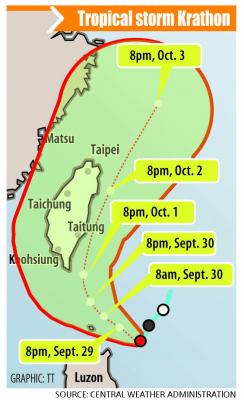
The Central Weather Administration (CWA) is set to issue sea and land warnings for Tropical Storm Krathon as projections showed that the tropical storm could strengthen into a typhoon as it approaches Taiwan proper, the CWA said yesterday. The sea warning is scheduled to take effect this morning and the land warning this evening, it said. The storm formed yesterday morning and in the evening reached a point 620 nautical miles (1,148km) southeast of Oluanpi (鵝鑾鼻), Taiwan proper’s southernmost point, moving west-southwest at 4 kph as it strengthened, the CWA said. Its radius measured between 220km and 250km, it added. Krathon is projected