US Secretary of State Antony Blinken on Sunday said that the US is concerned about China’s aggressive actions against Taiwan and remains committed to ensuring Taiwan “has the ability to defend itself.”
“What we’ve seen, and what is of real concern to us, is increasingly aggressive actions by the government in Beijing directed at Taiwan, raising tensions in the straits,” Blinken said in an interview with NBC’s Meet the Press.
He said Washington has a longstanding bipartisan commitment to Taipei under the Taiwan Relations Act to ensure Taiwan “has the ability to defend itself,” and to make sure the US is sustaining peace and security in the western Pacific.

Photo: CNA
“We stand behind those commitments,” he said.
However, Blinken refused to comment on a hypothetical situation when asked if the US would respond militarily to a potential Chinese attack on Taiwan.
Meanwhile, former US secretary of state Mike Pompeo yesterday posted a photograph of himself eating Taiwanese dried pineapple on Twitter, his latest public declaration of support for Taiwan.
The Ministry of Foreign Affairs last month said that it had not yet discussed the possibility of Pompeo visiting Taiwan.
However, when asked yesterday by Democratic Progressive Party Legislator Wang Ting-yu (王定宇) about the possibility of a visit to Taiwan by Pompeo some time this year, Deputy Minister of Foreign Affairs Tien Chung-kwang (田中光) nodded and said that the ministry “is working on it.”
Additional reporting by Lu Yi-hsuan

AIR SUPPORT: The Ministry of National Defense thanked the US for the delivery, adding that it was an indicator of the White House’s commitment to the Taiwan Relations Act Deputy Minister of National Defense Po Horng-huei (柏鴻輝) and Representative to the US Alexander Yui on Friday attended a delivery ceremony for the first of Taiwan’s long-awaited 66 F-16C/D Block 70 jets at a Lockheed Martin Corp factory in Greenville, South Carolina. “We are so proud to be the global home of the F-16 and to support Taiwan’s air defense capabilities,” US Representative William Timmons wrote on X, alongside a photograph of Taiwanese and US officials at the event. The F-16C/D Block 70 jets Taiwan ordered have the same capabilities as aircraft that had been upgraded to F-16Vs. The batch of Lockheed Martin

GRIDLOCK: The National Fire Agency’s Special Search and Rescue team is on standby to travel to the countries to help out with the rescue effort A powerful earthquake rocked Myanmar and neighboring Thailand yesterday, killing at least three people in Bangkok and burying dozens when a high-rise building under construction collapsed. Footage shared on social media from Myanmar’s second-largest city showed widespread destruction, raising fears that many were trapped under the rubble or killed. The magnitude 7.7 earthquake, with an epicenter near Mandalay in Myanmar, struck at midday and was followed by a strong magnitude 6.4 aftershock. The extent of death, injury and destruction — especially in Myanmar, which is embroiled in a civil war and where information is tightly controlled at the best of times —

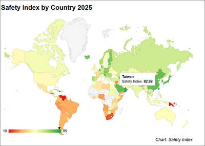
Taiwan was ranked the fourth-safest country in the world with a score of 82.9, trailing only Andorra, the United Arab Emirates and Qatar in Numbeo’s Safety Index by Country report. Taiwan’s score improved by 0.1 points compared with last year’s mid-year report, which had Taiwan fourth with a score of 82.8. However, both scores were lower than in last year’s first review, when Taiwan scored 83.3, and are a long way from when Taiwan was named the second-safest country in the world in 2021, scoring 84.8. Taiwan ranked higher than Singapore in ninth with a score of 77.4 and Japan in 10th with

China's military today said it began joint army, navy and rocket force exercises around Taiwan to "serve as a stern warning and powerful deterrent against Taiwanese independence," calling President William Lai (賴清德) a "parasite." The exercises come after Lai called Beijing a "foreign hostile force" last month. More than 10 Chinese military ships approached close to Taiwan's 24 nautical mile (44.4km) contiguous zone this morning and Taiwan sent its own warships to respond, two senior Taiwanese officials said. Taiwan has not yet detected any live fire by the Chinese military so far, one of the officials said. The drills took place after US Secretary