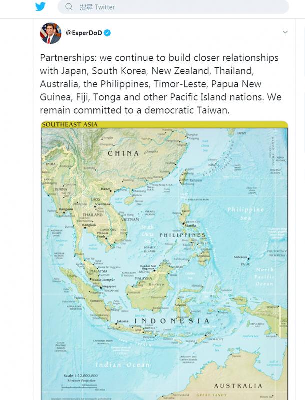
US Secretary of Defense Mark Esper yesterday wrote on Twitter that the US remains “committed to a democratic Taiwan.”
“Partnerships: we continue to build closer relationships with Japan, South Korea, New Zealand, Thailand, Australia, the Philippines, Timor-Leste, Papua New Guinea, Fiji, Tonga and other Pacific Island nations. We remain committed to a democratic Taiwan,” he wrote, while sharing a map of Southeast Asia.
The tweet followed one from an hour earlier, which said: “As an Indo-Pacific nation, the #USA is investing in preparedness, strengthening partnerships, and promoting a more networked region.”

Photo: screen grab from Twitter
The US and China have been increasing military patrols in the region as bilateral tensions spike.
The Associated Press on Friday reported that three US Navy aircraft carriers were patrolling the Indo-Pacific for the first time in nearly three years.
China’s South China Sea Strategic Situation Probing Initiative yesterday on Twitter wrote that two US Air Force KC-135 Stratotankers were detected in the East China and South China seas near Taiwan’s airspace.
An image shared by the initiative showed that one of the tankers had departed from Okinawa, while the other was only identified as flying over the Bashi Channel.
A Chinese J-10 fighter was yesterday morning detected briefly entering Taiwan’s southwest airspace, but it left after being warned, the Ministry of National Defense said in a news release, confirming media reports.
The ministry constantly monitors the situation in Taiwan’s surrounding seas and airspace, and takes necessary action to defend national security, it said, without commenting on the reported passage of US aircraft when asked by media.

NATIONAL SECURITY: The Chinese influencer shared multiple videos on social media in which she claimed Taiwan is a part of China and supported its annexation Freedom of speech does not allow comments by Chinese residents in Taiwan that compromise national security or social stability, the nation’s top officials said yesterday, after the National Immigration Agency (NIA) revoked the residency permit of a Chinese influencer who published videos advocating China annexing Taiwan by force. Taiwan welcomes all foreigners to settle here and make families so long as they “love the land and people of Taiwan,” Premier Cho Jung-tai (卓榮泰) told lawmakers during a plenary session at the Legislative Yuan in Taipei. The public power of the government must be asserted when necessary and the Ministry of

CROSSED A LINE: While entertainers working in China have made pro-China statements before, this time it seriously affected the nation’s security and interests, a source said The Mainland Affairs Council (MAC) late on Saturday night condemned the comments of Taiwanese entertainers who reposted Chinese statements denigrating Taiwan’s sovereignty. The nation’s cross-strait affairs authority issued the statement after several Taiwanese entertainers, including Patty Hou (侯佩岑), Ouyang Nana (歐陽娜娜) and Michelle Chen (陳妍希), on Friday and Saturday shared on their respective Sina Weibo (微博) accounts a post by state broadcaster China Central Television. The post showed an image of a map of Taiwan along with the five stars of the Chinese flag, and the message: “Taiwan is never a country. It never was and never will be.” The post followed remarks

Proposed amendments would forbid the use of all personal electronic devices during school hours in high schools and below, starting from the next school year in August, the Ministry of Education said on Monday. The Regulations on the Use of Mobile Devices at Educational Facilities up to High Schools (高級中等以下學校校園行動載具使用原則) state that mobile devices — defined as mobile phones, laptops, tablets, smartwatches or other wearables — should be turned off at school. The changes would stipulate that use of such devices during class is forbidden, and the devices should be handed to a teacher or the school for safekeeping. The amendments also say

CONSISTENT COMMITMENT: The American Institute in Taiwan director said that the US would expand investment and trade relationships to make both nations more prosperous The US would not abandon its commitment to Taiwan, and would make Taiwan safer, stronger and more prosperous, American Institute in Taiwan Director Raymond Greene said. “The US’ commitment to Taiwan has been consistent over many administrations and over many years, and we will not abandon our commitment to Taiwan, including our opposition to any attempt to use force or coercion to change Taiwan’s status,” he said in an exclusive interview with the Liberty Times (the sister newspaper of the Taipei Times) on Friday last week, which was published in the Chinese-language newspaper yesterday. The US would double down on its efforts