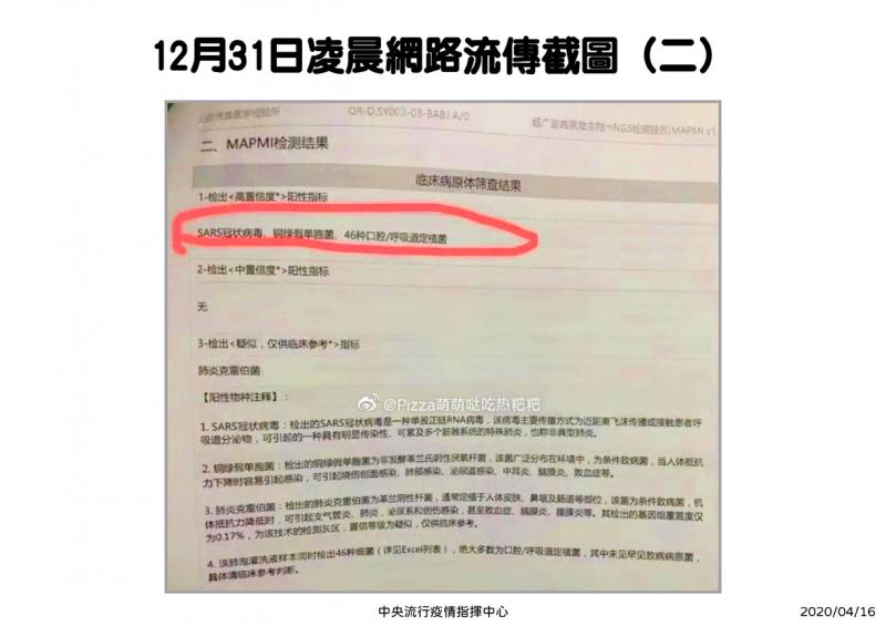
Centers for Disease Control (CDC) Deputy Director-General Philip Lo (羅一鈞) yesterday said that a post on Professional Technology Temple (PTT) was what on Dec. 31 last year alerted him about a disease outbreak in Wuhan, China.
At about 3am, a CDC doctor specializing in disease prevention had shared information from a post on PTT, the nation’s biggest online academic bulletin board system, in a private chat group, said Lo, who is also an official at the Central Epidemic Command Center.
The original post was made on PTT at about 2am, he said, adding that as he was CDC spokesman at the time, he often woke up at about 5am to look at reports.

Photo courtesy of Philip Lo
After seeing the information his colleague had shared, Lo said that he “felt, from a professional standpoint, that it was different from typical tip-offs.”
The PTT user — identified as “nomorepipe” — had included key images in their post, including a screenshot of messages sent by Chinese doctor Li Wenliang (李文亮) indicating that “seven cases of SARS” had been confirmed as originating from the Huanan Seafood Wholesale Market in Wuhan, he said.
Lo said that he became alarmed when saw “SARS.”
Severe acute respiratory syndrome coronavirus 2 (SARS-CoV-2) is the name that has since been given to the novel coronavirus that causes COVID-19.
Lo said that the lack of a date or official stamp in an examination report shared in the PTT post made him believe that it had been shared by a doctor after receiving the results.
Moreover, the messages in the screenshot looked like they were leaked from an internal chat group for medical personnel, Lo said, adding that this made the information seem more credible than other tip-offs.
Lo expressed thanks to the whistle-blowers in China, especially Li, and the PTT user, who allowed Taiwan to gain quick access to the information and succeed in its prevention efforts.

NO WORK, CLASS: President William Lai urged people in the eastern, southern and northern parts of the country to be on alert, with Typhoon Kong-rey approaching Typhoon Kong-rey is expected to make landfall on Taiwan’s east coast today, with work and classes canceled nationwide. Packing gusts of nearly 300kph, the storm yesterday intensified into a typhoon and was expected to gain even more strength before hitting Taitung County, the US Navy’s Joint Typhoon Warning Center said. The storm is forecast to cross Taiwan’s south, enter the Taiwan Strait and head toward China, the Central Weather Administration (CWA) said. The CWA labeled the storm a “strong typhoon,” the most powerful on its scale. Up to 1.2m of rainfall was expected in mountainous areas of eastern Taiwan and destructive winds are likely

KONG-REY: A woman was killed in a vehicle hit by a tree, while 205 people were injured as the storm moved across the nation and entered the Taiwan Strait Typhoon Kong-rey slammed into Taiwan yesterday as one of the biggest storms to hit the nation in decades, whipping up 10m waves, triggering floods and claiming at least one life. Kong-rey made landfall in Taitung County’s Chenggong Township (成功) at 1:40pm, the Central Weather Administration (CWA) said. The typhoon — the first in Taiwan’s history to make landfall after mid-October — was moving north-northwest at 21kph when it hit land, CWA data showed. The fast-moving storm was packing maximum sustained winds of 184kph, with gusts of up to 227kph, CWA data showed. It was the same strength as Typhoon Gaemi, which was the most

Air and rail traffic around Taiwan were disrupted today while power cuts occurred across the country as Typhoon Kong-rey, predicted to make landfall in eastern Taiwan this afternoon, continued edging closer to the country. A total of 241 passenger and cargo flights departing from or arriving at Taiwan Taoyuan International Airport were canceled today due to the typhoon, Taoyuan International Airport Corp said. As of 9:30am, 109 inbound flights, 103 outbound flights and 29 cargo flights had been canceled, the company said. Taiwan Railway Corp also canceled all express trains on its Western Trunk Line, Eastern Trunk Line, South-Link Line and attached branches

Typhoon Kong-rey is forecast to make landfall in eastern Taiwan this afternoon and would move out to sea sometime overnight, the Central Weather Administration (CWA) said. As of 9am today, Kong-rey's outer rim was covering most of Taiwan except for the north. The storm's center was 110km east of Oluanpi (鵝鑾鼻), Taiwan's southernmost tip, and moving northwest at 28kph. It was carrying maximum sustained winds near its center of 184kph, and gusts of up to 227kph, the CWA said. At a news conference this morning, CWA forecaster Chu Mei-lin (朱美霖) said Kong-rey is moving "extremely fast," and is expected to make landfall between