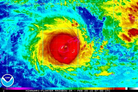
Residents of Fiji yesterday hunkered down as a ferocious cyclone tore through the Pacific island chain, prompting authorities to impose a nationwide curfew and declare a month-long state of disaster.
Wind speeds from Cyclone Winston were estimated at up to 285kph. The cyclone was late yesterday tracking along the northern coast of the main island, Viti Levu.
Fiji’s capital, Suva, located in the southern part of the main island, was experiencing high winds, but was not directly in the cyclone’s path. However, the popular tourist resorts in Viti Levu’s west were closer to the cyclone’s center.

Photo: EPA
Flights were canceled and authorities urged people to find somewhere safe to hunker down for the night and not to venture outside. A nationwide curfew was imposed at 6pm.
Fijian Prime Minister Voreqe Bainimarama said on Facebook that the island’s evacuation centers were operational and that the government was prepared to deal with a potential crisis.
“As a nation, we are facing an ordeal of the most grievous kind,” he wrote. “We must stick together as a people and look after each other.”
He said he was concerned some people in the cities were not taking the threat seriously enough.
The government declared a state of natural disaster for 30 days, giving extra powers to police to arrest people without a warrant in the interest of public safety.
The US Joint Typhoon Warning Center said gusts from the cyclone were reaching 350kph and sustained winds up to 285kph. Those speeds had eased slightly from earlier in the day.
The Fiji Times newspaper reported that some homes had had their roofs blown away and that five people had managed to swim to safety after their boat capsized.
The Times said there had been a run on supermarkets and stores as people stocked up on essential supplies before the cyclone hit.
Fiji is home to about 900,000 people.

A car bomb killed a senior Russian general in southern Moscow yesterday morning, the latest high-profile army figure to be blown up in a blast that came just hours after Russian and Ukrainian delegates held separate talks in Miami on a plan to end the war. Kyiv has not commented on the incident, but Russian investigators said they were probing whether the blast was “linked” to “Ukrainian special forces.” The attack was similar to other assassinations of generals and pro-war figures that have either been claimed, or are widely believed to have been orchestrated, by Ukraine. Russian Lieutenant General Fanil Sarvarov, 56, head

SAFETY FIRST: Double the number of police were deployed at the Taipei Marathon, while other cities released plans to bolster public event safety Authorities across Taiwan have stepped up security measures ahead of Christmas and New Year events, following a knife and smoke bomb attack in Taipei on Friday that left four people dead and 11 injured. In a bid to prevent potential copycat incidents, police deployments have been expanded for large gatherings, transport hubs, and other crowded public spaces, according to official statements from police and city authorities. Taipei Mayor Chiang Wan-an (蔣萬安) said the city has “comprehensively raised security readiness” in crowded areas, increased police deployments with armed officers, and intensified patrols during weekends and nighttime hours. For large-scale events, security checkpoints and explosives

PUBLIC SAFETY: The premier said that security would be tightened in transport hubs, while President Lai commended the public for their bravery The government is to deploy more police, including rapid response units, in crowded public areas to ensure a swift response to any threats, President William Lai (賴清德) said yesterday after a knife attack killed three people and injured 11 in Taipei the previous day. Lai made the remarks following a briefing by the National Police Agency on the progress of the investigation, saying that the attack underscored the importance of cooperation in public security between the central and local governments. The attack unfolded in the early evening on Friday around Taipei Main Station’s M7 exit and later near the Taipei MRT’s Zhongshan

REBUFFED: In response to Chinese criticism over recent arms sales, Washington urged Beijing to engage in meaningful dialogue instead of threats and intimidation Washington’s long-term commitment to Taiwan would not change, the US Department of State said yesterday, urging Beijing to stop pressuring Taiwan and engage in meaningful bilateral dialogues. The remarks came in response to a backlash from Beijing about Washington’s latest approval of arms sales to Taiwan. The US Defense Security Cooperation Agency said in a statement on Wednesday that the Taipei Economic and Cultural Representative Office in the US has asked to purchase an arms package, including Tactical Mission Network Software; AH-1W helicopter spare and repair parts; M109A7 self-propelled howitzers; HIMARS long range precision strike systems; tube-launched, optically tracked, wire-guided missiles; Javelin