The Suhua Highway (蘇花公路) is one of Taiwan’s most famous — and most infamous — roads. Winding its way along marble cliffs high above the Pacific Ocean, the scenery is unparalleled. However, this narrow road is full of blind turns and prone to rockslides, so for years, many avoided this section altogether, where the only thing stopping you from plummeting into the Pacific below is a thin metal guardrail.
The newest iteration of the road is the “Improved Suhua Highway” (蘇花改), which opened in 2020 and now carries the Highway No. 9 designation. Through a more inland route and a collection of long tunnels, it will be less affected by landslides and provide a safer experience for drivers. Scooters and bicycles are not allowed on this road, but are instead confined to the pre-2020 “old” Suhua Highway, now designated as Highway No. 9D (9丁). Since the heavy traffic has moved to the new road, it is now a much safer and more enjoyable route, especially on foot.
THE OLD, THE OLDER AND THE OLDEST
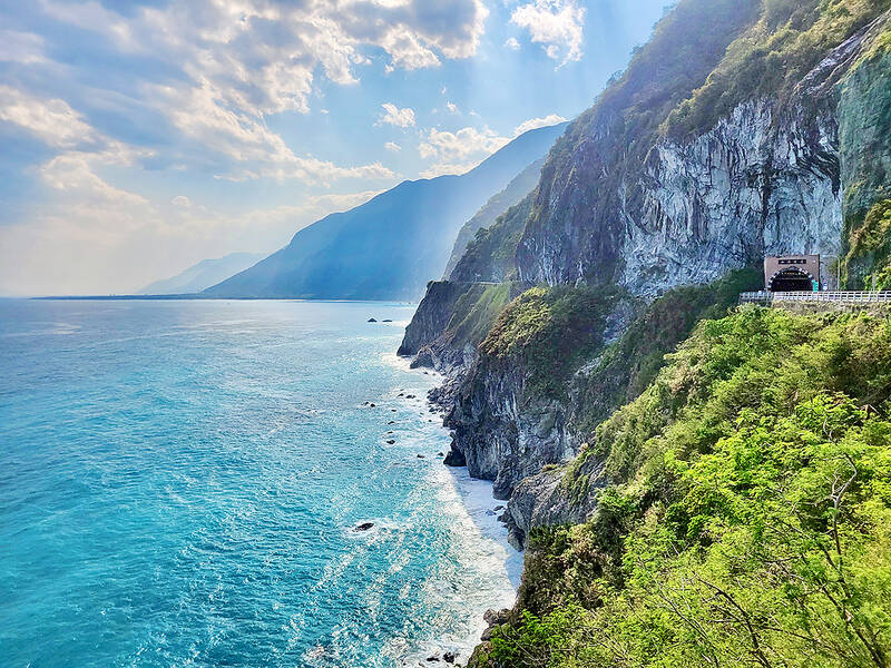
Photo: Tyler Cottenie
From the “old” Suhua Highway’s official start in Suao Township (蘇澳), it climbs up and follows the coastline, providing exceptional views of faraway Turtle Island (龜山島) and Dark Rock Cape (烏岩角) 400 meters below, where the end of the Central Mountain Range dives into the Pacific. After rounding this corner, the beautiful bay in front of Dongao (東澳) comes into view as the highway winds its way down to this next major town. Before 1980, this stretch of road had only one lane and traffic proceeded in one direction at a time, controlled by checkpoints in Suao and Dongao.
At Dongao, car and truck traffic rejoins Highway No. 9, which proceeds up and down again to the next town, Nanao (南澳). Prior to 1983, this section of highway was also single-lane, with directional controls on either end, and it went around the mountain instead of through it via the Sinao Tunnel. Just before this tunnel, the pre-1983 road veers off to the left and is still in great shape. You can walk on it as far as the Wushihbi Tunnel, whose entrance is now barred.
The pre-1983 highway rejoins the current road on the other side of the Sinao Tunnel, at the 120.2K mark. Walking through an opening in the trees on the left here, you can get back onto the older road again. All of the highway infrastructure is still visible as is most of the blacktop, though it is slowly being covered up by vegetation.
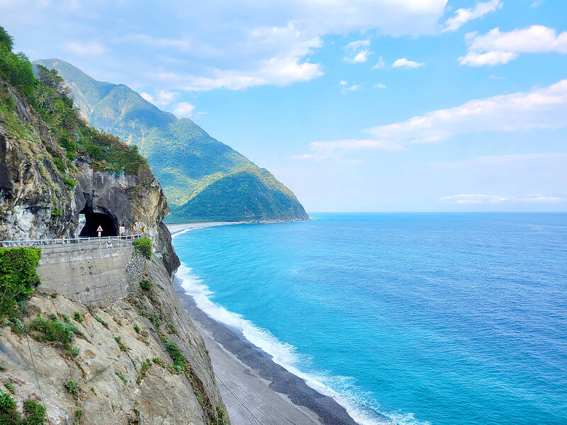
Photo: Tyler Cottenie
If you continue along this older road, even though you are actually northbound now, there is still a way down to Nanao. After a kilometer or two, the road intersects with the oldest of the routes from Yilan to Hualien, one that dates back to the Qing Dynasty and that has seen use as a camphor delivery and alcohol smuggling route. Turning right here and following the footpath downhill will get you to Nanao, where car and truck traffic again separates from the Highway No. 9.
LANDMARKS LOST TO TIME
After Nanao, the road continues to provide beautiful views of the Pacific coast. This stretch of road was still single-lane as late as 1990, with traffic directional controls set up at Gufong (谷風) in Yilan County, and on the other side of the river in Hualien County, at Heping, home to Taiwan Cement’s Heping Plant. The dusty, industrial feeling of this area contrasts sharply with the clean, pristine beauty of the rest of the Suhua Highway.
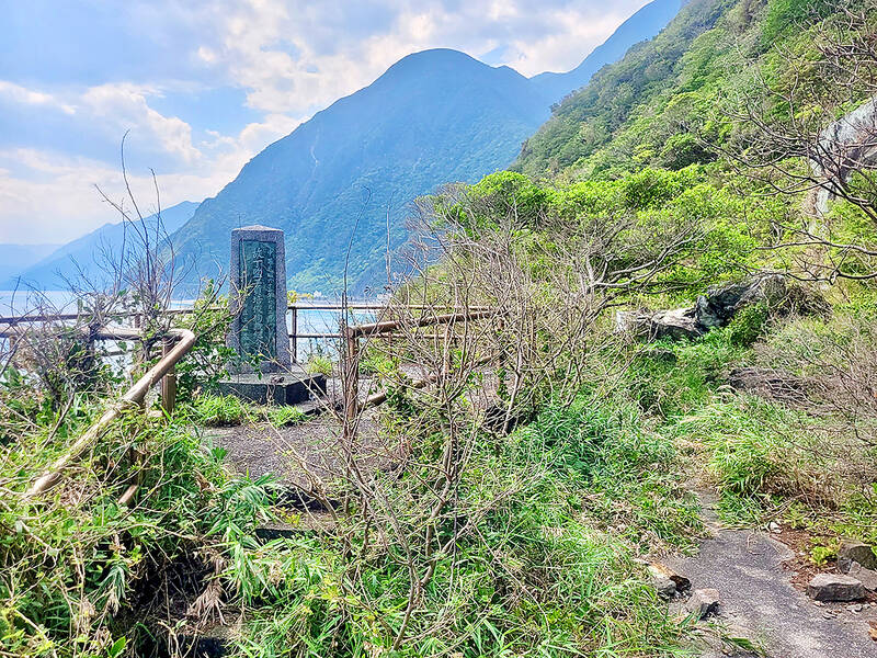
Photo: Tyler Cottenie
The remaining stretch of highway from here to Chongde (崇德) was also only opened to two-lane traffic in 1990. However, this was achieved not only through widening of existing roadway but also through the construction of several new tunnels. Large parts of the narrow pre-1990 road that hugged the coast were thus entirely abandoned. This single-lane precursor to the Suhua Highway actually dates back to the Japanese-era. Between 1916 and 1923, a walking path was built from Suao to Hualien, and then later expanded to allow for car traffic by 1932. Between Heping Township (和平) and Hualien, 11 tunnels were built, only one of which remains in active use. Fortunately, it is still relatively easy to see stretches of this single-lane road and its tunnels, especially on foot.
The current Heping Tunnel bypasses an older version of the Heping tunnel, built in 1950, and the remains of Japanese tunnels 8 through 11, all of which were built right on the edge of a cliff. They can be accessed with climbing gear from the beach on the north end, and by a treacherous rope descent on the south side of Heping Tunnel (look over the guardrail at the pullout for cars), followed by a walk along the coast at low tide. The outer wall of Japanese Tunnel 8 is shaped like an elephant trunk and was featured on the old NT$1 banknote.
Just to the left of the Hejhong Tunnel entrance, the older road along the cliff is visible. Walk out a short distance on this to get a sense for how fast regular rockfall can overwhelm a road, and to see how precariously this road was carved into the cliff. Japanese Tunnel 7 was also out on this cliff but has collapsed.
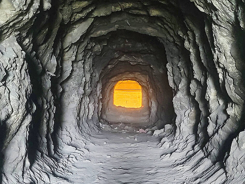
Photo: Tyler Cottenie
The next tunnel is Heren Tunnel, and three different side tunnels within provide access to the outside cliffs. Walk out these side tunnels to see more of the single-lane Suhua Highway that dates back to Japanese times, and a roadside monument to Ting Pei-chun (丁培俊) who died while repairing landslide damage to the road in 1973.
Speaking of landmarks, after the town of Heren, the entrance to Taroko National Park (太魯閣國家公園) is marked by a large roadside sign, after which the Suhua passes through Japanese Tunnel 6, built in 1921 and the only one still in use today.
THE FINAL PUSH
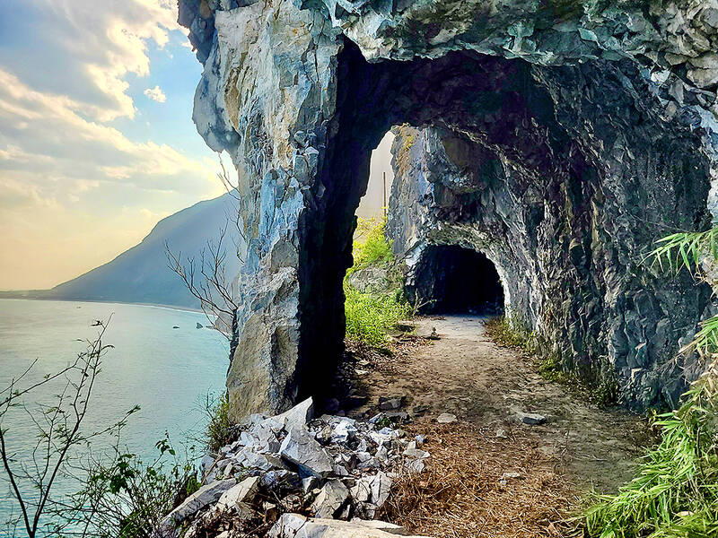
Photo: Tyler Cottenie
After passing through Rencing and Hecing tunnels, the road rejoins car and truck traffic at the Dacingshuei Recreation Area (大清水遊憩區), and walking beside the road becomes a lot louder and dustier. Passing through the Dacingshuei Tunnel is rather uneventful, but the next two tunnels (Tunnel No. 13 and Jinwun Tunnel) are full of interesting side trips. Take all the access routes to the outside on the left to see several of the remaining Japanese tunnels (tunnels 1 through 5) and other parts of the narrow road hewn right into the marble cliffs. The views of the ocean here are incredible on their own, but paired with the remnants of the old road, they are especially grand. It’s best to enjoy the Suhua on a sunny day when the blues and greens of the ocean really shine.
Next is the Hueide Rest Stop. When the Suhua was fully opened to two-way traffic in 1990, it still stuck close to the cliffs beyond here, and passed through the Cingshuei Tunnel, also completed in 1990. In 2000, the Hueide Tunnel opened, bypassing this cliffside section of road altogether. The Cingshuei Tunnel, only in use for 10 years, was abandoned, and the bypassed section of the road opened to pedestrian traffic. Part of this road, including the tunnel, has now been closed due to landslides, but some of it is still walkable from the Hueide Rest Stop.
After passing through the Hueide and Chongde Tunnels, the road reaches Chongde, the final traffic control point from the Suhua’s single-lane days. From here to Hualien City, the Suhua Highway is a fairly ordinary road across flat ground with no historical remains to speak of.
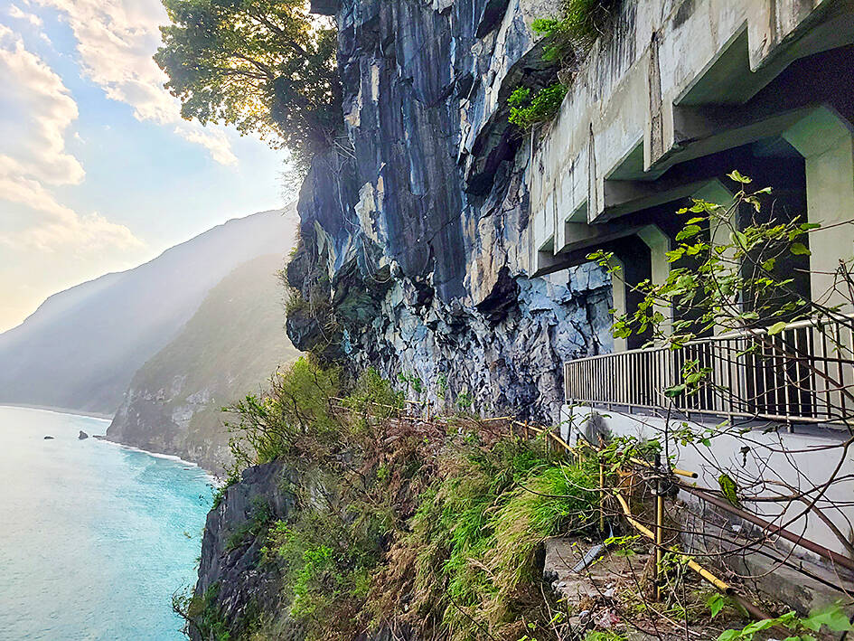
Photo: Tyler Cottenie
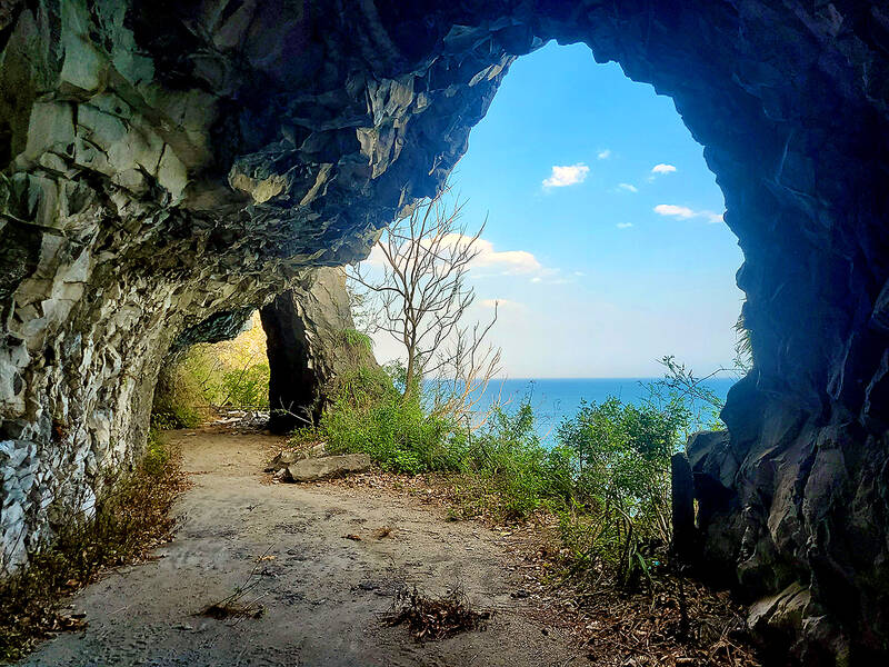
Photo: Tyler Cottenie
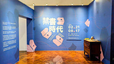
From censoring “poisonous books” to banning “poisonous languages,” the Chinese Nationalist Party (KMT) tried hard to stamp out anything that might conflict with its agenda during its almost 40 years of martial law. To mark 228 Peace Memorial Day, which commemorates the anti-government uprising in 1947, which was violently suppressed, I visited two exhibitions detailing censorship in Taiwan: “Silenced Pages” (禁書時代) at the National 228 Memorial Museum and “Mandarin Monopoly?!” (請說國語) at the National Human Rights Museum. In both cases, the authorities framed their targets as “evils that would threaten social mores, national stability and their anti-communist cause, justifying their actions
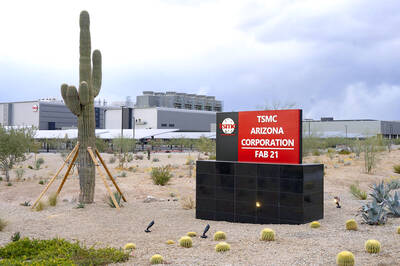
Taiwanese chip-making giant Taiwan Semiconductor Manufacturing Co (TSMC) plans to invest a whopping US$100 billion in the US, after US President Donald Trump threatened to slap tariffs on overseas-made chips. TSMC is the world’s biggest maker of the critical technology that has become the lifeblood of the global economy. This week’s announcement takes the total amount TSMC has pledged to invest in the US to US$165 billion, which the company says is the “largest single foreign direct investment in US history.” It follows Trump’s accusations that Taiwan stole the US chip industry and his threats to impose tariffs of up to 100 percent

In the run-up to World War II, Admiral Wilhelm Canaris, head of Abwehr, Nazi Germany’s military intelligence service, began to fear that Hitler would launch a war Germany could not win. Deeply disappointed by the sell-out of the Munich Agreement in 1938, Canaris conducted several clandestine operations that were aimed at getting the UK to wake up, invest in defense and actively support the nations Hitler planned to invade. For example, the “Dutch war scare” of January 1939 saw fake intelligence leaked to the British that suggested that Germany was planning to invade the Netherlands in February and acquire airfields

The launch of DeepSeek-R1 AI by Hangzhou-based High-Flyer and subsequent impact reveals a lot about the state of the People’s Republic of China (PRC) today, both good and bad. It touches on the state of Chinese technology, innovation, intellectual property theft, sanctions busting smuggling, propaganda, geopolitics and as with everything in China, the power politics of the Chinese Communist Party (CCP). PLEASING XI JINPING DeepSeek’s creation is almost certainly no accident. In 2015 CCP Secretary General Xi Jinping (習近平) launched his Made in China 2025 program intended to move China away from low-end manufacturing into an innovative technological powerhouse, with Artificial Intelligence