Each peak along the South Second Section (南二段) gives hikers a quick look at the terrain already covered, and ahead at the peaks that still must be summited. The feeling of accomplishment grows with each passing peak, as the amount of terrain behind increases and the amount remaining shrinks. There’s a peculiar blend of pride, humility and gratitude that every hiker is sure to feel on one of these peaks: pride, for overcoming the challenges of traversing this rugged, remote landscape; humility, from the understanding that poor weather, injuries or simply bad luck can strike at any time; and gratitude, for not actually running into such bad luck, and for being one of the few who get to experience these majestic views of Taiwan from above day after day.
South Second Section is the perfect introduction to longer traverses in Taiwan for those who already have some experience with trips lasting three or four days. Its location within Yushan National Park means that the trail is (relatively) clear, and there are basic mountain huts one can reserve for all six nights of the trip, meaning there is no need to haul around a tent. The scenery is second-to-none, with gorgeous sunrises, alpine bamboo meadows, up to ten of the 100 Peaks of Taiwan, and even some historical remains thrown in for good measure.
The section’s name comes from the division of the spine of the Central Mountain Range by hikers into manageable chunks that take approximately a week each to hike: three in the north and three in the south. South Second Section lies between the South Cross-Island Highway (南橫公路) and the New Central Cross-Island Highway (新中橫公路). It is most commonly accessed from Siangyang Forest Recreation Area (向陽森林遊樂區) in Taitung County on one end and Dongpu Village (東埔) in Nantou County on the other. In fact, some of the most interesting and scenic parts of the hike are on these access trails.
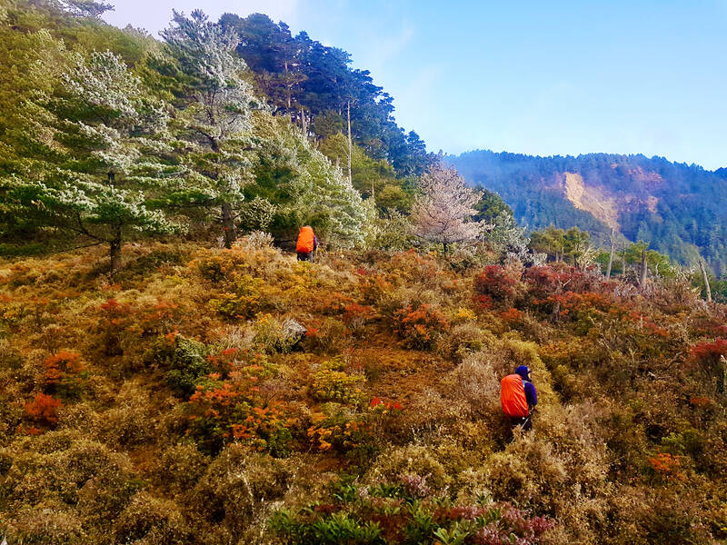
Photo: Tyler Cottenie
THE ANGEL’S TEARDROP
When accessing the trail from the south, you get to pass by Jiaming Lake (嘉明湖), a destination to which many hikers already dedicate a whole three-day trip. This round alpine lake sits next to Sancha Mountain (三叉山) in a shallow depression, totally surrounded by golden bamboo. When the sky is clear, the blue reflection from its surface is breathtaking, and has earned it the name “Angel’s Teardrop” (天使的眼淚) among locals. Some hikers, however, claim that the only tears on this trail are their own, as the hike does involve a lot of ups and downs at high elevations with less oxygen in the air.
For those doing South Second Section, the most comfortable itinerary involves getting to the trailhead on the first day at Siangyang Forest Recreation Area and walking two hours to Siangyang Cabin, which features wide bunks with individual curtains and a large deck with picnic tables. Spending a night here at around 2,850 meters above sea level is a great way to start acclimatizing to higher elevations.
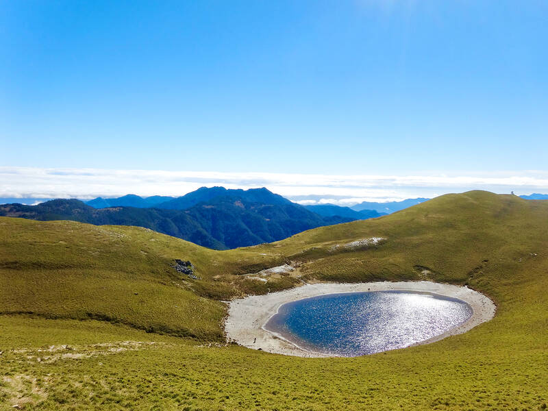
Photo: Tyler Cottenie
The next day, follow the crowd up past Jiaming Lake Cabin and onward to the lake — with side trips to Siangyang (向陽) and Sancha mountains if you like. Turning north at the junction just before the lake, you will leave the crowds behind and soon reach a wooden sign at the very top of the ridge marking the start of South Second Section.
ALONG THE SPINE
The trail descends sharply to the Lakuyin River (拉庫音), a clear blue stream that serves as a water source for your stay at the adjacent red A-frame cabin. Rest up, because the next day is the longest of the trip. A long climb first thing in the morning puts you at the top of Nanshuangtou Mountain (南雙頭). The first two or three minutes after sunrise, whether you are still ascending or at the peak, are a very special time on a clear day. At its low angle, the sun bathes the bamboo slope in a fiery, golden light that is as impressive as it is ephemeral.
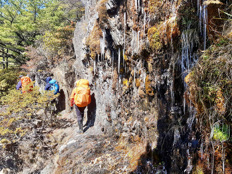
Photo: Tyler Cottenie
Next is Cloud Peak (雲峰), a three or four-hour side trip. For those bagging the 100 Peaks, this trip is essential, and the view at the top of the Jade Mountain Range, only 10 km away, is a worthy reward. However, if peak bagging isn’t your thing, skip Cloud Peak and this day will be a whole lot easier. Accommodations for the night are in another A-frame cabin, nestled in the Lulu Valley (轆轆).
Days 4 and 5 are full of ups and downs along the spine, with the Jade Mountain Range passing by on the left. You will have the opportunity to summit Lulu Mountain, Tafen Mountain (塔芬) and Dafenjian Mountain (達芬尖), and will stay at the Tafen Valley Cabin, located in a steep-sided, forested valley with a natural spring nearby. Day 5 has a dramatic finish as you climb up to Dashuiku Mountain’s (大水窟) South Peak, a flat area with 360-degree views over the route from the previous 4 days and the exit routes ahead.
As you descend from this peak, Dashuiku Cabin will first appear as a tiny red dot next to a blue pond in the sea of dwarf bamboo down below. Dashuiku was an important mountain pass in the past. The Batongguan Trails (八通關) built during the Qing Dynasty and Japanese colonial era both passed over the Central Mountains at this point, and it is today the nexus of several hiking routes. A kilometer to the southeast are the remains of a Japanese police post, and about a hundred meters from the cabin are the remains of a stone platform where the Japanese marked the boundary between Hualien and Nantou.
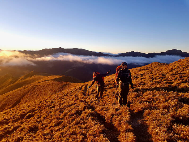
Photo: Tyler Cottenie
SEVERAL WAYS DOWN
The last peak of South Second Section proper is Dashuiku Mountain to the north of the cabin. On Day 6, you may want to carry all your gear up to this peak and then continue down to the next saddle. From here, the very ambitious can attempt the side trip to Xiuguluan Mountain (秀姑巒), the highest peak in the Central Mountains. Heading west from the saddle, you will descend to Baiyang Gold Mine Cabin. Be sure to stop and look at the water source behind the cabin. The water drips down a small cliff, into which a mining tunnel was dug years ago. Further down you will reach Zhongyang Gold Mine Cabin, your last night’s accommodation.
Instead of the above, some people opt to do Dashuiku Mountain as a side trip, and then take the Japanese Batongguan trail down from Dashuiku. This is a gentle slope all the way down to Zhongyang Gold Mine Cabin. Unfortunately, since a wildfire in 2021, this trail has been officially closed to the public, though many hikers continue to use it.
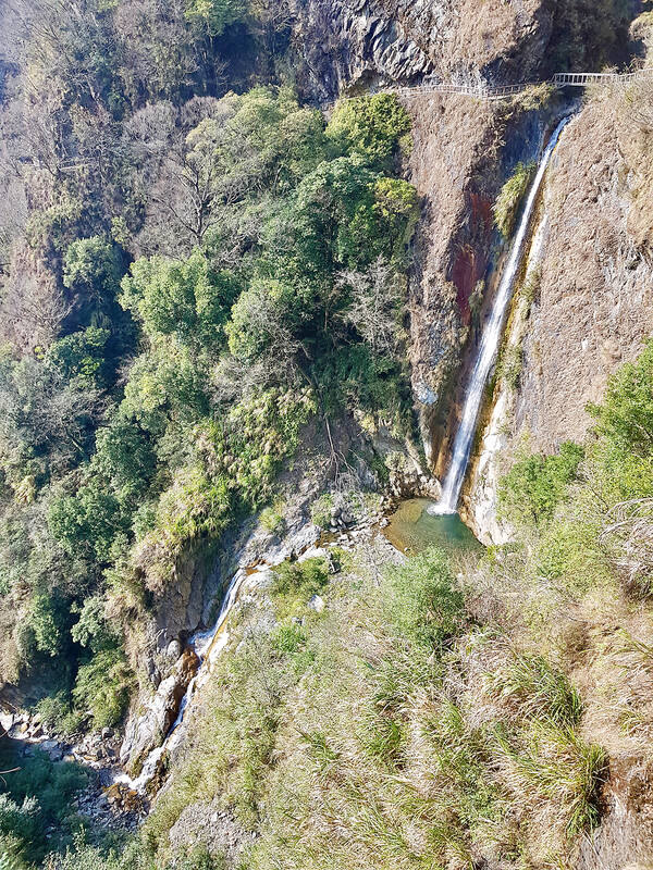
Photo: Tyler Cottenie
The last day is quite long but follows the gently sloping Japanese Batongguan Trail most of the way down. The last optional side trip is to Batongguan Mountain, and for those with another day available, an alternate exit would be to summit Jade Mountain from the back side and exit via the traditional route. Otherwise, proceed down the Batongguan all the way to the hot spring village of Dongpu (東埔).
Most importantly, plan on a half-hour break for a bowl of fig jelly and grilled sausages. There are two vendors set up selling similar products at very reasonable prices, located right where the end of the trail connects with Nantou farm roads. Welcome back to civilization!
IF YOU GO
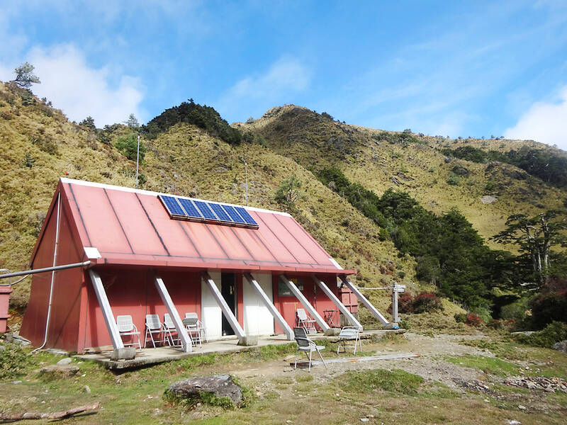
Photo: Tyler Cottenie
LOGISTICS:
The south trailhead can be reached by private shuttle, hired at Guanshan (關山) or Chihshang (池上) train stations for approximately NT$2,500.
Dongpu Village near the north trailhead has bus service connecting to Shueili in Nantou, where onward bus or train connections can be made.
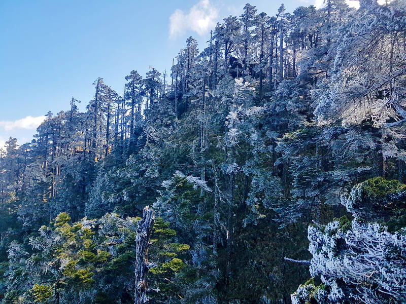
Photo: Tyler Cottenie
Permits (including cabin spaces) must be booked in advance through the National Park’s Web site: npm.cpami.gov.tw/en/apply_1.aspx

If you are a Western and especially a white foreign resident of Taiwan, you’ve undoubtedly had the experience of Taiwanese assuming you to be an English teacher. There are cultural and economic reasons for this, but one of the greatest determinants is the narrow range of work permit categories that exist for Taiwan’s foreign residents, which has in turn created an unofficial caste system for foreigners. Until recently, laowai (老外) — the Mandarin term for “foreigners,” which also implies citizenship in a rich, Western country and distinguishable from brown-skinned, southeast Asian migrant laborers, or wailao (外勞) — could only ever
Sept. 23 to Sept. 29 The construction of the Babao Irrigation Canal (八堡圳) was not going well. Large-scale irrigation structures were almost unheard of in Taiwan in 1709, but Shih Shih-pang (施世榜) was determined to divert water from the Jhuoshuei River (濁水溪) to the Changhua plain, where he owned land, to promote wet rice cultivation. According to legend, a mysterious old man only known as Mr. Lin (林先生) appeared and taught Shih how to use woven conical baskets filled with rocks called shigou (石笱) to control water diversion, as well as other techniques such as surveying terrain by observing shadows during

In recent weeks news outlets have been reporting on rising rents. Last year they hit a 27 year high. It seems only a matter of time before they become a serious political issue. Fortunately, there is a whole political party that is laser focused on this issue, the Taiwan Statebuilding Party (TSP). They could have had a seat or two in the legislature, or at least, be large enough to attract media attention to the rent issue from time to time. Unfortunately, in the last election, Taiwan People’s Party (TPP) Chairman Ko Wen-je (柯文哲) acted as a vote sink for
This is a film about two “fools,” according to the official synopsis. But admirable ones. In his late thirties, A-jen quits his high-paying tech job and buys a plot of land in the countryside, hoping to use municipal trash to revitalize the soil that has been contaminated by decades of pesticide and chemical fertilizer use. Brother An-ho, in his 60s, on the other hand, began using organic methods to revive the dead soil on his land 30 years ago despite the ridicule of his peers, methodically picking each pest off his produce by hand without killing them out of respect