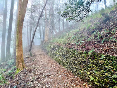
This holy ridge!
How many people can bear the honor
of making the trek between these two mountains
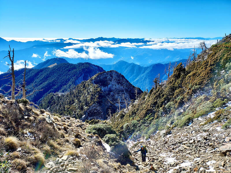
Photo: Tyler Cottenie
and speaking of this ridge's true beauty?
These are the words that Numai Tetsutaro, a monopoly bureau employee during Japanese colonial rule and founder of the Taiwan Mountaineering Association, put to paper after summiting Dabajian Mountain (大霸尖山) in 1927 and gazing across the rugged ridgeline connecting it to Snow Mountain (雪山). He would never get the chance to walk this route and speak of its true beauty, but the name “Holy Ridge” (聖稜線) stuck. The first recorded traverse was made a few years later, and hikers have been drawn to this legendary hike ever since.
The advantages of this route are hard to overstate. For peak baggers, there are as many as eleven of the 100 Peaks of Taiwan up for grabs. Nowadays, there are enough cabins in the right places that it’s possible to sleep indoors every night. The scenery is rugged and beautiful, with rocky, exposed ridges that offer commanding views on both sides. Much of this beauty comes from the unusual patterns of erosion here that are evidence of past glacial activity. Famed Japanese naturalist Tadao Kano recorded 35 glacial cirques in the Snow Mountain area, of which more than a dozen are visible from the Holy Ridge.
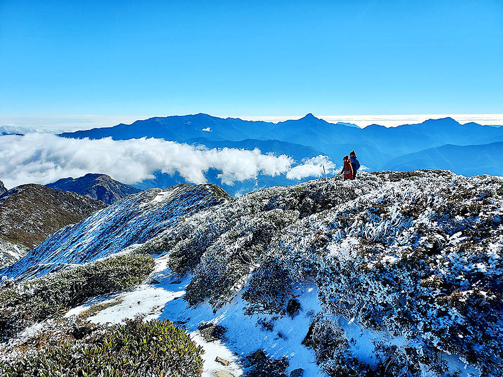
Photo: Tyler Cottenie
O, Y AND I ROUTES
Though the Holy Ridge itself is the ridge connecting Taiwan’s second-highest mountain, Snow Mountain, with Dabajian Mountain, the various access trails and side peaks can be combined to form different itineraries. The three standard routes nowadays all start or finish at the regular Snow Mountain trailhead, and are named after the approximate shape they trace out on a map: O, Y and I. All require permits from Shei-Pa National Park.
The “O” and “Y” routes start and end in Taichung County’s Wuling Farm (武陵農場), simplifying transportation. The “O” route is the shortest and covers seven of the 100 Peaks, while the “Y” route adds a side trip of two more days and four more peaks. The “I” route covers seven peaks but exits in a different county on the other side of the island, complicating transportation. All treks offer similar views and you really can’t go wrong choosing a route.
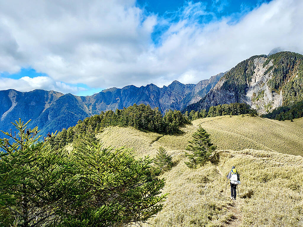
Photo: Tyler Cottenie
For this author’s hike, we walked the entire Holy Ridge but opted for a non-traditional entry and exit point. We reached the peak of Snow Mountain by way of its south side, which was the standard access route during the Japanese era when the term “Holy Ridge” was coined. We were treated to excellent weather and a dusting of snow and ice: just enough to make the views even more magical but not enough to make this a truly death-defying hike, which — make no mistake — it certainly can be during the winter.
REACHING THE SUMMIT
The ascent up the south ridge of Snow Mountain is long and steep, taking at least a day and a half. It’s no wonder this is no longer the preferred access route. During the Japanese era, a cabin was constructed here that could hold up to 100 hikers. Unfortunately, no trace of the building remains today, but the site is now a wide flat area on an otherwise steep ridge, making for a lovely campsite, complete with nearby water source.

Photo: Tyler Cottenie
Between the campsite and the peak of Snow Mountain, we did not see a single person. For peace and quiet, this route sure beats the traditional route that over a hundred hikers take each day. As we neared the peak, we passed the treeline and continued walking up an exposed talus slope. Chunks of rock broken up from continual freeze-thaw cycles, landslides and wind erosion were strewn all around us, reaffirming how high we had ascended already and that the forces of nature up here were harsh and unforgiving, not only to life but to the land itself.
Upon cresting the peak, the landscape turned shockingly white. The Holy Ridge, now laid out in its entirety before our eyes, was covered in snow. We had crampons with us, as required by regulations, but even with crampons there are sections of the Holy Ridge where one missed step could mean the difference between getting home to write an article about the trip and plummeting to an untimely death. Filled with both awe and trepidation, we pushed onward.
HIKING THE HOLY RIDGE
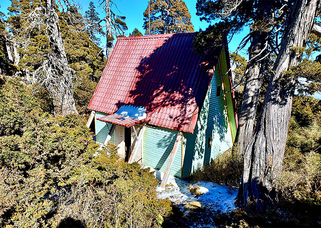
Photo: Tyler Cottenie
The thing about the Holy Ridge is that you can never let your guard down. Immediately after a short descent from the peak, there is a tricky climb up a cliff using ropes. Luckily this cliff faces south so the snow and ice here had melted. After reaching the top, we could see a giant bowl of snow on either side of us: these are the two largest cirques carved out by glaciers millennia ago.
After passing the Syuebei (“Snow North”) Hut, affectionately known as the Fairy Tale Cabin, the terrain got more and more difficult. Every time the trail dipped over to the north side, we were faced with much heavier snow and ice. Near Sumida Mountain (素密達山), there is a rope ascent up a nearly vertical creek bed, followed by two fully vertical ascents up ladders.
This is not a trail for acrophobes. At the top of these ladders, the terrain is covered in boulders, there is no path to speak of and venturing too far off to either side results in a dizzying view down a cliff. Things were made more difficult by the patches of ice all around threatening to send us sliding away toward these very cliffs.
After safely passing through this most rugged and adrenaline-inducing section, the Holy Ridge descends into the forest past another cabin and comes out at the heavily eroded base of Dabajian Mountain. This stunning block of rock has sheer cliffs on all four sides and is one of the most photogenic peaks on the island. Ascents used to be possible via ladders, but these were removed in 1991 and summiting is now forbidden.
Hiking by the base is nevertheless a dramatic experience. On one side is a 100-meter-high wall of rock, and on the other is a talus slope dropping down to a creek far below. Evidence of recently fallen rocks is obvious right beside the trail so helmets are recommended. Water is often dripping onto the trail from the cliff face, and in winter this can leave a long strip of ice exactly covering the trail.
After passing by Dabajian, the Holy Ridge is officially over. If you go, don’t forget to turn around and look back: the whole route you just spent nearly three days walking is still visible, from the peak of Snow Mountain in the distance, to the treacherous Sumida Mountain slopes, to the showpiece Dabajian Mountain. Finish up the other peaks nearby and go home (“I” route), head toward the Wuling Four Peaks (“Y” route) or head down the less popular north ridge through thick bamboo to the towering cypress trees at the Jhensibao (鎮西堡) trailhead as the author did.
Whichever route you take, enjoy the honor of having completed one of Taiwan’s most legendary high-mountain hikes, and the privilege of having experienced the beauty that Numai Tetsutaro could only dream of nearly a century ago.

The 1990s were a turbulent time for the Chinese Nationalist Party’s (KMT) patronage factions. For a look at how they formed, check out the March 2 “Deep Dives.” In the boom years of the 1980s and 1990s the factions amassed fortunes from corruption, access to the levers of local government and prime access to property. They also moved into industries like construction and the gravel business, devastating river ecosystems while the governments they controlled looked the other way. By this period, the factions had largely carved out geographical feifdoms in the local jurisdictions the national KMT restrained them to. For example,

With over 100 works on display, this is Louise Bourgeois’ first solo show in Taiwan. Visitors are invited to traverse her world of love and hate, vengeance and acceptance, trauma and reconciliation. Dominating the entrance, the nine-foot-tall Crouching Spider (2003) greets visitors. The creature looms behind the glass facade, symbolic protector and gatekeeper to the intimate journey ahead. Bourgeois, best known for her giant spider sculptures, is one of the most influential artist of the twentieth century. Blending vulnerability and defiance through themes of sexuality, trauma and identity, her work reshaped the landscape of contemporary art with fearless honesty. “People are influenced by
The remains of this Japanese-era trail designed to protect the camphor industry make for a scenic day-hike, a fascinating overnight hike or a challenging multi-day adventure Maolin District (茂林) in Kaohsiung is well known for beautiful roadside scenery, waterfalls, the annual butterfly migration and indigenous culture. A lesser known but worthwhile destination here lies along the very top of the valley: the Liugui Security Path (六龜警備道). This relic of the Japanese era once isolated the Maolin valley from the outside world but now serves to draw tourists in. The path originally ran for about 50km, but not all of this trail is still easily walkable. The nicest section for a simple day hike is the heavily trafficked southern section above Maolin and Wanshan (萬山) villages. Remains of
April 14 to April 20 In March 1947, Sising Katadrepan urged the government to drop the “high mountain people” (高山族) designation for Indigenous Taiwanese and refer to them as “Taiwan people” (台灣族). He considered the term derogatory, arguing that it made them sound like animals. The Taiwan Provincial Government agreed to stop using the term, stating that Indigenous Taiwanese suffered all sorts of discrimination and oppression under the Japanese and were forced to live in the mountains as outsiders to society. Now, under the new regime, they would be seen as equals, thus they should be henceforth