With some fanfare — and a bit of skepticism among the cycling public — on March 12 this year President Tsai Ing-wen (蔡英文), Premier Su Tseng-chang (蘇貞昌) and Council of Agriculture Minister Chen Chi-chung (陳吉仲) inaugurated what’s being described as the country’s longest bikeway.
Boasting a total length of 87.5km (according to English-language reports) or 88km (the figure given by Chinese-language media), the cycling route connects Tainan City, Chiayi County and Yunlin County.
As soon as I heard about this bikeway, I knew I’d give it a try. I also realized that doing so as soon as possible — before the weather got uncomfortably hot or wet — made sense.

Photo: Steven Crook
So I did what I’m good at. I procrastinated. Flimsy excuses reinforced legitimate reasons. It wasn’t until early one morning late last month that I launched my unsuccessful yet oddly satisfying first attempt to cycle the entire thing.
To get to the southern end of the new trail, I rode along quiet country roads, a section of Provincial Highway 1 and a stretch of the cyclist-friendly Mountains to Sea National Greenway (山海圳國家級綠道). I’ve described part of this older greenway in a previous article (“Lakeside to seaside, by bike and car,” in the July 16, 2021 Taipei Times).
Finding the actual starting point of the new bicycle path, the official name of which is the Canal Greenway (水圳綠道), was a little tricky. Its southern end, I now know, dovetails with the Mountains to Sea National Greenway at the Chianan Irrigation Association (嘉南農田水利會) substation in Wushantou Borough (烏山頭里) in Guantian District (官田).
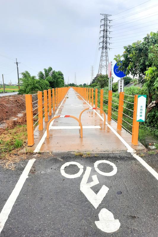
Photo: Steven Crook
There’s no English-language sign or mapboard there (or, for that matter, anywhere else along the Canal Greenway). However, the blue-and-white Chinese signs that have been stenciled every few hundred meters on the surface of the trail are obvious enough.
The cycling route initially follows the eastern embankment of the Chianan irrigation system’s major north-south watercourse, but soon switches over to the west side. I’d not gone far at all before I realized that while this landscape was highly familiar — I’ve traveled countless times between Tainan and Chiayi by train, car, bus, motorcycle and bicycle — I was seeing it all from a fresh angle.
Around 3.6 km from the starting point, I stopped to take a photograph of an unusual steeple-roofed sentry box. Near the km17 marker, I came across two more of these oddities.
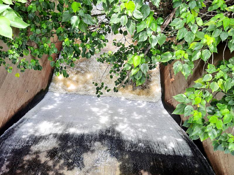
Photo: Steven Crook
After passing the km10 marker, I noticed that the fencing alongside the greenway hadn’t been finished. A few hundred meters further along, I came across construction work, then a 206m-long metal aqueduct.
It appears to be a sturdy structure, yet its height and narrowness makes crossing Gueijhong Creek (龜重溪) an unnerving experience. On the north bank, I pushed through deep mud, negotiated a shoulder-high barrier, cleaned my tires then pedaled on.
THE NEED FOR TREES
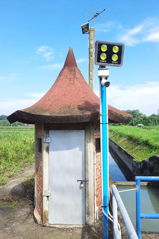
Photo: Steven Crook
The government has promised to plant 100,000 trees along the Canal Greenway, to provide much-needed shade, but I didn’t see any new trees until I reached Dongshan District (東山). As I cycled, I startled dozens of skinks and other lizards basking on the exposed concrete bikeway.
More than three quarters of the Tainan section of the Canal Greenway, I’d estimate, was purpose built for cyclists. Only in a few places do bikes have to share the thoroughfare with faster vehicles. Several long stretches of bikeway have replaced levee-top maintenance roads. In both Tainan’s Houbi District (後壁) and Chiayi County’s Shueishang Township (水上), the new greenway overlaps with older bike paths.
The route keeps cyclists away from traffic, but it also stays out of human settlements. Carry snacks and liquids, or plan on making detours.
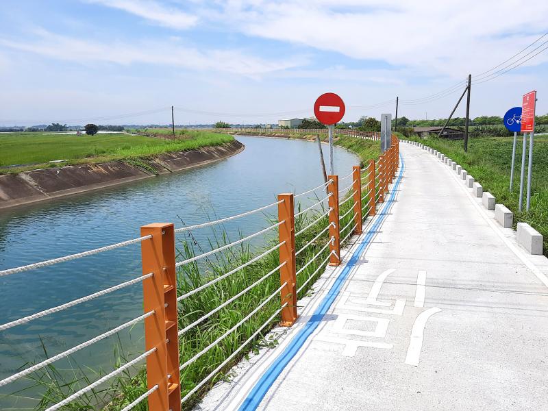
Photo: Steven Crook
Another aqueduct takes cyclists over the Bajhang River (八掌溪) and into Chiayi County. The bike route then goes under the main north-south railroad close to Nanjing TRA Station (南靖火車站), near which Nanjing Sugar Factory (南靖糖廠) is an unmissable landmark.
Over the next few kilometers, I may well have strayed from the official route. For a while I was on a backroad, not a bikeway. But it didn’t seem to matter. By the time I approached the unremarkable village of Dajuewei (大掘尾), where I crossed Road 168, I was again on a watercourse-hugging bike trail.
West of Chiayi’s civilian-military airport, there was some relief from the sun, thanks to the afforesting of land once used for growing sugar. The canal here is home to scores of herons and egrets. Whenever an F-16 flew over, low and loud, these birds didn’t budge. But the moment they saw a lone cyclist…
As midday approached — and the mercury climbed — I realized I was getting seriously depleted. After reaching the km40 marker near Taibao (太保), I veered away from Canal Greenway and toward the center of Chiayi City.
DAY TWO
The day I’d set aside to complete the bikeway started as I feared it would. It rained before I left home, and again on the train to Chiayi. Before I’d left the city, a heavy thunderstorm forced me to take shelter.
Under a sky that spent half the afternoon whispering watery threats, and the other half making good on them, I rejoined the Canal Greenway on the outskirts of Singang (新港).
Despite the rain — and a bikeway apparently designed so it wouldn’t drain — the surface wasn’t slippery. Instead of dodging lizards, I had to negotiate swarms of snails.
In good weather, Beilun Frog-themed Painted Village (北崙青蛙彩繪村) is probably quite photogenic. But I didn’t feel like I had time to stop, so I followed signposts that sent me onto Road 145A (145甲), across the Beigang River (北港溪), and into Yunlin County.
Just as I was thinking to myself that the northern half of the Canal Greenway seems to have more shelters and shaded rest points than the southern half, but fewer distance markers, I realized that I hadn’t seen one of the blue-and-white trail stencils for a little while.
Due to my inattentiveness (probably) or poor signage (possibly), I’d ended up on the seaward side of the high-speed railroad. And I had a strong hunch the bikeway was on the inland side.
Turning east at a broken-down old brickworks, I was confident I’d find my way back to the Canal Greenway. Sure enough, in Tuku Township (土庫) I spotted the bike route’s distinctive cream-brown fencing just up ahead.
Once again on course, I faced deteriorating weather. For a long stretch in Huwei Township (虎尾), I cycled through on-off rain showers, preferring a parallel road to the actual bikeway because the tarmac on the former threw up less water.
Passing the km66 marker, I said to myself: “Three quarters done!” But I didn’t seriously expect to reach the end of the Canal Greenway before nightfall. A few minutes later, I threw in the towel, while resolving to come back in the cool dryness of fall.
You can be sure this is business I won’t leave unfinished.
Steven Crook has been writing about travel, culture and business in Taiwan since 1996. He is the author of Taiwan: The Bradt Travel Guide and co-author of A Culinary History of Taipei: Beyond Pork and Ponlai.

It is barely 10am and the queue outside Onigiri Bongo already stretches around the block. Some of the 30 or so early-bird diners sit on stools, sipping green tea and poring over laminated menus. Further back it is standing-room only. “It’s always like this,” says Yumiko Ukon, who has run this modest rice ball shop and restaurant in the Otsuka neighbourhood of Tokyo for almost half a century. “But we never run out of rice,” she adds, seated in her office near a wall clock in the shape of a rice ball with a bite taken out. Bongo, opened in 1960 by

Common sense is not that common: a recent study from the University of Pennsylvania concludes the concept is “somewhat illusory.” Researchers collected statements from various sources that had been described as “common sense” and put them to test subjects. The mixed bag of results suggested there was “little evidence that more than a small fraction of beliefs is common to more than a small fraction of people.” It’s no surprise that there are few universally shared notions of what stands to reason. People took a horse worming drug to cure COVID! They think low-traffic neighborhoods are a communist plot and call

Over the years, whole libraries of pro-People’s Republic of China (PRC) texts have been issued by commentators on “the Taiwan problem,” or the PRC’s desire to annex Taiwan. These documents have a number of features in common. They isolate Taiwan from other areas and issues of PRC expansion. They blame Taiwan’s rhetoric or behavior for PRC actions, particularly pro-Taiwan leadership and behavior. They present the brutal authoritarian state across the Taiwan Strait as conciliatory and rational. Even their historical frames are PRC propaganda. All of this, and more, colors the latest “analysis” and recommendations from the International Crisis Group, “The Widening

The sprawling port city of Kaohsiung seldom wins plaudits for its beauty or architectural history. That said, like any other metropolis of its size, it does have a number of strange or striking buildings. This article describes a few such curiosities, all but one of which I stumbled across by accident. BOMBPROOF HANGARS Just north of Kaohsiung International Airport, hidden among houses and small apartment buildings that look as though they were built between 15 and 30 years ago, are two mysterious bunker-like structures that date from the airport’s establishment as a Japanese base during World War II. Each is just about