Oct.25 to Oct.31
The lower-lying parts of Taipei and New Taipei were submerged in two-meter-deep water for 30 hours in the aftermath of the devastating Typhoon Gloria of September 1963.
More than 21,000 hectares of land in the capital region were flooded, with 200 lives lost and massive property and livestock losses. Even ducks were helpless against the torrential waters, with nearly 20,000 perishing just in the Beitou (北投) and Shilin areas (士林).
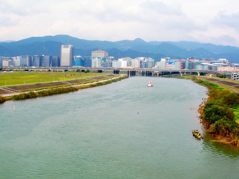
Photo courtesy of Wikimedia Commons
Prior to this calamity, the government had taken a passive approach to flood prevention in the city, building dykes, levees and other structures when needed. But the post-war population surge had greatly altered the Keelung River’s environment as people settled along its banks and built all sorts of illegal houses and factories.
Impervious to water, these structures made the river even more prone to flooding as they eliminated a buffer zone that excess water could flow into.
There was originally a quite comprehensive flood mitigation construction plan for the hardest-hit Shezidao (社子島) area, but the authorities ultimately chose to straighten the river by cutting off a bend that turned Shezidao from a sandbank to the peninsula it is today. This decision caused a stir at that time, and it proved ineffective. In just a few years, sediment was already building up in the new watercourse.

Photo courtesy of Wikimedia Commons
A second straightening project was launched in 1991 and completed in 1993, with a water-releasing ceremony held on Oct 30. This endeavor was also met with criticism, but then-mayor Huang Ta-chou (黃大洲) writes in his book Transformation: An Account of the Straightening of the Keelung River (改造: 基隆河截彎取直紀實) that it was also an urban renewal project as the new land in Dazhi and Neihu was immediately used for commercial and residential development. Huang was particularly proud that space was set aside for riverside parks.
The flooding still continued, however, and after Typhoon Nari caused another disaster in 2001, the government turned to other methods such as the Yuanshanzi Flood Diversion tunnel in today’s Ruifang District (瑞芳) near the river’s source.
SUDDEN CHANGE OF PLANS
Photo: Chien Jung-fong, Taipei Times
Chiang Tsung-ming’s (江聰明) book, Straightening: The Shezi Canal and Changes in the Lower Reaches of the Keelung River (截彎取直: 社子圳與基隆河下游之變遷) details the drama behind the first straightening endeavor.
The original plan was to remove the illegal structures along the banks, expand the flood area and construct embankments on both sides. A flood-diversion zone was to be established in the most severe area, as well as a new canal to further divert the water. But somehow, all of this was simplified into altering the river course.
Chiang writes that many rumors flew among Shezidao residents regarding the decision. One of them alleged that the straightening was done to move the river further away from then-president Chiang Kai-shek’s (蔣介石) residence in Shilin (today’s Shilin Residence). According to the tale, Chiang was furious after the storm battered the residence and ordered his staff to do all they could to prevent floods reaching it. The officials interpreted this as “move the river course away from the residence,” and hence the plan was altered. Chiang offers evidence that this story is unlikely.
Work to build dykes along the riverbanks had just started in March 1964 when the government abruptly ordered them to stop. Just nine days later, then-provincial governor Huang Chieh (黃杰) made an urgent report to the Executive Yuan about the new straightening proposal.
On March 14, the government announced its rationale: it would be hard to relocate the many houses and large factories along the banks in a short time; they lacked the earth needed to build the embankments, and also straightening the river would help water flow and was beneficial to future development.
The people didn’t really buy that — since when did the government need permission to demolish houses? Many suspected that the authorities just wanted to claim the estimated 143,000m2 of new land created by the rerouting. Others were convinced that wealthy factory owners had paid off the government so they wouldn’t have to move: under the new plan, only two out of the original 15 factories would have to relocate. Although also fewer residents along the banks would have to move, the construction would displace others and submerge productive farmland.
Despite vigorous local objection, the Executive Yuan approved the plan in September, and work began in November, bringing great changes to Shezidao. The old river course was supposed to turn into a drainage lake with recreational facilities, but that never happened due to planning and funding issues. The government eventually filled it up and in 1982 designated it as a special-use district for urban development.
SECOND EFFORT
One of the questions residents had during the 1964 rerouting was why the government didn’t tackle first the larger bends further upstream towards Neihu (內湖) and Nangang (南港). These bends were not only flood prone during the typhoon season, the sharp turns made it difficult to develop the area.
Huang Ta-chou writes in his book that ideally, the best way to mitigate floods was to expand and bolster the embankments in Neihu. But there were still about 12,000 residents living in illegal structures along the banks, and their lives would be threatened since they fell outside the protected area.
Times were different by the 1980s, and these residents refused to move, instead asking for permission to raise the height of their houses so they could seek refuge during floods. It would cost the city hundreds of millions of dollars to relocate them all, and location options were few in a rapidly expanding metropolis. Thus began talks to straighten the river again.
Planning proceeded slowly until Typhoon Lynn in 1985 caused another devastating flood. The problem was that few outside of the Taipei City Government seemed to like this plan, they found it more practical to boost funding and proactively train experts for more standard flood prevention methods.
The city shouldn’t be “fighting with the land for water,” urban development department head Tsai Hsun-hsiung (蔡勳雄) warned, noting that the river has historically been winding and human interference will cause more problems in the long run. Development plans for the new land also made people think that the city was doing it primarily for economic reasons. But after much debate, the straightening proposal was approved and construction began in November 1991.
“Although this method goes against nature’s principles, as long as we have complete supporting measures, we can minimize the damage and maximize our benefits,” Huang writes.
In addition to flood prevention and urban development, one of Huang’s major goals was to create more green recreational space for Taipei’s citizens. He recalls taking a boat through the river in 1987 and looking at the trash-strewn, foul-smelling shores that were being polluted by factories and pig farmers.
In his book he mentions that although green riverside parks were not the most economically beneficial and even slightly hampered flood mitigation functions, this part of the project was imperative so there could be more breathing space in a congested city.
Taiwan in Time, a column about Taiwan’s history that is published every Sunday, spotlights important or interesting events around the nation that either have anniversaries this week or are tied to current events.
April 14 to April 20 In March 1947, Sising Katadrepan urged the government to drop the “high mountain people” (高山族) designation for Indigenous Taiwanese and refer to them as “Taiwan people” (台灣族). He considered the term derogatory, arguing that it made them sound like animals. The Taiwan Provincial Government agreed to stop using the term, stating that Indigenous Taiwanese suffered all sorts of discrimination and oppression under the Japanese and were forced to live in the mountains as outsiders to society. Now, under the new regime, they would be seen as equals, thus they should be henceforth

Last week, the the National Immigration Agency (NIA) told the legislature that more than 10,000 naturalized Taiwanese citizens from the People’s Republic of China (PRC) risked having their citizenship revoked if they failed to provide proof that they had renounced their Chinese household registration within the next three months. Renunciation is required under the Act Governing Relations Between the People of the Taiwan Area and the Mainland Area (臺灣地區與大陸地區人民關係條例), as amended in 2004, though it was only a legal requirement after 2000. Prior to that, it had been only an administrative requirement since the Nationality Act (國籍法) was established in
Three big changes have transformed the landscape of Taiwan’s local patronage factions: Increasing Democratic Progressive Party (DPP) involvement, rising new factions and the Chinese Nationalist Party’s (KMT) significantly weakened control. GREEN FACTIONS It is said that “south of the Zhuoshui River (濁水溪), there is no blue-green divide,” meaning that from Yunlin County south there is no difference between KMT and DPP politicians. This is not always true, but there is more than a grain of truth to it. Traditionally, DPP factions are viewed as national entities, with their primary function to secure plum positions in the party and government. This is not unusual
US President Donald Trump’s bid to take back control of the Panama Canal has put his counterpart Jose Raul Mulino in a difficult position and revived fears in the Central American country that US military bases will return. After Trump vowed to reclaim the interoceanic waterway from Chinese influence, US Defense Secretary Pete Hegseth signed an agreement with the Mulino administration last week for the US to deploy troops in areas adjacent to the canal. For more than two decades, after handing over control of the strategically vital waterway to Panama in 1999 and dismantling the bases that protected it, Washington has