Sweeping statement time: the westernmost section of the Batongguan Historic Trail (八通關古道) in Nantou County is hands down one of Taiwan’s finest day hikes (and there are hot springs to enjoy afterwards to boot). Very few other trails in Taiwan command such incredible views for so little effort. Quite simply, it’s one hike everyone should try to do once, although compared with other classic day hikes, such as the overrated Caoling Historic Trail (草嶺古道) in New Taipei City, remarkably few do.
Recent upgrades to this part of the historic trail have made it safe and easy for hikers of all abilities to follow, but it has a long and interesting history. The trail dates back to the Qing dynasty. Even after Qing rulers annexed Taiwan in 1683, the island was for a long time considered of little importance, even being famously described as “a ball of mud” by the Kangxi emperor (reigned 1661-1722).
VIOLENT HISTORY

Photo: Richard Saunders
After Han settlement started increasing in the early 1700s, immigrants occupied the fertile western plains, forcing the island’s indigenous inhabitants into the mountains. Despite efforts to keep the island’s Han and Aboriginal peoples apart, conflicts occurred. Things came to a head with the killing in 1871 of over 50 Japanese sailors by Paiwan Aborigines, in what became known as the Mudan Incident (牡丹社事件).
The Qing government (as it turned out only-too-rightly fearful of incursions by Japan, under the pretense of punishing the offenders) set about placating the Japanese by opening up the island’s inaccessible interior and suppressing the Aboriginal inhabitants. The original Batongguan Trail was the longest of the three cross-island routes established to provide access to the north, center and south of the island’s interior. These new communication routes managed to keep the Aborigines in check to an extent, but two decades later, Japan still found an excuse to colonize the island.
The original trail stretched 152km and was apparently completed by 2,000 soldiers in the amazing space of just one year. The trail that we follow today, correctly known as the Batongguan Traversing Trail (八通關越嶺古道) is a later construction, built by the Japanese between 1919 and 1921 for the same reason — to subjugate the Aboriginal inhabitants. Leaving the hotspring town of Dongpu (東埔), the two routes are largely the same, but further east they diverge quite widely.

Photo: Richard Saunders
HIKING THE TRAIL
Start out at Dongpu Hot Springs (東埔溫泉), an area of hotels and modest resorts perched on the side of a deep valley below the looming peaks of the Yushan Mountain Range (玉山山脈). It’s a comfortable place to spend the night, and although the walk can be completed in half a day, it’s worth spending the night before in Dongpu and setting off early the following morning, when the weather is more likely to be clear.
The three-hour walk from Dongpu village to Yinu Waterfall (乙女瀑布) begins with a short road walk up the main street through the hot spring resort. Pass through a tunnel, ignore the old trailhead on the left, which has now been closed, and walk another five minutes to the start of the path, a steep concrete lane marked by an info board.

Photo: Richard Saunders
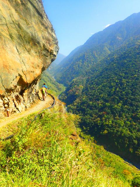
The lane climbs stiffly at first, giving a panoramic view over Dongpu, the river valley below and (rising behind) the summits of Yushan Front (玉山前峰; 3,239 meters) and West (玉山西峰3,518 meters) peaks. After an area of snack stands (which set up daily beside the trail) the route climbs around the side of the crumbling, slippery face of Father & Son Cliff (父不知子斷崖).
Back in the 1990s, on my first visit, this was still a particularly precarious stretch of the trail, cut into the sheer rock face. Much improved after being nearly destroyed by Typhoon Morakot in 2009, the trail is wide and safe, with rugged iron tube barriers to dissuade the careless from falling over the brink.
CLOUD DRAGON WATERFALL
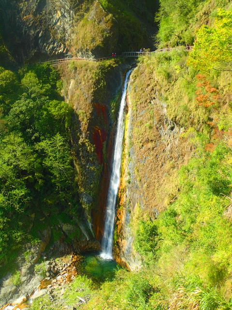
From here to Cloud Dragon Waterfall (雲龍瀑布), much of the trail is cut into the sheer cliff, with a breathtaking drop into the gorge far, far below, punctuated by short sections where the mountain gradient becomes gentle enough to support pockets of forest. Four kilometers (about two hours) from the trailhead, Cloud Dragon Waterfall plunges in two spectacular leaps, both invisible from the trail until the last moment. The upper fall can be enjoyed from the bridge across the stream below. To see the much higher and more spectacular lower fall, walk to the suspension bridge, another hundred meters or so further.
After Cloud Dragon Waterfall, the trail disappears into the woods, the terrain becomes less precipitous and there are only occasional views over the great gorge below. Paradoxically, though, the hiking becomes a bit more taxing. About 40 minutes past the waterfall, the trail passes a trekkers’ shelter called Lele Cabin (樂樂山屋), standing on the site of a former Japanese police substation.
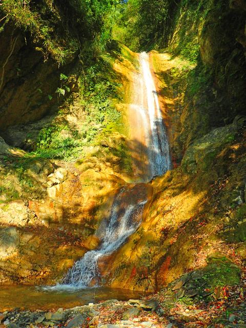
Beyond the hut the trail soon emerges from the trees, and there are views across to a stream plunging in multiple cascades down the mountainside at Yinu Waterfall (about six kilometers from the trailhead). The trail crosses the stream by an iron footbridge just below a particularly fine fall in the series; the rocky scree at its base is a great place to stop, relax and enjoy the beauty of the scene before contemplating the walk back to Dongpu.
Beyond Yinu Waterfall, the Batongguan Trail continues to climb to Guangao (觀高). For day trippers, though, the best is over (and you definitely need permits to go any further), so turn round and start the walk back to Dongpu.
There-and-back walks almost never finish as well as they start, but with a whole new set of panoramas unfolding on the return journey, the walk back this time is every bit as enjoyable as the outward route. Just hope for clear weather.
Richard Saunders is a classical pianist and writer who has lived in Taiwan since 1993. He’s the founder of a local hiking group, Taipei Hikers, and is the author of six books about Taiwan, including Taiwan 101 and Taipei Escapes. Visit his Web site at www.taiwanoffthebeatentrack.com.

US Indo-Pacific Commander Admiral Samuel Paparo, speaking at the Reagan Defense Forum last week, said the US is confident it can defeat the People’s Republic of China (PRC) in the Pacific, though its advantage is shrinking. Paparo warned that the PRC might launch a “war of necessity” even if it thinks it could not win, a wise observation. As I write, the PRC is carrying out naval and air exercises off its coast that are aimed at Taiwan and other nations threatened by PRC expansionism. A local defense official said that China’s military activity on Monday formed two “walls” east

The latest military exercises conducted by the People’s Liberation Army (PLA) last week did not follow the standard Chinese Communist Party (CCP) formula. The US and Taiwan also had different explanations for the war games. Previously the CCP would plan out their large-scale military exercises and wait for an opportunity to dupe the gullible into pinning the blame on someone else for “provoking” Beijing, the most famous being former house speaker Nancy Pelosi’s visit to Taiwan in August 2022. Those military exercises could not possibly have been organized in the short lead time that it was known she was coming.

The world has been getting hotter for decades but a sudden and extraordinary surge in heat has sent the climate deeper into uncharted territory — and scientists are still trying to figure out why. Over the past two years, temperature records have been repeatedly shattered by a streak so persistent and puzzling it has tested the best-available scientific predictions about how the climate functions. Scientists are unanimous that burning fossil fuels has largely driven long-term global warming, and that natural climate variability can also influence temperatures one year to the next. But they are still debating what might have contributed to this

For the authorities that brought the Mountains to Sea National Greenway (山海圳國家綠道) into existence, the route is as much about culture as it is about hiking. Han culture dominates the coastal and agricultural flatlands of Tainan and Chiayi counties, but as the Greenway climbs along its Tribal Trail (原鄉之路) section, hikers pass through communities inhabited by members of the Tsou Indigenous community. Leaving Chiayi County’s Dapu Village (大埔), walkers follow Provincial Highway 3 to Dapu Bridge where a sign bearing the Tsou greeting “a veo veo yu” marks the point at which the Greenway turns off to follow Qingshan Industrial Road (青山產業道路)