It was exactly a century-and-a-half ago, in 1867, that Chinese military ambassador Liu Ming-deng (劉明燈) set off to inspect one of the Taiwan’s newest and most important communication routes.
It was a different world then, of course. Today an inspection would perhaps involve a high-ranking politician taking an inaugural trip on a new Taipei MRT line, accompanied by crowds of camera-toting reporters.
THE OLD DAYS ON DANLAN
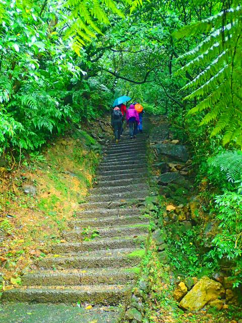
Photo: Richard Saunders
Back in the 1860s though, there were no trains of any kind, and no roads either, so Liu’s inspection tour meant a grueling walk of what must have been several days, taking in a section of the crucial Danlan Old Trail (淡蘭古道), which connected Tamsui with the fertile but then hard-to-reach Lanyang Plain (蘭陽平原) in today’s Yilan County.
During his walk, Liu, who was regional commander of China’s military on Taiwan, encountered various hardships, ranging from sickness (the flu) to terrible weather. It seems that people were made of sterner stuff in those days, however, and rather than retreat to lower altitudes when the weather turned nasty (as it so often does in that area of the country), Liu faced the difficulties head on.
At one point, in an attempt to dispel strong gales that were making progress difficult, it is said he brandished a stick dipped in mud, and with a florid movement wrote the character for tiger (虎) on a boulder beside the path. That boulder (and another, much larger inscription a few minutes further along the trail) are now the main attraction (with great views and a magnificent display of blooming silver grass each November and December) along the stretch of the Danlan Old Trail now known as the Caoling Mountain Pass (草嶺古道).
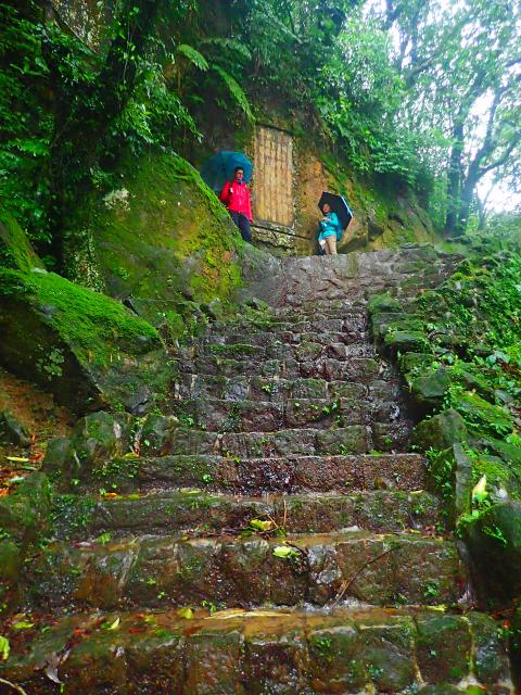
Photo: Richard Saunders
Nowadays, the scenic but often crowded Caoling Mountain Pass is one of the few parts of the Danlan Old Trail that can still be followed, but it’s not the only surviving section of the route. Thanks to a resurgence of interest in Taiwan’s historical heritage in recent years, several sections of the route have been rediscovered and opened for us to retrace, in our leisure, the steps countless long-gone Aborigines and Taiwanese must have trudged a century and more ago.
Three other, less well-known sections of the old route can be followed, all in its southern half. First, the Longling Old Trail (隆嶺古道) is the earliest part of the Danlan Old Trail to be established, and was already being used in 1807. Like the Caoling Mountain Pass, it crosses the mountains of Sandiaojiao (三貂角), in New Taipei City. It’s a short but fairly rough walk, and a good indicator of what the parallel trail might have been like before it was discovered by the masses.
The two other remaining sections of the Danlan Old Trail have, like the Caoling Mountain Pass, both been developed by local authorities for the average walker. First is a short (2km) length of trail following the bank of the Wutu Stream (烏塗溪) from Shiding (石碇) downstream to Provincial Route 106. Most visitors to Shiding are either there to enjoy the town’s famous tofu or to hike the wonderful Huangdidian (皇帝殿) or Bijia Mountain (筆架山) ridges, but this short length of Danlan Old Trail is worth a stroll, despite being accompanied by the elevated carriageways of a freeway for part of its length.
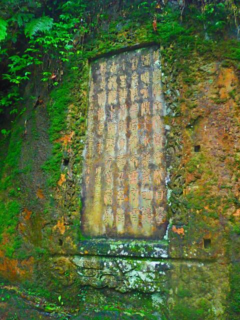
Photo: Richard Saunders
‘GOLDEN LETTERS TABLET’
The last surviving section of the Danlan Old Trail that can be easily followed today is usually known after the main landmark on the route, the third of those impressive inscribed stones carved on the orders of Liu Ming-deng during his eventful survey of the trail in 1867, the Golden Letters Tablet (金字碑).
The trail to the Golden Letters Tablet is a one-hour walk (signposted) from Houtong Train Station in New Taipei City’s Ruifang District (瑞芳), but hikers with their own transport can reach it via the far shorter route from the east, leaving Provincial Road 102 about 7km south of the gold mining village of Jiufen (九份).
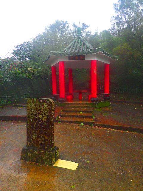
Photo: Richard Saunders
Look for an info board beside the road on the right. It’s a short climb up the wooded hillside to a low saddle on the ridge, paved with an ugly expanse of concrete, and an ornamental rest shelter.
In front of the shelter is a well-weathered stone tablet, which looks rather like a tombstone. It is in fact one of Taiwan’s earliest surviving examples of ecological awareness, dating from the same time as the Golden Letters Tablet nearby, and elaborately engraved with calligraphy (now badly eroded) requesting that travelers resting on this spot don’t remove (for firewood) the shade-giving trees that once covered the area.
Follow the steps down the far side of the ridge, and in about five minutes a low outcrop of dark sandstone rises above the path on the left. Carved into its face is an elaborate inscription in the form of a rectangular plaque about two meters high by one wide. This impressive monument is an inscription (originally highlighted in gold, hence the name) etched into the natural rock face on the command of Liu during his 1867 journey.
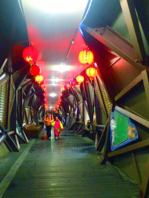
Photo: Richard Saunders
The verses, in classical Chinese basically implores visitors to enjoy the natural beauty of the scene (“…high and low, watercourses crash like thunder…”), yet be prepared to defend the region from aggression (“…prepare for the future by polishing weapons and recruiting soldiers”).
It’s tough for today’s visitors, with the benefit of modern roads, motorized transport and upgraded paths, to get more than the vaguest feelingfor just how remote this spot would have been when Liu and his retinue passed through a century and a half ago, yet perhaps it’s still possible, within this deep, thick, unspoiled forest, to imagine weary travelers pausing at this impressive monument, resting a moment to read its elegant lines and then passing on their way.
Richard Saunders is a classical pianist and writer who has lived in Taiwan since 1993. He’s the founder of a local hiking group, Taipei Hikers, and is the author of six books about Taiwan, including Taiwan 101 and Taipei Escapes. Visit his Web site at www.taiwanoffthebeatentrack.com.

What was the population of Taiwan when the first Negritos arrived? In 500BC? The 1st century? The 18th? These questions are important, because they can contextualize the number of babies born last month, 6,523, to all the people on Taiwan, indigenous and colonial alike. That figure represents a year on year drop of 3,884 babies, prefiguring total births under 90,000 for the year. It also represents the 26th straight month of deaths exceeding births. Why isn’t this a bigger crisis? Because we don’t experience it. Instead, what we experience is a growing and more diverse population. POPULATION What is Taiwan’s actual population?

For the past five years, Sammy Jou (周祥敏) has climbed Kinmen’s highest peak, Taiwu Mountain (太武山) at 6am before heading to work. In the winter, it’s dark when he sets out but even at this hour, other climbers are already coming down the mountain. All of this is a big change from Jou’s childhood during the Martial Law period, when the military requisitioned the mountain for strategic purposes and most of it was off-limits. Back then, only two mountain trails were open, and they were open only during special occasions, such as for prayers to one’s ancestors during Lunar New Year.

You would never believe Yancheng District (鹽埕) used to be a salt field. Today, it is a bustling, artsy, Kowloon-ish “old town” of Kaohsiung — full of neon lights, small shops, scooters and street food. Two hundred years ago, before Japanese occupiers developed a shipping powerhouse around it, Yancheng was a flat triangle where seawater was captured and dried to collect salt. This is what local art galleries are revealing during the first edition of the Yancheng Arts Festival. Shen Yu-rung (沈裕融), the main curator, says: “We chose the connection with salt as a theme. The ocean is still very near, just a

A key feature of Taiwan’s environmental impact assessments (EIA) is that they seldom stop projects, especially once the project has passed its second stage EIA review (the original Suhua Highway proposal, killed after passing the second stage review, seems to be the lone exception). Mingjian Township (名間鄉) in Nantou County has been the site of rising public anger over the proposed construction of a waste incinerator in an important agricultural area. The township is a key producer of tea (over 40 percent of the island’s production), ginger and turmeric. The incinerator project is currently in its second stage EIA. The incinerator