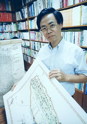
When a story about the formation of Taiwan's first map-collectors' club hit the pages of local newspapers last month, the club's founder, Wei Te-wen (
As general manager of SMC Publishing (
Instead of focusing on any of these issues, however, the offending newspaper article concerned itself with the monetary value of many of the maps and charts. The report gave great play to the fact that some of the Antique Map Club's (

PHOTO COURTESY OF WEI TE-WEN
Wei and the geographers, scholars, teachers and students in the map-collectors' club felt the article had completely missed the mark. They insist the club's aim is to elevate the understanding of maps and increase people's awareness of their usefulness, and not an eccentric, pricey hobby.
Wei believes that underexposure to maps and their usage is one of the reasons a large number of people in Taiwan are directionally challenged. According to Wei it's not uncommon for people to be unaware in which direction north, south, east or west lie in relation to their present location.
"It's safe to say that Taiwan is a nation unable to read maps. If I went to Roosevelt Road and asked a dozen or so people directions only one or two would be able to tell me which way I need to go," says Wei.

"And even then, hardly anyone would use north, south, east or west in their explanations."
According to Tang Chia-ching (
"Map reading was never taught in schools, and the geography that was taught in school was about China rather than Taiwan. I'd say over 80 percent of what was taught in schools had nothing to do with Taiwan until the late 1980s when Taiwan's geography was included on the curriculum," Tang said.

PHOTO COURTESY OF WEI TE-WEN
Lien Feng-tsong (
"It might sound grim, but after the 921 earthquake a lot more students began to take an active interest in geography," states Lien. "And it's not just the earthquake. When typhoons hit, interest rises and so on. It's as if it takes forces of nature to get people interested in the environment and the place in which they live, rather than people having a natural interest in the place they live."
Wei, however, is convinced that people's difficulty with cardinal directions predates the martial law era. The entire history of the mapping of Taiwan and its outlying islands does, according to Wei, lend itself to this current state of affairs. Lack of interest by the people who lived in Taiwan and who governed the island has been a factor throughout history.

PHOTO: JEROME FAVRE
Mapmakers in China were aware of Taiwan's geographical position in relation to Fujian Province as early as 250AD, but the island was not deemed important enough to be included on maps until the mid-1600s. It would be another 300 years before Taiwan was considered important enough to map in its entirety. And to really confound the situation, a vast majority of this work was undertaken by foreigners.
"As Taiwan wasn't considered part of China, early Chinese cartographers used to leave it off. Obviously no one could have given a tiny spot any detail because no body trained to do so came here," Wei said. "The Portuguese, in fact, were the first people to include Taiwan on a map in the mid-1500s, almost 100 years before the Chinese did so."
The first map ever to include Taiwan was a map of Southeast China and the Philippines drawn by Portuguese mapmaker Lopo Hemem, in 1554. Far from looking like a sweet potato, the island, of which there is no detail, looks more like a banana. Next came the Spanish. From between 1571 and 1597 they sailed closer to Taiwan than their Iberian rivals and set about charting both the east and west coasts.
Getting the picture
It wasn't until the early 1600s, however, that Taiwan's outlying islands and hinterland became the focus for mapmakers. Only this time the foreign cartographers hailed from the Netherlands.
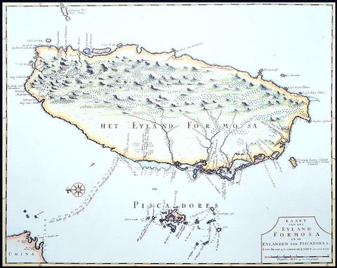
"The Dutch who occupied Taiwan Fu [present day Tainan] began mapping the surrounding area in 1624, the same year that an expedition began to map the Pescadores [present-day Penghu]," Wei said. "And then the following year Taiwan first appeared on a Dutch map bearing a semblance to the shape we know it to be today."
Before the Dutchman J.I. Noordeloos published his map in 1625, Taiwan had appeared in an odd assortment of shapes and sizes on European maps. The oddest of all being that of Dutch explorer, Willem Blaeu, who in 1600 managed to map Taiwan as three huge individual islands.
While Noordeloos' representation of Taiwan was the nearest any cartographer had gotten to the real outline of the island, with the exception of a few towns on the west and northern coastlines there was little detail. Expeditions into the hinterland were considered worthless ventures.
During this time, the Chinese joined the effort to map Taiwan. Between 1684 to 1895 countless maps of Taiwan were published, the most famous of which is the Qianlung Taiwan Map (
While there is some doubt as to the exact age of the 7m scroll map, scholars believe it to date from the early 1700s. From where the central mountain range begins rising from the plains on the west coast, however, the map turns into blank space.
"Nobody cared what went on there. People knew that tribes lived somewhere in the mountains, but no one wanted to go. The entire western side of the island was considered worthless by everyone," Wei said. "The Dutch and Portuguese left the east alone. The Spanish partially mapped the location of several large estuaries. And the Chinese? Well, to them, the eastern side of Taiwan was a wild land full of savages, so they certainly didn't have interest in exploring the area."
It was to be the French who were the first to add any detail to maps of Taiwan's east coast. Explorer Nicolas Bellin set out to map the estuaries, rivers and streams of the area around present-day Hualien in 1765.
Over 100 years later a Japanese expedition into the central mountain range would be the first to map and locate Aboriginal settlements. Three thousand Japanese soldiers and a handful of military mapmakers were given permission by Ching authorities, which still had little interest in the central and eastern parts of the island, to cross the island in 1871, 24 years before Taiwan was ceded to Japan.
While the Japanese expedition set out under the guise of a mapping expedition, the heavily armed troops were in fact under orders to seek and destroy any hostile natives they encountered. A map was produced, however. And by 1878 the Japanese military was in possession of a map that detailed native settlements and mountain trails from Tainan eastward across the southern tip of the central mountain range to Taitung.
Upon gaining control of Taiwan in 1895 the Imperial Japanese Army set about mapping the entire island in earnest. Not that troops dispatched to chart the island's still wild hinterland were solely occupied with mapmaking. The mapping of Taiwan's central mountains and east coast was a bloody affair. Between 1895 and 1945 countless expeditions were launched and thousands of Aborigines were butchered by the Imperial Japanese mapmakers.
Although the Japanese became the first to amass a fairly accurate set of charts by the early 1940s, the data for most of these were accumulated by sending foot soldiers to explore the unmapped territories. Modern mapping techniques were left to the US Air Force. From 1943 until Japan's surrender in 1945 it was the turn of the US to map Taiwan. This time, however, the charting caused no bloodshed, as the US Air Force charted the entire island using the latest in aerial photography.
Military takes over
"The US was the first nation to use modern technology to map Taiwan. During the war the data were used to chart Japanese defensive positions and bombing targets. Upon the arrival of the ROC on Taiwan the information and data needed to compile detailed maps of Taiwan were handed over to the local military by US forces," Wei said.
And it's there that aerial photographs and, more recently, satellite imagery remained. Much of the data was considered vital to national security. Private citizens were not allowed access to any of this information until 1987.
According to Tang, there are now well over 1,000 publishing houses in Taiwan producing maps of one kind or another. Not that he has much faith in many of the maps produced.
"In France you have the world-famous and highly respected Michelin maps. There' s no such thing in Taiwan. Anyone with a printer can knock out a map and sell it. Which is what has happened," says Lien. "I don't know how people can use many of them. If you look at the tourist maps they're covered in pretty pictures and look colorful, but as reliable sources of direction they're utterly useless."
It's not only a question of quality that has mapmakers such as Tang and Lien up in arms. Copyright infringements in the mapmaking world are rife. While trustworthy companies purchase aerial photos from the Forestry Bureau (林務局) and satellite imagery from National Central University (國立中央大學) many of the maps on bookstore shelves are illegally produced.
While Tang has reservations about many of maps produced in Taiwan he has nothing but praise for the island's most assiduous mapmakers, the Forestry Bureau.
Since martial law was lifted, it has been the job of the bureau to map the entire island, a task that is undertaken ever five years. With the exception of the military, the bureau has the most up-to-date and comprehensive database of maps of Taiwan.
Although the bureau receives few requests from private individuals for maps, many are in fact readily available for private use free of charge. People planning a long jaunt into the central mountain range are advised to get their maps from the bureau rather than anywhere else, as hundreds of people get lost every year because of the many low-quality tourist maps of Taiwan's wilderness.
As for when the multitudes of Taiwan's directionally challenged will one day be able to give comprehensive directions, that day will come sooner rather than later if Tang's association has its way.
The Chinese Taipei Society of Photogrammetry & Remote Sensing is at present holding talks with the Ministry of Education to consider setting up programs within schools. It is hoped that the programs will at least give students a basic knowledge of their whereabouts.

Dec. 16 to Dec. 22 Growing up in the 1930s, Huang Lin Yu-feng (黃林玉鳳) often used the “fragrance machine” at Ximen Market (西門市場) so that she could go shopping while smelling nice. The contraption, about the size of a photo booth, sprayed perfume for a coin or two and was one of the trendy bazaar’s cutting-edge features. Known today as the Red House (西門紅樓), the market also boasted the coldest fridges, and offered delivery service late into the night during peak summer hours. The most fashionable goods from Japan, Europe and the US were found here, and it buzzed with activity

US Indo-Pacific Commander Admiral Samuel Paparo, speaking at the Reagan Defense Forum last week, said the US is confident it can defeat the People’s Republic of China (PRC) in the Pacific, though its advantage is shrinking. Paparo warned that the PRC might launch a “war of necessity” even if it thinks it could not win, a wise observation. As I write, the PRC is carrying out naval and air exercises off its coast that are aimed at Taiwan and other nations threatened by PRC expansionism. A local defense official said that China’s military activity on Monday formed two “walls” east

The latest military exercises conducted by the People’s Liberation Army (PLA) last week did not follow the standard Chinese Communist Party (CCP) formula. The US and Taiwan also had different explanations for the war games. Previously the CCP would plan out their large-scale military exercises and wait for an opportunity to dupe the gullible into pinning the blame on someone else for “provoking” Beijing, the most famous being former house speaker Nancy Pelosi’s visit to Taiwan in August 2022. Those military exercises could not possibly have been organized in the short lead time that it was known she was coming.

The world has been getting hotter for decades but a sudden and extraordinary surge in heat has sent the climate deeper into uncharted territory — and scientists are still trying to figure out why. Over the past two years, temperature records have been repeatedly shattered by a streak so persistent and puzzling it has tested the best-available scientific predictions about how the climate functions. Scientists are unanimous that burning fossil fuels has largely driven long-term global warming, and that natural climate variability can also influence temperatures one year to the next. But they are still debating what might have contributed to this