The European Central Bank (ECB) warned on Monday that increased financial regulation could lead to other kinds of risk-taking that officials will have to keep in their sights.
Responses by banks and other financial institutions to measures aimed at preventing future crises will have to be followed carefully, “and attention must be directed to detect new risks that may emerge from the reaction to the new regulations,” ECB Vice President Vitor Constancio told a conference in Frankfurt, Germany.
“For instance, the increase in the cost of capital may lead to strategies by financial institutions, to more risky activities and projects or to the creation of new types of non-regulated entities to conduct financial business,” he said.
“The perimeter of regulated institutions risks becoming a sort of moving target,” Constancio said.
Authorities worldwide have been pressed to tighten oversight of banks, insurers, hedge funds, brokers and private equity funds, among others, to ensure that taxpayers are not forced to back more massive bailouts like those seen since in 2007 and 2008.
Banks counter that increased regulations will force them to curb lending to the wider economy, a crucial element in ensuring an uncertain recovery does not falter.
Constancio reminded the academics and central bank officials gathered in Germany’s financial capital that some major changes lay ahead.
“The general overhaul of regulation that has been recently decided or is being prepared has far-reaching implications from the point of view of macro-prudential policy,” he said.
“The increase of capital and liquidity requirements, the limits to leverage, the new framework to deal with derivatives, the measures to address the problem of institutions ‘too big to fail’ either through higher loss absorption capacity or better resolution schemes — are all measures that contain important elements responding to macro-prudential concerns,” he said.

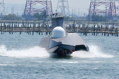
ENDEAVOR MANTA: The ship is programmed to automatically return to its designated home port and would self-destruct if seized by another party The Endeavor Manta, Taiwan’s first military-specification uncrewed surface vehicle (USV) tailor-made to operate in the Taiwan Strait in a bid to bolster the nation’s asymmetric combat capabilities made its first appearance at Kaohsiung’s Singda Harbor yesterday. Taking inspiration from Ukraine’s navy, which is using USVs to force Russia’s Black Sea fleet to take shelter within its own ports, CSBC Taiwan (台灣國際造船) established a research and development unit on USVs last year, CSBC chairman Huang Cheng-hung (黃正弘) said. With the exception of the satellite guidance system and the outboard motors — which were purchased from foreign companies that were not affiliated with Chinese-funded

PERMIT REVOKED: The influencer at a news conference said the National Immigration Agency was infringing on human rights and persecuting Chinese spouses Chinese influencer “Yaya in Taiwan” (亞亞在台灣) yesterday evening voluntarily left Taiwan, despite saying yesterday morning that she had “no intention” of leaving after her residence permit was revoked over her comments on Taiwan being “unified” with China by military force. The Ministry of the Interior yesterday had said that it could forcibly deport the influencer at midnight, but was considering taking a more flexible approach and beginning procedures this morning. The influencer, whose given name is Liu Zhenya (劉振亞), departed on a 8:45pm flight from Taipei International Airport (Songshan airport) to Fuzhou, China. Liu held a news conference at the airport at 7pm,

GRIDLOCK: The National Fire Agency’s Special Search and Rescue team is on standby to travel to the countries to help out with the rescue effort A powerful earthquake rocked Myanmar and neighboring Thailand yesterday, killing at least three people in Bangkok and burying dozens when a high-rise building under construction collapsed. Footage shared on social media from Myanmar’s second-largest city showed widespread destruction, raising fears that many were trapped under the rubble or killed. The magnitude 7.7 earthquake, with an epicenter near Mandalay in Myanmar, struck at midday and was followed by a strong magnitude 6.4 aftershock. The extent of death, injury and destruction — especially in Myanmar, which is embroiled in a civil war and where information is tightly controlled at the best of times —

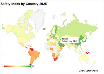
Taiwan was ranked the fourth-safest country in the world with a score of 82.9, trailing only Andorra, the United Arab Emirates and Qatar in Numbeo’s Safety Index by Country report. Taiwan’s score improved by 0.1 points compared with last year’s mid-year report, which had Taiwan fourth with a score of 82.8. However, both scores were lower than in last year’s first review, when Taiwan scored 83.3, and are a long way from when Taiwan was named the second-safest country in the world in 2021, scoring 84.8. Taiwan ranked higher than Singapore in ninth with a score of 77.4 and Japan in 10th with