Wall Street has stepped back from a spectacular six-month rally, leaving investors pondering the depth of the latest pullback in the context of a fragile economic recovery.
Some analysts say a “correction” would be healthy for the market by working off some of the gains and easing speculative fervor from short-term traders.
Still in doubt, however, is whether the bull market can keep running even after stunning gains of some 60 percent for the broad market as the economy struggles to emerge from recession.

Over the past week, the Dow Jones Industrial Average lost 1.58 percent to end Friday at 9,665.19, as the market pulled back from 11-month highs.
The tech-dominant NASDAQ slipped 1.97 percent to 2,090.92 while the Standard & Poor’s 500 broad-market index retreated 2.24 percent to 1,044.38.
The market appeared to hit a roadblock on Wednesday as stocks rallied in the wake of a Federal Reserve announcement that it intended to hold interest rates near zero for some time.
The rally pushed the Dow briefly above 9,900 but then a pullback began. Analysts said the market used the occasion to lock in hefty gains and wait for further evidence that the economy is pulling out of recession.
Al Goldman, chief market strategist at Wells Fargo Advisors, urged clients to wait out the correction.
“A several-day pullback has begun,” he said. “We believe it will be measured in days, not weeks, but it still must be respected after the 60 percent rally from the March 9 lows. The big picture is still a bull market which we believe will be higher by year-end.”
Bob Dickey at RBC Wealth Management said the market is in “an established bull trend” until proven otherwise.
“Today the market is likely telling us what the economic condition may be six to 12 months from now, and although it currently may not make sense, the market has tended to lead these economic changes historically,” he said.
Gregory Drahuschak at Janney Montgomery Scott said that “for the very short-term that the market is getting a bit tired” but that does not alter the long-term outlook.
“We are not concerned about a short-term pullback since we are focused more on GDP and earnings potential into the first half of 2010 — potential we do not think the market has discounted fully yet,” he said.
Also optimistic was John Praveen at Prudential International Investments, saying: “Equity markets are now facing the sweet spot in the economic cycle with a stronger and faster rebound from the recession, inflation close to a trough, but not yet picking up enough to cause concern, ample liquidity and interest rates remaining low.”
Others remained skeptical, including David Rosenberg, chief economist and strategist at Gluskin Sheff & Associates.
Rosenberg said he saw “a bear market rally as opposed to the onset of a new secular bull market” and urged investors to stay cautious.
“I am always skeptical of rallies that are purely premised on technicals and liquidity but bereft of a solid economic foundation,” he said. “While green shoots did appear in the economic data, all the growth we have seen globally, and in the USA in particular, has come courtesy of unprecedented government stimulus. We see nothing organically in the economy to get us excited.”
Bonds firmed as investors shifted away from equities. The yield on the 10-year Treasury bond eased to 3.329 percent from 3.474 percent a week earlier while that on the 30-year bond dropped to 4.093 percent from 4.231 percent.

DETERRENCE: With 1,000 indigenous Hsiung Feng II and III missiles and 400 Harpoon missiles, the nation would boast the highest anti-ship missile density in the world With Taiwan wrapping up mass production of Hsiung Feng II and III missiles by December and an influx of Harpoon missiles from the US, Taiwan would have the highest density of anti-ship missiles in the world, a source said yesterday. Taiwan is to wrap up mass production of the indigenous anti-ship missiles by the end of year, as the Chungshan Institute of Science and Technology has been meeting production targets ahead of schedule, a defense official with knowledge of the matter said. Combined with the 400 Harpoon anti-ship missiles Taiwan expects to receive from the US by 2028, the nation would have

North Korea yesterday fired about 10 ballistic missiles to the sea toward Japan, the South Korean Joint Chiefs of Staff (JCS) said, days after Pyongyang warned of “terrible consequences” over ongoing South Korea-US military drills. Pyongyang recently dashed hopes of a diplomatic thaw with Seoul, Washington’s security ally, describing its latest peace efforts as a “clumsy, deceptive farce.” Seoul’s military detected “around 10 ballistic missiles launched from the Sunan area in North Korea toward the East Sea [Sea of Japan] at around 1:20pm,” JCS said in a statement, referring to South Korea’s name for the body of water. The missiles

‘UNWAVERING FRIENDSHIP’: A representative of a Japanese group that co-organized a memorial, said he hopes Japanese never forget Taiwan’s kindness President William Lai (賴清德) yesterday marked the 15th anniversary of the Tohoku earthquake and tsunami, urging continued cooperation between Taiwan and Japan on disaster prevention and humanitarian assistance. Lai wrote on social media that Taiwan and Japan have always helped each other in the aftermath of major disasters. The magnitude 9 earthquake struck northeastern Japan on March 11, 2011, triggering a massive tsunami that claimed more than 19,000 lives, according to data from Japanese authorities. Following the disaster, Taiwan donated more than US$240 million in aid, making it one of the largest contributors of financial assistance to Japan. In addition to cash donations and

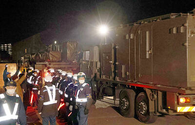
CLOSER TO CHINA: The upgraded Type-12 missile has a range of about 1,000km, compared with the original model’s range of 200km, and can reach mainland China Japan is preparing to deploy its first batch of domestically developed long-range missiles, with their launchers arriving at an army camp yesterday, as the country accelerates its offensive capability in response to rising challenges in the region. The upgraded Type-12 land-to-ship missiles are to be deployed at Camp Kengun in Japan’s southwestern prefecture of Kumamoto by the end of this month, completing the process of deployment, Japanese Chief Cabinet Secretary Minoru Kihara said without giving details. Army vehicles carrying the launchers and other equipment arrived past midnight in a highly secretive mission criticized by residents. Dozens of people stood outside of the