As Beijing locks horns with a number of countries over the islands and waters of the East and South China Sea, China has launched a program to greatly increase its remote-sensing capabilities through the use of unmanned aerial vehicles (UAV), reports said yesterday.
The State Council last year approved a 10-year “national marine zoning” program to establish integrated, three dimensional, high-precision monitoring of China’s maritime areas. As part of China’s 12th five-year plan, which runs through to 2015, the State Oceanic Administration has been ordered to increase its remote-sensing capabilities through the acquisition and deployment of UAVs, pilot training and the construction of support infrastructure, Xinhua news agency reported.
In addition to increased surveillance of coastal waters, the UAVs are to also monitor waters under Chinese jurisdiction — including the Scarborough Shoal (Huangyan Island, 黃岩島), the Paracel Islannds (Xisha Islands, 西沙群島) and the Spratly (Nansha Islands, 南沙群島) archipelago in the South China Sea — over which China has engaged in territorial disputes with a number of neighboring states including Taiwan, Vietnam and the Philippines.
According to the report, the UAVs are also to be used to conduct surveillance near the Diaoyutai Islands (釣魚台) in the East China Sea — the object of an escalating dispute since Sept. 11 after the Japanese government announced the purchase of three of the islets comprising the potentially resource-rich archipelago. Taiwan, Japan and China all claim sovereignty over the islets.
Although China already uses space-based sensors to monitor its waters, UAVs provide much greater mobility and precision (down to 0.1m), and can loiter over a targeted area providing constant and real-time imaging. This is a major advantage over space orbiters, which, because of their altitude can only scan the same location every two or three days, thus minimizing the effective monitoring of fixed and moving targets.
At present, China relies mostly on satellites and manned aircraft to conduct maritime surveillance.
Japanese media reported last month that the US had agreed to use some of its Northrop Grumman RQ-4 Global Hawk drones — deployed at Andersen Air Force Base on Guam since September 2010 — to conduct surveillance over parts of Japanese territory and near the Diaoyutais, known as the Senkakus in Japan.
In recent years the Chinese military as well as law enforcement agencies have acquired and developed a number of unmanned vehicles, including fixed-wing aircraft and helicopters. The People’s Liberation Army Navy, and civilian maritime safety agencies, have also worked to actively integrate ship-based UAVs to their operations.
In related news, images released by Xinhua on Saturday indicated that J-10B and Sukhoi Su-30 all-weather combat aircraft had been dispatched to augment forces operating in the East China Sea Fleet.
This development occurs as the East China Sea Fleet held a tri-service landing drill which involved land, navy and air forces that simulated a landing attack. Dozens of landing ships took part in the exercise, with forces breaking rival army blockades and transporting troops to a landing area.

An essay competition jointly organized by a local writing society and a publisher affiliated with the Chinese Communist Party (CCP) might have contravened the Act Governing Relations Between the People of the Taiwan Area and the Mainland Area (臺灣地區與大陸地區人民關係條例), the Mainland Affairs Council (MAC) said on Thursday. “In this case, the partner organization is clearly an agency under the CCP’s Fujian Provincial Committee,” MAC Deputy Minister and spokesperson Liang Wen-chieh (梁文傑) said at a news briefing in Taipei. “It also involves bringing Taiwanese students to China with all-expenses-paid arrangements to attend award ceremonies and camps,” Liang said. Those two “characteristics” are typically sufficient
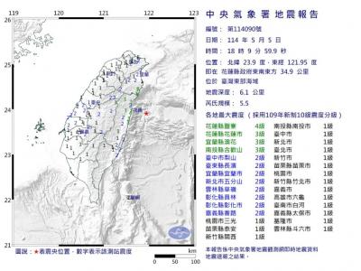
A magnitude 5.9 earthquake that struck about 33km off the coast of Hualien City was the "main shock" in a series of quakes in the area, with aftershocks expected over the next three days, the Central Weather Administration (CWA) said yesterday. Prior to the magnitude 5.9 quake shaking most of Taiwan at 6:53pm yesterday, six other earthquakes stronger than a magnitude of 4, starting with a magnitude 5.5 quake at 6:09pm, occurred in the area. CWA Seismological Center Director Wu Chien-fu (吳健富) confirmed that the quakes were all part of the same series and that the magnitude 5.5 temblor was

The brilliant blue waters, thick foliage and bucolic atmosphere on this seemingly idyllic archipelago deep in the Pacific Ocean belie the key role it now plays in a titanic geopolitical struggle. Palau is again on the front line as China, and the US and its allies prepare their forces in an intensifying contest for control over the Asia-Pacific region. The democratic nation of just 17,000 people hosts US-controlled airstrips and soon-to-be-completed radar installations that the US military describes as “critical” to monitoring vast swathes of water and airspace. It is also a key piece of the second island chain, a string of

The Central Weather Administration has issued a heat alert for southeastern Taiwan, warning of temperatures as high as 36°C today, while alerting some coastal areas of strong winds later in the day. Kaohsiung’s Neimen District (內門) and Pingtung County’s Neipu Township (內埔) are under an orange heat alert, which warns of temperatures as high as 36°C for three consecutive days, the CWA said, citing southwest winds. The heat would also extend to Tainan’s Nansi (楠西) and Yujing (玉井) districts, as well as Pingtung’s Gaoshu (高樹), Yanpu (鹽埔) and Majia (瑪家) townships, it said, forecasting highs of up to 36°C in those areas