China intends to launch eight maritime surveillance satellites over the next eight years, a senior official from the National Satellite Ocean Application Service has announced, amid efforts by China to improve its surveillance capabilities in the contested waters of the East and South China Sea.
Jiang Xingwei (蔣興偉), director of the service, said four of the satellites would be used to monitor sea coloration and two to keep track of sea currents which would bring China up to speed with other developed countries on oceanographic surveillance.
Of special interest to other countries involved in territorial disputes with China over islets and waters in the area, including Taiwan and Japan, the other two orbiters are to act as maritime radar satellites to reinforce China’s jurisdiction over those areas.
China currently relies on aircraft and three orbiters to conduct surveillance of its territorial waters and islands — including the Diaoyutai Islands (釣魚台) and Scarborough Shoal (黃岩島, Huangyan Island) — but those do no have the ability to lock on fixed locations, Jiang said, adding that the two new maritime radar satellites would remedy that shortcoming.
Two Hai Yang-1 (HY-1) and one HY-2 oceanography satellites were launched in 2002, 2007 and last year respectively. However, their sun-synchronous orbit means that the satellites are to pass over the same location every two to three days.
Jiang said the additions would also bolster China’s remote-sensing capabilities over waters near other contested islands, including the Paracels (Xisha Islands, 西沙群島) and Spratlys (Nansha Islands, 南沙群島) in the South China Sea by augmenting overall surveillance.
The National Development and Reform Commission has already approved the program, Xinhua news agency reported Jiang as saying yesterday. It is not known whether the new satellites are to be from the HY family or from a different type. According to NASA, China plans to launch HY-2B, HY-2C and HY-2D this year, in 2015 and in 2019.
According to an official from the State Oceanic Administration, since its launch three years ago, the China Oceanic Information Network has expanded its coverage from offshore waters to distant areas and now covers about 300,000km2 of ocean.
Satellite imagery and data are used by the China Marine Surveillance to monitor the “legitimate” and “illegal” use of China’s territorial waters and areas within its exclusive economic zone, as well as to provide maritime services with key information on oil spills and emergencies.

The brilliant blue waters, thick foliage and bucolic atmosphere on this seemingly idyllic archipelago deep in the Pacific Ocean belie the key role it now plays in a titanic geopolitical struggle. Palau is again on the front line as China, and the US and its allies prepare their forces in an intensifying contest for control over the Asia-Pacific region. The democratic nation of just 17,000 people hosts US-controlled airstrips and soon-to-be-completed radar installations that the US military describes as “critical” to monitoring vast swathes of water and airspace. It is also a key piece of the second island chain, a string of
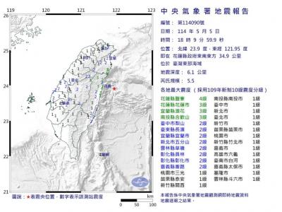
A magnitude 5.9 earthquake that struck about 33km off the coast of Hualien City was the "main shock" in a series of quakes in the area, with aftershocks expected over the next three days, the Central Weather Administration (CWA) said yesterday. Prior to the magnitude 5.9 quake shaking most of Taiwan at 6:53pm yesterday, six other earthquakes stronger than a magnitude of 4, starting with a magnitude 5.5 quake at 6:09pm, occurred in the area. CWA Seismological Center Director Wu Chien-fu (吳健富) confirmed that the quakes were all part of the same series and that the magnitude 5.5 temblor was

The Central Weather Administration has issued a heat alert for southeastern Taiwan, warning of temperatures as high as 36°C today, while alerting some coastal areas of strong winds later in the day. Kaohsiung’s Neimen District (內門) and Pingtung County’s Neipu Township (內埔) are under an orange heat alert, which warns of temperatures as high as 36°C for three consecutive days, the CWA said, citing southwest winds. The heat would also extend to Tainan’s Nansi (楠西) and Yujing (玉井) districts, as well as Pingtung’s Gaoshu (高樹), Yanpu (鹽埔) and Majia (瑪家) townships, it said, forecasting highs of up to 36°C in those areas

Taiwan will now have four additional national holidays after the Legislative Yuan passed an amendment today, which also made Labor Day a national holiday for all sectors. The Chinese Nationalist Party (KMT) and Taiwan People’s Party (TPP) used their majority in the Legislative Yuan to pass the amendment to the Act on Implementing Memorial Days and State Holidays (紀念日及節日實施辦法), which the parties jointly proposed, in its third and final reading today. The legislature passed the bill to amend the act, which is currently enforced administratively, raising it to the legal level. The new legislation recognizes Confucius’ birthday on Sept. 28, the