To celebrate the fifth anniversary of the launch of FORMOSAT-2, the National Space Organization (NSPO) will host a series of educational events on the operations and functions of the satellite, the NSPO said yesterday.
FORMOSAT-2, the first remote sensing satellite developed by the NSPO, was launched into orbit 891km above sea level on May 21, 2004. It is the first satellite to be solely controlled by the government.
To mark its fifth year, the NSPO will host an array of events to exhibit the satellite’s successes such as hosting workshops for target groups to learn about FORMOSAT-2, NSPO director-general Miau Jiun-jih (苗君易) said.
The first event from tomorrow to May 15 will be a satellite-photo identification contest, he said.
BICEP
“For example, did you know that from a birds-eye view, the Hualien plain looks like an extended bicep? Every week on the NSPO Web site, we will post two satellite pictures of a place on the island. Those who identify the place correctly can enter a raffle prize draw,” he said.
One of the satellite’s missions is to captures images of the island as well as other locations on the Earth, Miau said, adding that the data could be used in fields such as natural resource research, climate observation, disaster prevention and environmental protection.
“The biggest difference between FORMOSAT-2 and other satellites is that it has the function of recording images of the same terrestrial or oceanic landscape everyday, so it can be used to monitor potential disasters or record landscape evolution,” he said.
EXCLUSIVE PROCESSING
With its exclusive Image Processing System developed by the NSPO, images taken by the satellite can be processed according to the end-user’s needs, he said, adding that the Central Weather Bureau used the data regularly.
Besides the image-capturing function, the satellite can also provide data for global positioning systems, Miau said.
In March last year, the FORMOSAT-2 conducted a high-resolution photo surveillance of the collapsing Wilkins Ice Shelf in Antarctica on the request of NASA which issued calls for countries to focus any available high-resolution satellites on the shelf.
The photos that were taken by FORMOSAT-2 were the most detailed observation ever of an ice shelf disintegration. Commenting on the mission, National Cheng Kung University Department of Earth Sciences associate professor Liu Cheng-chie (劉正千) said it was the first time that such a high-resolution satellite had been deployed to monitor the Antarctic.
ADDITIONAL REPORTING BY STAFF WRITER

An essay competition jointly organized by a local writing society and a publisher affiliated with the Chinese Communist Party (CCP) might have contravened the Act Governing Relations Between the People of the Taiwan Area and the Mainland Area (臺灣地區與大陸地區人民關係條例), the Mainland Affairs Council (MAC) said on Thursday. “In this case, the partner organization is clearly an agency under the CCP’s Fujian Provincial Committee,” MAC Deputy Minister and spokesperson Liang Wen-chieh (梁文傑) said at a news briefing in Taipei. “It also involves bringing Taiwanese students to China with all-expenses-paid arrangements to attend award ceremonies and camps,” Liang said. Those two “characteristics” are typically sufficient
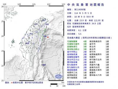
A magnitude 5.9 earthquake that struck about 33km off the coast of Hualien City was the "main shock" in a series of quakes in the area, with aftershocks expected over the next three days, the Central Weather Administration (CWA) said yesterday. Prior to the magnitude 5.9 quake shaking most of Taiwan at 6:53pm yesterday, six other earthquakes stronger than a magnitude of 4, starting with a magnitude 5.5 quake at 6:09pm, occurred in the area. CWA Seismological Center Director Wu Chien-fu (吳健富) confirmed that the quakes were all part of the same series and that the magnitude 5.5 temblor was

The brilliant blue waters, thick foliage and bucolic atmosphere on this seemingly idyllic archipelago deep in the Pacific Ocean belie the key role it now plays in a titanic geopolitical struggle. Palau is again on the front line as China, and the US and its allies prepare their forces in an intensifying contest for control over the Asia-Pacific region. The democratic nation of just 17,000 people hosts US-controlled airstrips and soon-to-be-completed radar installations that the US military describes as “critical” to monitoring vast swathes of water and airspace. It is also a key piece of the second island chain, a string of

The Central Weather Administration has issued a heat alert for southeastern Taiwan, warning of temperatures as high as 36°C today, while alerting some coastal areas of strong winds later in the day. Kaohsiung’s Neimen District (內門) and Pingtung County’s Neipu Township (內埔) are under an orange heat alert, which warns of temperatures as high as 36°C for three consecutive days, the CWA said, citing southwest winds. The heat would also extend to Tainan’s Nansi (楠西) and Yujing (玉井) districts, as well as Pingtung’s Gaoshu (高樹), Yanpu (鹽埔) and Majia (瑪家) townships, it said, forecasting highs of up to 36°C in those areas