Taiwan-produced quality satellite imagery has been in great demand by countries affected by the earthquake-generated tsunami, because Taiwan's second satellite, officially known as ROCSAT-2, is the only satellite able to take pictures of disaster areas every day, the National Space Program Office (NSPO) said yesterday.
The satellite, nicknamed FORMOSAT-2, can produce images of objects as small as 2m across, and orbits the planet 14 times a day, passing over areas affected by the tsunami twice a day. Since Dec. 28, the satellite has been conducting a special operation to take pictures of the most-seriously affected areas in South Asia.
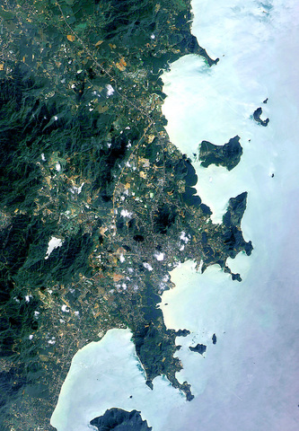
PHOTO: AP/NSPO
"The satellite is the only one that can visit the area daily. Thus, we can conduct observations more frequently than others," Lance Wu (
Although other satellite images, such as those produced by IKONOS, have better resolution -- about 1m -- the satellites that produce them only pass the affected areas once every two or three days, Wu said.
"So far, images from the disaster area covering about 100,000km2 have been taken. The mission will continue for several weeks, in order to build a useful database for future geographic and ecological analysis," Wu said.
According to Wu, several seriously affected areas, such as Banda Aceh, Phuket, the Andaman Islands and the Maldives had been imaged consecutively. The images have been available free-of-charge on the NSPO Web site, and more than 60 countries have downloaded what they needed.
"Several affected countries, such as Thailand and Indonesia, even requested us to take pictures of specific coastal areas, where landform and terrain features had been changed, for the sake of disaster relief," Wu said.
It is evident that satellite technology has been fundamental in the recovery effort in the post-tsunami period. For disaster relief workers, satellite images now serve as a basic reference to find ways to reach some disaster areas in which roads and buildings had been destroyed by the tsunami, NSPO officials said.
According to Wu An-ming (
Over the last two weeks, the satellite mostly took pictures of Indonesia, Thailand, the Maldives and adjacent areas.
In the following two weeks, the satellite will focus mostly on the west side of South Asia, such as India and Sri Lanka.
"Taiwan will soon produce a valuable database, which will contain images of the disaster area covering more than 200,000km2 as a whole. It will definitely benefit researchers in related fields for future analysis by comparing images," Wu An-ming said.
Taiwanese researchers can now perform analysis on geographic changes by reading images taken by the satellite without going to the affected areas in person.

An essay competition jointly organized by a local writing society and a publisher affiliated with the Chinese Communist Party (CCP) might have contravened the Act Governing Relations Between the People of the Taiwan Area and the Mainland Area (臺灣地區與大陸地區人民關係條例), the Mainland Affairs Council (MAC) said on Thursday. “In this case, the partner organization is clearly an agency under the CCP’s Fujian Provincial Committee,” MAC Deputy Minister and spokesperson Liang Wen-chieh (梁文傑) said at a news briefing in Taipei. “It also involves bringing Taiwanese students to China with all-expenses-paid arrangements to attend award ceremonies and camps,” Liang said. Those two “characteristics” are typically sufficient
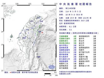
A magnitude 5.9 earthquake that struck about 33km off the coast of Hualien City was the "main shock" in a series of quakes in the area, with aftershocks expected over the next three days, the Central Weather Administration (CWA) said yesterday. Prior to the magnitude 5.9 quake shaking most of Taiwan at 6:53pm yesterday, six other earthquakes stronger than a magnitude of 4, starting with a magnitude 5.5 quake at 6:09pm, occurred in the area. CWA Seismological Center Director Wu Chien-fu (吳健富) confirmed that the quakes were all part of the same series and that the magnitude 5.5 temblor was

The brilliant blue waters, thick foliage and bucolic atmosphere on this seemingly idyllic archipelago deep in the Pacific Ocean belie the key role it now plays in a titanic geopolitical struggle. Palau is again on the front line as China, and the US and its allies prepare their forces in an intensifying contest for control over the Asia-Pacific region. The democratic nation of just 17,000 people hosts US-controlled airstrips and soon-to-be-completed radar installations that the US military describes as “critical” to monitoring vast swathes of water and airspace. It is also a key piece of the second island chain, a string of
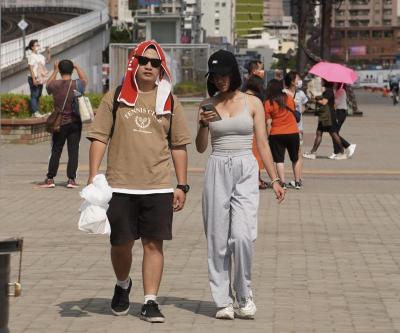
The Central Weather Administration has issued a heat alert for southeastern Taiwan, warning of temperatures as high as 36°C today, while alerting some coastal areas of strong winds later in the day. Kaohsiung’s Neimen District (內門) and Pingtung County’s Neipu Township (內埔) are under an orange heat alert, which warns of temperatures as high as 36°C for three consecutive days, the CWA said, citing southwest winds. The heat would also extend to Tainan’s Nansi (楠西) and Yujing (玉井) districts, as well as Pingtung’s Gaoshu (高樹), Yanpu (鹽埔) and Majia (瑪家) townships, it said, forecasting highs of up to 36°C in those areas