A giant bushfire on the edge of Sydney, which has blanketed the city in smoke causing a spike in respiratory illnesses and the cancelation of outdoor sports, will take weeks to control, but will not be extinguished without heavy rain, firefighters said yesterday.
Thousands of weary firefighters, who have been battling bushfires for a month, were fighting nearly 100 blazes in New South Wales.
The mega-fire north of Sydney, Australia’s largest city, was created on Friday when several fires merged and was burning across 335,000 hectares.
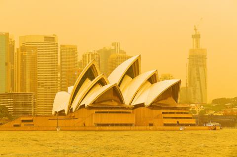
Photo: EPA-EFE
The pilot of a helicopter supporting the fire efforts was lucky to escape with just minor injuries after crashing about 200km north of the city yesterday.
A shipping container full of fireworks exploded as the fire raged, authorities said.
There were no immediate reports of injuries from the explosion.
“We need flooding rain to put these fires out. That’s really what is going to stop it,” the New South Wales Rural Fire Service said. “These will take many weeks to put out.”
Bushfires are common in Australia during the summer, which begins in December, but this year the fires started much earlier, blamed on soaring temperatures, dry winds and arson.
A three-year drought has left much of Australia tinder dry.
The fires around Sydney have been pumping such vast amounts of smoke into the air that they appear as significant rain on the radars, the Australian Bureau of Meteorology said on Twitter.
New South Wales Health on Friday said that about 1,140 people had sought medical assistance for breathing issues or asthma in the past week — a quarter more than in a typical week.
New South Wales Ambulance fielded about one-third more calls.
Six people have been killed, nearly 700 houses burned down and millions of hectares of land razed.
Strong winds fanned flames toward several suburbs in southwest Sydney yesterday.
“It’s been going on all day, a fire came from the back and we put it out, but then another one came from the side so the firies [firefighters] covered the house in foam,” said Luke Wright, who helped save his brother’s home.
“The fence has been damaged, but that’s about it, very lucky,” Wright told local media.
Rural Fire Service Commissioner Shane Fitzsimmons said that the worst might still be ahead, with temperatures forecast to rise to 40°C in the next few days and no meaningful rainfall expected until late next month.
“It’s a tough couple of months ahead yet and we’ve already seen the horrific consequences of fire so far this season,” Fitzsimmons told Australia’s 9News.
Easing conditions overnight provided brief respite in the state and allowed for controlled burning to prevent damage during the anticipated heat wave.
Queensland was yesterday battling about 45 bushfires in temperatures as high as 40°C.
Additional reporting by AFP

Taiwan Semiconductor Manufacturing Co (TSMC, 台積電), the world’s largest foundry service provider, yesterday said that global semiconductor revenue is projected to hit US$1.5 trillion in 2030, after the figure exceeds US$1 trillion this year, as artificial intelligence (AI) demand boosts consumption of token and compute power. “We are still at the beginning of the AI revolution, but we already see a significant impact across the whole semiconductor ecosystem,” TSMC deputy cochief operating officer Kevin Zhang (張曉強) said at the company’s annual technology symposium in Hsinchu City. “It is fair to say that in the past decade, smartphones and other mobile devices were
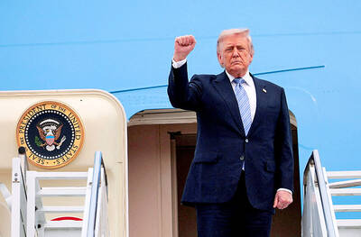
US-CHINA SUMMIT: MOFA welcomed US reassurance of no change in its Taiwan policy; Trump said he did not comment when Xi talked of opposing independence US President Donald Trump yesterday said he has not made a decision on whether to move forward with a major arms package for Taiwan after hearing concerns about it from Chinese President Xi Jinping (習近平). Trump’s comments on Taiwan came as he flew back to Washington after wrapping up critical talks in which both leaders said important progress was made in stabilizing US-China relations even as deep differences persist between the world’s two biggest powers on Iran and Taiwan. “I will make a determination,” Trump said, adding: “I’ll be making decisions. But, you know, I think the last thing we need right

TAIWAN ISSUE: US treasury secretary Scott Bessent said on the first day of meetings that ‘it wouldn’t be a US-China summit without the Taiwan issue coming up’ There were no surprises on the first day of the summit between US President Donald Trump and Chinese President Xi Jinping (習近平), the Mainland Affairs Council (MAC) said yesterday, as the government reiterated that cross-strait stability is crucial to the Asia-Pacific region, as well as the world. As the two presidents met for a highly anticipated summit yesterday, Chinese state media reported that Xi warned Trump that missteps regarding Taiwan could push their two countries into “conflict.” Trump arrived in China with accolades for his host, calling Xi a “great leader” and “friend,” and extending an invitation to visit the White House
SECURITY: Taipei presses the US for arms supplies, saying the arms sales are not only a reflection of the US security commitment to Taiwan but also serve as a mutual deterrent against regional threats Taiwan is committed to preserving the cross-strait “status quo” and contributing to regional peace and stability, the Presidential Office said yesterday. “It is an undeniable fact that the Republic of China is a sovereign and independent democratic nation,” Presidential Office spokeswoman Karen Kuo (郭雅慧) reiterated, adding that Beijing has no right to claim sovereignty over Taiwan. The statements came after US President Donald Trump warned against Taiwanese independence. Trump wrapped up a state visit to Beijing on Friday, during which Chinese President Xi Jinping (習近平) had pressed him not to support Taiwan. Taiwan depends heavily on US security backing to deter China from carrying