Researchers at National Taiwan University’s Institute of Oceanography yesterday shared unprecedented data about super typhoons collected from two buoys deployed in the Pacific Ocean, adding that they would work with the Philippines to install similar buoys next year.
Then-institute director Wei Ching-ling (魏慶琳) in 2015 led a team to deploy the two buoys in waters off the nation’s southeast coast.
Engineer Chang Hung-i (張宏毅) developed key circuit boards on the US-made buoys for receiving maritime and weather data, while the buoys also carried Taiwanese devices for measuring temperature, ocean current, salinity, dissolved oxygen and chlorophyll levels of sea water, Wei told a news conference at the Ministry of Science and Technology in Taipei.
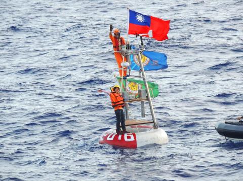
Photo courtesy of National Taiwan University’s Institute of Oceanography
The two areas are often in the trajectory of typhoons heading to Taiwan, institute associate professor Yang Yiing-jang (楊穎堅) said, adding that the buoys have resisted nine typhoons, including four super typhoons, thanks to their solid anchoring 5.5km below the surface.
Built at a cost of NT$10 million (US$323,572 at the current exchange rate) each, the buoys gathered unprecedented data of a super typhoon in 2016 when Typhoon Nepartak passed above them, Yang said, adding that the buoys were about 20km from the center of the eye of the typhoon.
In the four hours after Nepartak arrived in the area, the temperature of the water dropped by 1.5°C, data showed.
The typhoon only absorbed a little heat from upper sea levels, but it caused rapid stirring among different layers of the area, which scooped cold water from lower levels that cooled down the sea surface, thus restricting the typhoon’s growth, Yang said.
The data and images of the typhoons taken by the buoys’ instruments are conducive for advance weather forecasts, as scientists had been curious about a typhoon’s effects on sea temperature and they had no high-resolution images of typhoons at sea previously, Yang said.
The team detailed its findings in a paper titled “The role of enhanced velocity shears in rapid ocean cooling during Super Typhoon Nepartak 2016,” which was published in the journal Nature Communications on April 9, with Yang listed as the lead author.
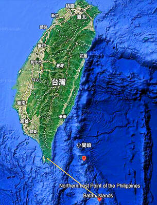
The team has received a request for collaboration from the Philippines and plans to deploy a similar buoy in the waters off the east coast of the Philippines next year, Yang said.
Yang also expressed the hope that Taiwan would be able to join the UN’s World Meteorological Organization to share its oceanic and weather research results.

‘FORM OF PROTEST’: The German Institute Taipei said it was ‘shocked’ to see Nazi symbolism used in connection with political aims as it condemned the incident Sung Chien-liang (宋建樑), who led efforts to recall Democratic Progressive Party (DPP) Legislator Lee Kun-cheng (李坤城), was released on bail of NT$80,000 yesterday amid an outcry over a Nazi armband he wore to questioning the night before. Sung arrived at the New Taipei City District Prosecutors’ Office for questioning in a recall petition forgery case on Tuesday night wearing a red armband bearing a swastika, carrying a copy of Adolf Hitler’s Mein Kampf and giving a Nazi salute. Sung left the building at 1:15am without the armband and apparently covering the book with a coat. This is a serious international scandal and Chinese
A US Marine Corps regiment equipped with Naval Strike Missiles (NSM) is set to participate in the upcoming Balikatan 25 exercise in the Luzon Strait, marking the system’s first-ever deployment in the Philippines. US and Philippine officials have separately confirmed that the Navy Marine Expeditionary Ship Interdiction System (NMESIS) — the mobile launch platform for the Naval Strike Missile — would take part in the joint exercise. The missiles are being deployed to “a strategic first island chain chokepoint” in the waters between Taiwan proper and the Philippines, US-based Naval News reported. “The Luzon Strait and Bashi Channel represent a critical access
COUNTERINTELLIGENCE TRAINING: The ministry said 87.5 percent of the apprehended Chinese agents were reported by service members they tried to lure into becoming spies Taiwanese organized crime, illegal money lenders, temples and civic groups are complicit in Beijing’s infiltration of the armed forces, the Ministry of National Defense (MND) said in a report yesterday. Retired service members who had been turned to Beijing’s cause mainly relied on those channels to infiltrate the Taiwanese military, according to the report to be submitted to lawmakers ahead of tomorrow’s hearing on Chinese espionage in the military. Chinese intelligence typically used blackmail, Internet-based communications, bribery or debts to loan sharks to leverage active service personnel to do its bidding, it said. China’s main goals are to collect intelligence, and develop a
PERSONAL DATA: The implicated KMT members allegedly compiled their petitions by copying names from party lists without the consent of the people concerned Judicial authorities searched six locations yesterday and questioned six people, including one elderly Chinese Nationalist Party (KMT) member and five KMT Youth League associates, about alleged signature forgery and fraud relating to their recall efforts against two Democratic Progressive Party (DPP) legislators. After launching a probe into alleged signature forgery and related fraud in the KMT’s recall effort, prosecutors received a number of complaints, including about one petition that had 1,748 signatures of voters whose family members said they had already passed away, and also voters who said they did not approve the use of their name, Taipei Deputy Chief Prosecutor