The government has completed preparations to minimize the possible effects of heavy rain, President Tsai Ing-wen (蔡英文) said yesterday evening after the Central Weather Bureau (CWB) issued a warning of heavy to extremely heavy rain for Keelung, Taipei, New Taipei City, Kaohsiung and Yilan, Hualien, Taitung and Pingtung counties.
In a Facebook post, Tsai said the government has activated disaster prevention and mitigation plans, with rubber dinghies, pumps and other flood-relief equipment ready to be deployed on short notice, and 4,000 soldiers at the ready.
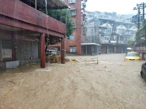
Heavy rain yesterday morning caused flooding in several districts of Keelung, after torrential rain pounded northern Taiwan on Saturday afternoon and early evening, causing flooding in several areas of the city as well as Taipei and New Taipei City.

Photo: Lu Hsien-hsiu, Taipei Times
A section of Fusing Road in Keelung’s Jhongshan District (中山) was flooded with water up to the knee height, leaving many vehicles partially submerged in the water and creating a small waterfall of muddy water in one alley.
Inspecting the flooded areas, Keelung Mayor Lin Yu-chang (林右昌) said the drainpipes along Sinsi Street are not up to standard and culverts in the city might be too old and damaged.
The city would dig up the pipes to investigate, he said.

Photo: Yu Chao-fu, Taipei Times
Taipei Mayor Ko Wen-je (柯文哲) yesterday said the city government would inspect the drainage systems and make any needed improvements after the Taipei Fire Department received 161 reports of flooded roads and 20 reports of flooded residences as of 7:30pm on Saturday.
Amid widespread flooding in southern Taiwan last month, Ko had voiced confidence in the city’s ability to handle major rainfall.
“As long as the hourly accumulated rainfall is less than 78 millimeters, the majority of areas in Taipei will not flood,” he said on Aug. 26.
However, Saturday’s rain led to flooding in several areas where the rainfall did not reach 78mm.
Asked about criticism of the city’s flood control management, Ko yesterday said “some areas will still flood, but the water recedes very quickly… Taipei will still flood if the hourly accumulated rainfall exceeds 78 millimeters, but even though it exceeded 100 millimeters in some areas last night, the flooding situation was still bearable.”
He said he visited the emergency disaster response center on Saturday evening and the Taipei Department of Environmental Protection was scheduled to check the drainage systems at those areas yesterday.
“We always write review reports after every incident, so we can improve bit by bit every time,” he said. “We will especially mark out the areas that flooded even though the hourly accumulated rainfall did not reach 78 millimeters.”
The Taipei Public Works Department’s Hydraulic Engineering Office said the hourly accumulated rainfall on Saturday exceeded 78.8mm at 31 weather stations in more than half the city’s administrative districts.
All 70 sewage pumping stations were operating when rain began, while 186 more water pumps were deployed after 6pm, it said.
The hourly accumulated rainfall recorded in the Gongguan area (公館) reached 104mm and 100mm in Daan Forest Park (大安森林公園), with flooding reported on Keelung Road near Gongguan at about 5:50pm, but the water receded by 6:50pm, the department said.
The weather bureau on Saturday afternoon had issued a heavy rain or torrential rain alert for 17 counties and cities nationwide and a thunderstorm alert for Taipei, New Taipei City and Keelung.
The bureau defines extremely heavy rain as accumulated rainfall of 200mm or more within 24 hours; torrential rain refers to accumulated rainfall of 350mm or more; and extremely torrential rain means accumulated rainfall of 500mm or more.
In related news, Tropical Storm Mangkhut was yesterday afternoon upgraded to a typhoon.
As of 2pm yesterday it was about 3,000km from the east coast of Taiwan, moving westward.
It is expected to intensify with the possibility that it could reach Taiwan on Saturday, the bureau forecast.
Additional reporting by Tai Chih-sheng

SECURITY: As China is ‘reshaping’ Hong Kong’s population, Taiwan must raise the eligibility threshold for applications from Hong Kongers, Chiu Chui-cheng said When Hong Kong and Macau citizens apply for residency in Taiwan, it would be under a new category that includes a “national security observation period,” Mainland Affairs Council (MAC) Minister Chiu Chui-cheng (邱垂正) said yesterday. President William Lai (賴清德) on March 13 announced 17 strategies to counter China’s aggression toward Taiwan, including incorporating national security considerations into the review process for residency applications from Hong Kong and Macau citizens. The situation in Hong Kong is constantly changing, Chiu said to media yesterday on the sidelines of the Taipei Technology Run hosted by the Taipei Neihu Technology Park Development Association. With

CARROT AND STICK: While unrelenting in its military threats, China attracted nearly 40,000 Taiwanese to over 400 business events last year Nearly 40,000 Taiwanese last year joined industry events in China, such as conferences and trade fairs, supported by the Chinese government, a study showed yesterday, as Beijing ramps up a charm offensive toward Taipei alongside military pressure. China has long taken a carrot-and-stick approach to Taiwan, threatening it with the prospect of military action while reaching out to those it believes are amenable to Beijing’s point of view. Taiwanese security officials are wary of what they see as Beijing’s influence campaigns to sway public opinion after Taipei and Beijing gradually resumed travel links halted by the COVID-19 pandemic, but the scale of

A US Marine Corps regiment equipped with Naval Strike Missiles (NSM) is set to participate in the upcoming Balikatan 25 exercise in the Luzon Strait, marking the system’s first-ever deployment in the Philippines. US and Philippine officials have separately confirmed that the Navy Marine Expeditionary Ship Interdiction System (NMESIS) — the mobile launch platform for the Naval Strike Missile — would take part in the joint exercise. The missiles are being deployed to “a strategic first island chain chokepoint” in the waters between Taiwan proper and the Philippines, US-based Naval News reported. “The Luzon Strait and Bashi Channel represent a critical access

Pope Francis is be laid to rest on Saturday after lying in state for three days in St Peter’s Basilica, where the faithful are expected to flock to pay their respects to history’s first Latin American pontiff. The cardinals met yesterday in the Vatican’s synod hall to chart the next steps before a conclave begins to choose Francis’ successor, as condolences poured in from around the world. According to current norms, the conclave must begin between May 5 and 10. The cardinals set the funeral for Saturday at 10am in St Peter’s Square, to be celebrated by the dean of the College