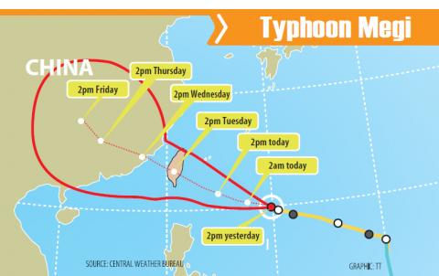
The Central Weather Bureau was scheduled to issue a sea alert for Typhoon Megi as of press time last night, as the storm gained power on its way toward eastern and southern Taiwan.
By 8pm yesterday, the center of the typhoon was 920km east-southeast of Taiwan proper, moving west-northwest at 16kph, packing winds up to 137kph.
The radius of the storm was 200km, the bureau said.

The sea alert was scheduled to issued at 11:30pm last night. Because of the approaching typhoon, the Maritime and Port Bureau said that several shipping route services would be canceled today, tomorrow and Wednesday.
A majority of the canceled shipping services are in eastern and southern Taiwan, including those between Taitung’s Fugang Fishing Port and Green Island (綠島); between Houbi Lake (後壁湖) in Pingtung County’s Hengchun Peninsula (恆春半島) and Orchid Island (Lanyu, 蘭嶼); and between Donggang (東港) in Pintung County and Siaoliouciou Island (小琉球).
Other canceled services are between Keelung and Matsu, Kaohsiung and Penghu, Taipei and Pingtan in China’s Fujian Province and Matsu’s Nangan (南竿) and Dongyin (東引島) islets.
Based on the bureau’s projected path, Megi is likely to make landfall in the nation’s southeast.
It is predicted to move across the nation and continue toward China, according to the bureau’s analysis.
To better understand the typhoon’s structure, the bureau said it will today activate the Dropsonde Observation for Typhoon Surveillance near the Taiwan Region project.
The jet used in the project is to climb to an altitude of about 13km and conduct observations in key spots along the path of the typhoon’s movement, the bureau said, adding that the data would be transmitted back to the bureau via satellite.
The bureau said the information collected through the project can reduce the margin of error in its 72-hour forecast for the typhoon’s path by about 6.5 percent.
Megi is a rare example of predictions provided by different weather forecast agencies around the world being consistent with one another, bureau Director-General Cheng Ming-dean (鄭明典) said on Facebook.
Other agencies have made only minor adjustments to their predictions of how the typhoon would move over the next few days, he wrote.
Former bureau director-general Daniel Wu (吳德榮) said it is still too early to say the exact location where the typhoon would make landfall.
Wu said the interaction between the typhoon and Taiwan’s terrain would also skew the typhoon’s path before its eye makes landfall, making its movement difficult to predict.

‘TAIWAN-FRIENDLY’: The last time the Web site fact sheet removed the lines on the US not supporting Taiwanese independence was during the Biden administration in 2022 The US Department of State has removed a statement on its Web site that it does not support Taiwanese independence, among changes that the Taiwanese government praised yesterday as supporting Taiwan. The Taiwan-US relations fact sheet, produced by the department’s Bureau of East Asian and Pacific Affairs, previously stated that the US opposes “any unilateral changes to the status quo from either side; we do not support Taiwan independence; and we expect cross-strait differences to be resolved by peaceful means.” In the updated version published on Thursday, the line stating that the US does not support Taiwanese independence had been removed. The updated

‘CORRECT IDENTIFICATION’: Beginning in May, Taiwanese married to Japanese can register their home country as Taiwan in their spouse’s family record, ‘Nikkei Asia’ said The government yesterday thanked Japan for revising rules that would allow Taiwanese nationals married to Japanese citizens to list their home country as “Taiwan” in the official family record database. At present, Taiwanese have to select “China.” Minister of Foreign Affairs Lin Chia-lung (林佳龍) said the new rule, set to be implemented in May, would now “correctly” identify Taiwanese in Japan and help protect their rights, the Ministry of Foreign Affairs said in a statement. The statement was released after Nikkei Asia reported the new policy earlier yesterday. The name and nationality of a non-Japanese person marrying a Japanese national is added to the

AT RISK: The council reiterated that people should seriously consider the necessity of visiting China, after Beijing passed 22 guidelines to punish ‘die-hard’ separatists The Mainland Affairs Council (MAC) has since Jan. 1 last year received 65 petitions regarding Taiwanese who were interrogated or detained in China, MAC Minister Chiu Chui-cheng (邱垂正) said yesterday. Fifty-two either went missing or had their personal freedoms restricted, with some put in criminal detention, while 13 were interrogated and temporarily detained, he said in a radio interview. On June 21 last year, China announced 22 guidelines to punish “die-hard Taiwanese independence separatists,” allowing Chinese courts to try people in absentia. The guidelines are uncivilized and inhumane, allowing Beijing to seize assets and issue the death penalty, with no regard for potential

‘UNITED FRONT’ FRONTS: Barring contact with Huaqiao and Jinan universities is needed to stop China targeting Taiwanese students, the education minister said Taiwan has blacklisted two Chinese universities from conducting academic exchange programs in the nation after reports that the institutes are arms of Beijing’s United Front Work Department, Minister of Education Cheng Ying-yao (鄭英耀) said in an exclusive interview with the Chinese-language Liberty Times (the Taipei Times’ sister paper) published yesterday. China’s Huaqiao University in Xiamen and Quanzhou, as well as Jinan University in Guangzhou, which have 600 and 1,500 Taiwanese on their rolls respectively, are under direct control of the Chinese government’s political warfare branch, Cheng said, citing reports by national security officials. A comprehensive ban on Taiwanese institutions collaborating or