FORMOSAT-2, the nation’s first locally developed ionospheric research and surface mapping satellite, has been decommissioned after 12 years in operation.
The satellite had remained operational eight years past its expected lifespan of five years, but a series of equipment failures finally forced the National Space Organization (NSPO) to pull the plug.
One of its four reaction wheels, which rotate and position the satellite, malfunctioned in 2013, and another one stopped working in June, which meant FORMOSAT-2 could no longer take pictures or make observations, the agency said.
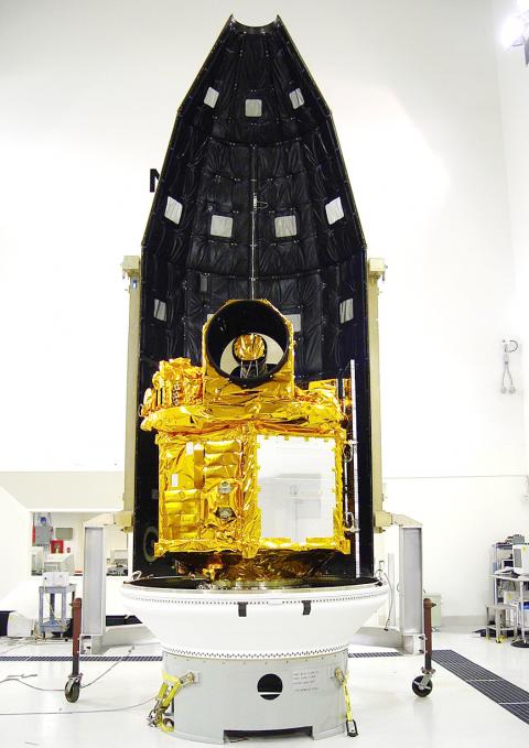
Photo courtesy of the National Space Organization
After weeks of repair efforts, the NSPO determined that the problematic wheels could not be fixed and that FORMOSAT-2 had to be retired.
The agency made its last contact with FORMOSAT-2 during a decommissioning ceremony on Friday at its headquarters in Hsinchu, bringing an end to the nation’s most successful surveillance satellite program.
“With gratitude, we congratulate FORMOSAT-2 for the service it provided. It accompanied us over the past 12 years as we grew up. It is like an old friend, or more like a teacher,” NSPO Director Chang Guey-shin (張桂祥) said. “The satellite made an unparalleled contribution to the nation’s space development.”
The satellite, which cost NT$4.6 billion (US$145.5 million at current exchange rates) to build, was launched on May 21, 2004, from Vandenberg Air Force Base in California.
It circles the Earth once every 103 minutes and passes over Taiwan twice a day.
It was the nation’s only satellite with a daily revisit capability, meaning it could take pictures of a given location every day, and the only one that could photograph the polar regions.
The satellite took about 2.55 million pictures of the Earth’s surface.
The pictures brought in about NT$600 million in revenue, while images worth about NT$1.1 billion were provided to 191 government agencies and 176 academic institutions in Taiwan free of charge.
The satellite helped with scientific research, environmental monitoring, urban planning and natural disaster prevention and evaluation.
FORMOSAT-2 was used in 343 disaster response missions, providing authorities with immediate images of damaged areas during the Indian Ocean earthquake and tsunami in December 2004, Hurricane Katrina in the US in 2005, the Sichuan earthquake in China in 2008, Typhoon Morakot in Taiwan in 2009 and the Tohoku earthquake and tsunami in Japan in 2011.
For eight days after Morakot hit Taiwan, the satellite took detailed pictures of all areas damaged by the typhoon to help the government evaluate the situation and plan its emergency response.
FORMOSAT-2 was also the first satellite to observe the transient luminous event — an electrical-discharge phenomena well above the altitudes of normal lightning and storm clouds — and its observations have been cited in numerous academic research.
Additional reporting by staff writer

AIR SUPPORT: The Ministry of National Defense thanked the US for the delivery, adding that it was an indicator of the White House’s commitment to the Taiwan Relations Act Deputy Minister of National Defense Po Horng-huei (柏鴻輝) and Representative to the US Alexander Yui on Friday attended a delivery ceremony for the first of Taiwan’s long-awaited 66 F-16C/D Block 70 jets at a Lockheed Martin Corp factory in Greenville, South Carolina. “We are so proud to be the global home of the F-16 and to support Taiwan’s air defense capabilities,” US Representative William Timmons wrote on X, alongside a photograph of Taiwanese and US officials at the event. The F-16C/D Block 70 jets Taiwan ordered have the same capabilities as aircraft that had been upgraded to F-16Vs. The batch of Lockheed Martin

GRIDLOCK: The National Fire Agency’s Special Search and Rescue team is on standby to travel to the countries to help out with the rescue effort A powerful earthquake rocked Myanmar and neighboring Thailand yesterday, killing at least three people in Bangkok and burying dozens when a high-rise building under construction collapsed. Footage shared on social media from Myanmar’s second-largest city showed widespread destruction, raising fears that many were trapped under the rubble or killed. The magnitude 7.7 earthquake, with an epicenter near Mandalay in Myanmar, struck at midday and was followed by a strong magnitude 6.4 aftershock. The extent of death, injury and destruction — especially in Myanmar, which is embroiled in a civil war and where information is tightly controlled at the best of times —
China's military today said it began joint army, navy and rocket force exercises around Taiwan to "serve as a stern warning and powerful deterrent against Taiwanese independence," calling President William Lai (賴清德) a "parasite." The exercises come after Lai called Beijing a "foreign hostile force" last month. More than 10 Chinese military ships approached close to Taiwan's 24 nautical mile (44.4km) contiguous zone this morning and Taiwan sent its own warships to respond, two senior Taiwanese officials said. Taiwan has not yet detected any live fire by the Chinese military so far, one of the officials said. The drills took place after US Secretary

THUGGISH BEHAVIOR: Encouraging people to report independence supporters is another intimidation tactic that threatens cross-strait peace, the state department said China setting up an online system for reporting “Taiwanese independence” advocates is an “irresponsible and reprehensible” act, a US government spokesperson said on Friday. “China’s call for private individuals to report on alleged ‘persecution or suppression’ by supposed ‘Taiwan independence henchmen and accomplices’ is irresponsible and reprehensible,” an unnamed US Department of State spokesperson told the Central News Agency in an e-mail. The move is part of Beijing’s “intimidation campaign” against Taiwan and its supporters, and is “threatening free speech around the world, destabilizing the Indo-Pacific region, and deliberately eroding the cross-strait status quo,” the spokesperson said. The Chinese Communist Party’s “threats