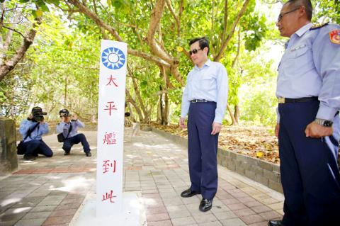
President Ma Ying-jeou (馬英九), ignoring US criticism, yesterday visited Itu Aba Island (Taiping Island, 太平島) in the South China Sea, where he reiterated the Republic of China’s (ROC) sovereignty over the land mass and its status as an island.
Accompanied by government officials and academics, Ma boarded the presidential plane at the Songshan Air Force Base in Taipei, flying to Pingtung County early yesterday morning, before transferring to a C-130 transport aircraft bound for Itu Aba.
Ma arrived at about 11am on Itu Aba, the largest island in the Spratly Islands (Nansha Islands, 南沙群島), which has been administered by Taiwan since 1956 and is also claimed by China, the Philippines and Vietnam.

Photo: CNA
Ma is the second ROC president to set foot on the island, after then-president Chen Shui-bian (陳水扁), who visited it on Feb. 2, 2008.
After meeting with staff stationed on the island, Ma delivered a speech in front of a memorial tablet bearing a message from him that read: “Peace in the South China Sea and our national territory secure forever.”
“I am very happy to be here today, before the Lunar New Year, on Taiping Island, with all of you stationed on the Nansha Islands, which are part of the southern territories of the ROC,” Ma said.
Ma said the disputed islands in the South China Sea were first discovered, named and used by the Chinese in the 1st century BC, and the ROC government later published maps of the islands in 1935 and 1947.
The Spratly Islands, the Paracel Islands (Xisha Islands, 西沙群島), the Macclesfield Bank (Zhongsha Islands, 中沙群島), and Pratas Islands (Dongsha Islands, 東沙群島) are all an inherent part of the ROC’s territory and waters, whether from the perspective of history, geography, or international law, Ma said.
“To resolve disputes in the South China Sea... on May 26, 2015, I put forth the South China Sea Peace Initiative, calling on all parties concerned to reduce tensions, increase dialogue, abide by international law, uphold freedom of navigation and overflight, maintain peace and stability in the South China Sea, and settle disputes peacefully,” Ma said.
In an effort to flesh out the initiative, Ma yesterday proposed a “South China Sea Peace Initiative Roadmap,” based on “three yeses and three noes”: yes to cooperation, no to confrontation; yes to sharing, no to monopolization; and yes to pragmatism, no to intransigence.
Ma said the roadmap offers a viable path, two essential elaborations and three phases of progress.
“The viable path consists of shelving disputes, integrated planning and zonal development,” he said.
The two essential elaborations call for concerned parties to be included in the initiative’s consultation mechanism, and to engage in cooperation and negotiations, Ma said, adding that the mechanism should not impede the formation of a final agreement on the territorial disputes.
The three phases of progress refer to short, medium and long-term planning, with the government working to transform Taiping into an island for peace and rescue operations, as well as an ecologically friendly and low-carbon island, the president said.
Ma rejected the Philippines’ categorization of Itu Aba as a “rock,” saying the island has sufficient natural vegetation thanks to its favorable soil and water quality.
“Such statements [by the Philippines] have no basis in either science or fact; they are totally wrong. The economic, environmental and cultural realms all provide sufficient evidence to show that the island has — and has had for more than 100 years — ample resources to be self-sufficient,” Ma said.
The island is home to 106 indigenous plant species, several animal species, a variety of sources of food, and a 10-bed hospital manned by two physicians, a dentist and three nurses, he said.
“All this evidence fully demonstrates that Taiping Island can sustain human habitation and an economic life of its own. It is not a rock, but an island, and meets the criteria for an island as specified in Article 121 of the UN Convention on the Law of the Sea,” he added.
Ma arrived back in Taipei at about 5:40pm.

TRAGEDY STRIKES TAIPEI: The suspect died after falling off a building after he threw smoke grenades into Taipei Main Station and went on a killing spree in Zhongshan A 27-year-old suspect allegedly threw smoke grenades in Taipei Main Station and then proceeded to Zhongshan MRT Station in a random killing spree that resulted in the death of the suspect and two other civilians, and seven injured, including one in critical condition, as of press time last night. The suspect, identified as a man surnamed Chang Wen (張文), allegedly began the attack at Taipei Main Station, the Taipei Fire Department said, adding that it received a report at 5:24pm that smoke grenades had been thrown in the station. One man in his 50s was rushed to hospital after a cardiac arrest

SAFETY FIRST: Double the number of police were deployed at the Taipei Marathon, while other cities released plans to bolster public event safety Authorities across Taiwan have stepped up security measures ahead of Christmas and New Year events, following a knife and smoke bomb attack in Taipei on Friday that left four people dead and 11 injured. In a bid to prevent potential copycat incidents, police deployments have been expanded for large gatherings, transport hubs, and other crowded public spaces, according to official statements from police and city authorities. Taipei Mayor Chiang Wan-an (蔣萬安) said the city has “comprehensively raised security readiness” in crowded areas, increased police deployments with armed officers, and intensified patrols during weekends and nighttime hours. For large-scale events, security checkpoints and explosives

A car bomb killed a senior Russian general in southern Moscow yesterday morning, the latest high-profile army figure to be blown up in a blast that came just hours after Russian and Ukrainian delegates held separate talks in Miami on a plan to end the war. Kyiv has not commented on the incident, but Russian investigators said they were probing whether the blast was “linked” to “Ukrainian special forces.” The attack was similar to other assassinations of generals and pro-war figures that have either been claimed, or are widely believed to have been orchestrated, by Ukraine. Russian Lieutenant General Fanil Sarvarov, 56, head

PUBLIC SAFETY: The premier said that security would be tightened in transport hubs, while President Lai commended the public for their bravery The government is to deploy more police, including rapid response units, in crowded public areas to ensure a swift response to any threats, President William Lai (賴清德) said yesterday after a knife attack killed three people and injured 11 in Taipei the previous day. Lai made the remarks following a briefing by the National Police Agency on the progress of the investigation, saying that the attack underscored the importance of cooperation in public security between the central and local governments. The attack unfolded in the early evening on Friday around Taipei Main Station’s M7 exit and later near the Taipei MRT’s Zhongshan