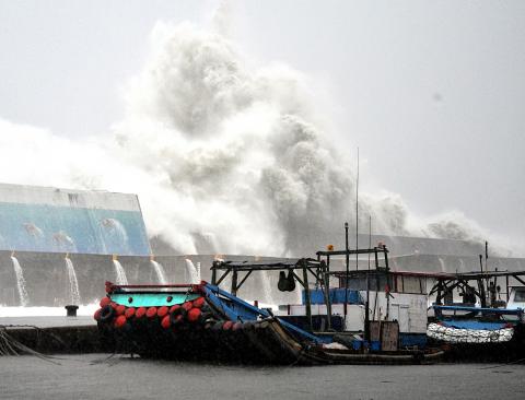
Typhoon Usagi came closest to Taiwan yesterday afternoon and is moving away from the nation in the direction of Hong Kong, but heavy rainfall is still expected to continue throughout today, the Central Weather Bureau said yesterday.
As of 7:15pm, Typhoon Usagi had weakened slightly, with its center 140km southwest of Oluanpi (鵝鑾鼻). The wind speed near its center was 48 meters per second in a radius of 280km and the typhoon was moving west-northwest at 19kph.
The bureau said that the land alert for Usagi may possibly be lifted as soon as this morning. The center of the typhoon is estimated to be about 510km west of Oluanpi by 5pm today.

Photo: CNA
However, the bureau warned that severe torrential rains may still hit areas including eastern Taiwan, Pintung County, Greater Kaohsiung and Nantou County, and torrential rains may fall in areas including northern Taiwan, Greater Taichung and Greater Tainan today.
People living in mountainous areas should especially watch out for landslides, falling rocks, mud flows or flash floods; and people living in low-lying areas should be prepared for flooding, it said.
It also warned that people should avoid heading to the ocean because waves and wind along the coastline are still very strong, and that strong wind gusts at level 10 on the Beaufort scale — 88kph to 103kph — are also likely to blow in the greater Taipei area.

Photo: Wang Hsiu-ting, Taipei Times
Seawater encroachment occurred at Jiupeng Village (九棚) in Pingtung County’s Manchou Township (滿州) yesterday morning, leading to the evacuation of about 20 households in the village.
As of 6:21pm yesterday, the Central Emergency Operation Center said a total of 3,075 people from 36 townships in seven counties have been evacuated from their homes, with 1,043 people settled at temporary shelters, due to the strong winds and heavy rainfall brought by Typhoon Usagi.
In addition, the center said six people have been injured in the typhoon, 45,618 households experienced power outages and 5,210 households were without running water.
The Water Resources Agency said according to the Central Weather Bureau’s 24-hour rainfall forecast for between 8am yesterday and 8am today, the average rainfall would be between 150mm and 300mm in Yilan and Pintung counties, 200mm to 400mm in Hualien and Taitung counties, and 300mm to 500mm on the Hengchun Peninsula (恆春半島) in Pingtung County, so people living in low-lying areas should take precautionary measures against flooding.
A total of 712 water pumps have already been distributed in various areas, while another 65 pumps are ready to be deployed depending on actual flooding situations, the agency said.
It added that it plans to release water at 10 major reservoirs across the nation according to the rainfall, so the public should not engage in water activities in downstream areas close to reservoirs.

NO WORK, CLASS: President William Lai urged people in the eastern, southern and northern parts of the country to be on alert, with Typhoon Kong-rey approaching Typhoon Kong-rey is expected to make landfall on Taiwan’s east coast today, with work and classes canceled nationwide. Packing gusts of nearly 300kph, the storm yesterday intensified into a typhoon and was expected to gain even more strength before hitting Taitung County, the US Navy’s Joint Typhoon Warning Center said. The storm is forecast to cross Taiwan’s south, enter the Taiwan Strait and head toward China, the Central Weather Administration (CWA) said. The CWA labeled the storm a “strong typhoon,” the most powerful on its scale. Up to 1.2m of rainfall was expected in mountainous areas of eastern Taiwan and destructive winds are likely

KONG-REY: A woman was killed in a vehicle hit by a tree, while 205 people were injured as the storm moved across the nation and entered the Taiwan Strait Typhoon Kong-rey slammed into Taiwan yesterday as one of the biggest storms to hit the nation in decades, whipping up 10m waves, triggering floods and claiming at least one life. Kong-rey made landfall in Taitung County’s Chenggong Township (成功) at 1:40pm, the Central Weather Administration (CWA) said. The typhoon — the first in Taiwan’s history to make landfall after mid-October — was moving north-northwest at 21kph when it hit land, CWA data showed. The fast-moving storm was packing maximum sustained winds of 184kph, with gusts of up to 227kph, CWA data showed. It was the same strength as Typhoon Gaemi, which was the most

Air and rail traffic around Taiwan were disrupted today while power cuts occurred across the country as Typhoon Kong-rey, predicted to make landfall in eastern Taiwan this afternoon, continued edging closer to the country. A total of 241 passenger and cargo flights departing from or arriving at Taiwan Taoyuan International Airport were canceled today due to the typhoon, Taoyuan International Airport Corp said. As of 9:30am, 109 inbound flights, 103 outbound flights and 29 cargo flights had been canceled, the company said. Taiwan Railway Corp also canceled all express trains on its Western Trunk Line, Eastern Trunk Line, South-Link Line and attached branches

Typhoon Kong-rey is forecast to make landfall in eastern Taiwan this afternoon and would move out to sea sometime overnight, the Central Weather Administration (CWA) said. As of 9am today, Kong-rey's outer rim was covering most of Taiwan except for the north. The storm's center was 110km east of Oluanpi (鵝鑾鼻), Taiwan's southernmost tip, and moving northwest at 28kph. It was carrying maximum sustained winds near its center of 184kph, and gusts of up to 227kph, the CWA said. At a news conference this morning, CWA forecaster Chu Mei-lin (朱美霖) said Kong-rey is moving "extremely fast," and is expected to make landfall between