South Korean President Lee Myung-bak ordered an investigation yesterday into how a navy ship sank near the disputed North Korea border, but officials said it was unlikely to have been the result of an attack by Pyongyang.
Initial speculation that North Korea might have sunk the ship spooked Wall Street, where share prices dipped overnight partly on geopolitical concerns, and the won dropped against the dollar.
“Every possibility should be considered in investigating the causes of the ship sinking and the investigation must be fast and thorough,” Lee’s office quoted him as telling an emergency government meeting early yesterday.
A reporter on Baengnyeongdo island, near where the ship sank, said about 10 navy and coastguard vessels, along with divers, were searching the area and the wreckage.
MBC television quoted defense ministry sources as saying it was unlikely the prickly North was involved, although they were checking for a possible link. The ministry was also investigating whether it was the result of an internal explosion.
Presidential Blue House spokeswoman Kim Eun-hye also said there had been no unusual movements by North Korea, which has a million-strong military, much of it near the heavily armed border that has divided the Korean peninsula for more than 50 years.
Local media quoted a presidential official as saying satellite pictures and other information showed no sign of the North Korean military in the area at the time of the sinking.
The defense ministry said 58 of the 104 on board had been rescued and Yonhap quoted navy officials as saying several had died. It was later quoted as saying 46 crew were still missing.

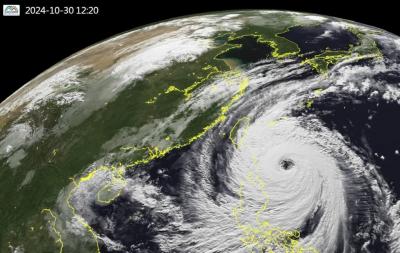
Super Typhoon Kong-rey is the largest cyclone to impact Taiwan in 27 years, the Central Weather Administration (CWA) said today. Kong-rey’s radius of maximum wind (RMW) — the distance between the center of a cyclone and its band of strongest winds — has expanded to 320km, CWA forecaster Chang Chun-yao (張竣堯) said. The last time a typhoon of comparable strength with an RMW larger than 300km made landfall in Taiwan was Typhoon Herb in 1996, he said. Herb made landfall between Keelung and Suao (蘇澳) in Yilan County with an RMW of 350km, Chang said. The weather station in Alishan (阿里山) recorded 1.09m of

STORM’S PATH: Kong-Rey could be the first typhoon to make landfall in Taiwan in November since Gilda in 1967. Taitung-Green Island ferry services have been halted Tropical Storm Kong-rey is forecast to strengthen into a typhoon early today and could make landfall in Taitung County between late Thursday and early Friday, the Central Weather Administration (CWA) said yesterday. As of 2pm yesterday, Kong-Rey was 1,030km east-southeast of Oluanpi (鵝鑾鼻), the nation’s southernmost point, and was moving west at 7kph. The tropical storm was packing maximum sustained winds of 101kph, with gusts of up to 126 kph, CWA data showed. After landing in Taitung, the eye of the storm is forecast to move into the Taiwan Strait through central Taiwan on Friday morning, the agency said. With the storm moving

NO WORK, CLASS: President William Lai urged people in the eastern, southern and northern parts of the country to be on alert, with Typhoon Kong-rey approaching Typhoon Kong-rey is expected to make landfall on Taiwan’s east coast today, with work and classes canceled nationwide. Packing gusts of nearly 300kph, the storm yesterday intensified into a typhoon and was expected to gain even more strength before hitting Taitung County, the US Navy’s Joint Typhoon Warning Center said. The storm is forecast to cross Taiwan’s south, enter the Taiwan Strait and head toward China, the Central Weather Administration (CWA) said. The CWA labeled the storm a “strong typhoon,” the most powerful on its scale. Up to 1.2m of rainfall was expected in mountainous areas of eastern Taiwan and destructive winds are likely

The Central Weather Administration (CWA) yesterday at 5:30pm issued a sea warning for Typhoon Kong-rey as the storm drew closer to the east coast. As of 8pm yesterday, the storm was 670km southeast of Oluanpi (鵝鑾鼻) and traveling northwest at 12kph to 16kph. It was packing maximum sustained winds of 162kph and gusts of up to 198kph, the CWA said. A land warning might be issued this morning for the storm, which is expected to have the strongest impact on Taiwan from tonight to early Friday morning, the agency said. Orchid Island (Lanyu, 蘭嶼) and Green Island (綠島) canceled classes and work