An airplane slid off an icy runway and powerful winds and heavy snow forced hundreds of flight cancellations across Europe on Saturday as blasts of freezing cold buffeted the region.
An Air Berlin plane slid off the runway in Nuremberg, Germany, and was stuck in the snow late on Friday. Nobody was injured, but the airport was closed for more than two hours.
More than 300 car accidents were reported on icy streets in the southwestern state of Baden-Wuerttemberg, with more than 40 people injured. The western state of North Rhine-Westphalia reported 108 accidents.

PHOTO: REUTERS
At the German-French border near Freiburg, hundreds of trucks were stuck for hours when French authorities closed the highway because of heavy snow. The Red Cross handed out blankets and hot soup to the drivers.
By early afternoon, 226 domestic and international flights had been canceled at Frankfurt airport as a low pressure system from the Mediterranean brought gusty winds and several centimeters of snow. Crews struggled to clear the runways and the few planes that managed to take off had to be de-iced first, Frankfurt airport duty manager Heinz Fass said.
In the UK, cold winds swept in from the north, sending temperatures tumbling to minus 14ºC in parts of Scotland and northern England. The country is in the midst of its longest cold snap in three decades and transport has been disrupted in many areas.
The arctic weather — unusual by the UK’s temperate standards — led to record demand for gas. In a Web cast on Saturday, British Prime Minister Gordon Brown reassured Britons that gas supplies were not running out, even though almost 100 businesses had been asked to stop using gas to conserve supplies. Supplies of salt and sand for gritting dangerously icy roads were also running low.
Heavy snow forced the cancellation of all flights at Dublin Airport in Ireland. Traffic at London’s Heathrow Airport, Europe’s busiest, was also affected, with British Airways alone canceling about 50 flights.
Schoenefeld and Tegel, the main airports in Berlin, as well as Munich airport, also reported cancellations.
In France, dozens of flights were canceled in Toulouse, Lyon and Brest. Heavy snow snapped power lines in the southeast, near the Mediterranean, leaving at least 7,500 homes without power. And at least 12 French Cup soccer matches had to be rescheduled because of the cold, the French football federation said.

SECURITY: As China is ‘reshaping’ Hong Kong’s population, Taiwan must raise the eligibility threshold for applications from Hong Kongers, Chiu Chui-cheng said When Hong Kong and Macau citizens apply for residency in Taiwan, it would be under a new category that includes a “national security observation period,” Mainland Affairs Council (MAC) Minister Chiu Chui-cheng (邱垂正) said yesterday. President William Lai (賴清德) on March 13 announced 17 strategies to counter China’s aggression toward Taiwan, including incorporating national security considerations into the review process for residency applications from Hong Kong and Macau citizens. The situation in Hong Kong is constantly changing, Chiu said to media yesterday on the sidelines of the Taipei Technology Run hosted by the Taipei Neihu Technology Park Development Association. With

CARROT AND STICK: While unrelenting in its military threats, China attracted nearly 40,000 Taiwanese to over 400 business events last year Nearly 40,000 Taiwanese last year joined industry events in China, such as conferences and trade fairs, supported by the Chinese government, a study showed yesterday, as Beijing ramps up a charm offensive toward Taipei alongside military pressure. China has long taken a carrot-and-stick approach to Taiwan, threatening it with the prospect of military action while reaching out to those it believes are amenable to Beijing’s point of view. Taiwanese security officials are wary of what they see as Beijing’s influence campaigns to sway public opinion after Taipei and Beijing gradually resumed travel links halted by the COVID-19 pandemic, but the scale of

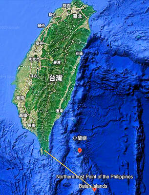
A US Marine Corps regiment equipped with Naval Strike Missiles (NSM) is set to participate in the upcoming Balikatan 25 exercise in the Luzon Strait, marking the system’s first-ever deployment in the Philippines. US and Philippine officials have separately confirmed that the Navy Marine Expeditionary Ship Interdiction System (NMESIS) — the mobile launch platform for the Naval Strike Missile — would take part in the joint exercise. The missiles are being deployed to “a strategic first island chain chokepoint” in the waters between Taiwan proper and the Philippines, US-based Naval News reported. “The Luzon Strait and Bashi Channel represent a critical access

Pope Francis is be laid to rest on Saturday after lying in state for three days in St Peter’s Basilica, where the faithful are expected to flock to pay their respects to history’s first Latin American pontiff. The cardinals met yesterday in the Vatican’s synod hall to chart the next steps before a conclave begins to choose Francis’ successor, as condolences poured in from around the world. According to current norms, the conclave must begin between May 5 and 10. The cardinals set the funeral for Saturday at 10am in St Peter’s Square, to be celebrated by the dean of the College