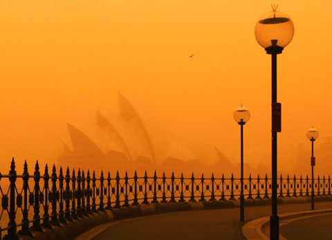
The worst dust storm in decades swept across eastern Australia yesterday, blanketing Sydney and snarling transport as freak conditions also brought earthquakes, giant hailstones and even a tornado.
Gale-force winds dumped thousands of tonnes of red desert dust on Australia’s biggest city, shrouding it in an eerie orange haze and coating the iconic Sydney Opera House in a fine layer of powder.
The storm, reportedly the most serious since the 1940s, then spread 600km up the coast to Queensland and could even hit New Zealand, some 4,000km away, experts said.

PHOTO: REUTERS
Dust covered most of New South Wales, Australia’s most populous state, pushing air pollution to record levels and depositing about 75,000 tonnes of powder in the Tasman Sea every hour.
“Dust storms like this occur quite regularly but they rarely travel this far east and come through Sydney,” said John Leys, principal research scientist with New South Wales’ Department of Climate Change and Water.
Sydney residents wore masks and covered their mouths with scarves as they traveled to work under hazy skies. Traffic was bumper-to-bumper on major highways.
Air transport was severely disrupted with passengers facing long delays at Sydney airport and many international flights diverted to Melbourne and Brisbane.
Flag-carrier Qantas urged passengers to cancel any non-urgent travel, while budget offshoot Jetstar offered free flight rescheduling and refunds.
“We encourage any passengers with non-essential travel arrangements to reconsider their travel plans for the day,” Qantas said in a statement.
Sydney Ferries suspended harbor services and police warned drivers to take extra care in poor visibility. Ambulance workers reported a sudden spike in respiratory problems.
“We have already seen an increase in calls to people suffering from asthma and other respiratory problems,” New South Wales Ambulance Service said in a statement.
Australia, in the grip of a decade-long drought, is emerging from an abnormally hot southern hemisphere winter including the hottest August on record.
Elsewhere in New South Wales, hail stones “the size of cricket balls” smashed windows as thunderstorms and gale-force winds lashed the state late on Tuesday.
“We’ve had reports of cars with both their front and rear windscreens smashed,” an official from the State Emergency Service said.
Victoria state was on alert for flash floods as heavy rains fell, following a pair of minor earthquakes on Tuesday. The 3.0 and 2.6-magnitude tremors did not cause any damage, officials said.
Residents near the capital Canberra described how a mini-tornado tore through the town of Murrumbateman late on Tuesday.
“It sounded like a jumbo jet rumbling onto the roof,” one resident told ABC.
Police in southwestern New South Wales, bordering Victoria, reported bizarre conditions on Tuesday as dark red skies thick with dust cut visibility to just 2m to 3m in some areas.
“I’ve never seen anything like it in all my life, and I grew up here,” a police officer at the town of Broken Hill told national news agency AAP.
“It was darker than night-time and lasted for about half an hour. You couldn’t even see the street lights,” he said.
And residents near the capital Canberra described how a mini-tornado tore through the town of Murrumbateman late on Tuesday.
“It sounded like a jumbo jet rumbling on to the roof,” one resident told ABC.

The CIA has a message for Chinese government officials worried about their place in Chinese President Xi Jinping’s (習近平) government: Come work with us. The agency released two Mandarin-language videos on social media on Thursday inviting disgruntled officials to contact the CIA. The recruitment videos posted on YouTube and X racked up more than 5 million views combined in their first day. The outreach comes as CIA Director John Ratcliffe has vowed to boost the agency’s use of intelligence from human sources and its focus on China, which has recently targeted US officials with its own espionage operations. The videos are “aimed at

STEADFAST FRIEND: The bills encourage increased Taiwan-US engagement and address China’s distortion of UN Resolution 2758 to isolate Taiwan internationally The Presidential Office yesterday thanked the US House of Representatives for unanimously passing two Taiwan-related bills highlighting its solid support for Taiwan’s democracy and global participation, and for deepening bilateral relations. One of the bills, the Taiwan Assurance Implementation Act, requires the US Department of State to periodically review its guidelines for engagement with Taiwan, and report to the US Congress on the guidelines and plans to lift self-imposed limitations on US-Taiwan engagement. The other bill is the Taiwan International Solidarity Act, which clarifies that UN Resolution 2758 does not address the issue of the representation of Taiwan or its people in

US Indo-Pacific Commander Admiral Samuel Paparo on Friday expressed concern over the rate at which China is diversifying its military exercises, the Financial Times (FT) reported on Saturday. “The rates of change on the depth and breadth of their exercises is the one non-linear effect that I’ve seen in the last year that wakes me up at night or keeps me up at night,” Paparo was quoted by FT as saying while attending the annual Sedona Forum at the McCain Institute in Arizona. Paparo also expressed concern over the speed with which China was expanding its military. While the US

SHIFT: Taiwan’s better-than-expected first-quarter GDP and signs of weakness in the US have driven global capital back to emerging markets, the central bank head said The central bank yesterday blamed market speculation for the steep rise in the local currency, and urged exporters and financial institutions to stay calm and stop panic sell-offs to avoid hurting their own profitability. The nation’s top monetary policymaker said that it would step in, if necessary, to maintain order and stability in the foreign exchange market. The remarks came as the NT dollar yesterday closed up NT$0.919 to NT$30.145 against the US dollar in Taipei trading, after rising as high as NT$29.59 in intraday trading. The local currency has surged 5.85 percent against the greenback over the past two sessions, central