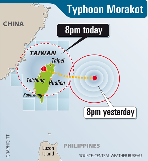
The Central Weather Bureau (CWB) issued a land warning yesterday morning for Typhoon Morakot, and warned residents in the north and northeast that the storm was packing powerful winds and torrential rain.
At press time, all local governments had declared a typhoon day for today except the Kinmen and Lienchiang county governments, which said work and classes will continue as usual.
At 9:15pm, the center of the typhoon was located 350km off the coast of Ilan. It was moving northwesterly at 20kph, packing winds up to 144kph and had a radius of 250km.

PHOTO: WALLY SANTANA, AP
If Morakot maintains its course and continues to gain strength, the system would cover Taiwan proper in its entirety early today, meteorologists said.
Residents in mountainous areas in northern and eastern Taiwan should be alert for landslides and people should stay away from the coastline, the bureau said.
Morakot has the potential to become a stronger typhoon, said Chen Yi-liang (陳怡良), division chief at the bureau’s forecast center.

The approach of Morakot brought heavy rain to northern regions yesterday, including Taipei County and Hsinchu County.
More than 130mm of rain fell in mountainous areas in these counties, the bureau said, adding that more rain was expected as the typhoon moved closer to the east coast.
Domestic airlines canceled around 20 flights to outlying islands yesterday, while some shipping firms canceled services to Makung (馬公), Matsu, Liouciou (琉球) and Green Island (綠島).
Travelers were advised to check with their airlines about possible flight schedule changes today.
All 18 forest recreational areas will be closed today, including Hohuanshan (合歡山), Taipingshan (太平山), Aowanda (奧萬大) and Kenting (墾丁).
Freeway toll stations in any area that has declared a typhoon day will stop collecting tolls starting at 12am for 24 hours.
Meanwhile, the Central Personnel Administration (CPA) said yesterday it would take legal action against the creators of a fake CPA Web site that announced the suspension of work and classes today several hours before the official announcement was made shortly after 4pm.
The fake Web site had been up for at least three hours by then, claiming that local governments in north, east and central Taiwan had declared today a Typhoon Day at 1:12pm.
The CPA said it reported the incident to the police. It reminded the public that the decision to declare a typhoon day was up to local governments, not the CPA.
In related news, the Council of Agriculture said that 377.46 tonnes of emergency stocks of rice and vegetables have been distributed to 18 cities and counties to meet possible food shortages.
The public should not panic about potential shortages because the nation’s second harvest was recently collected.
ADDITIONAL REPORTING BY SHIH HSIU-CHUAN, MEGGIE LU AND AGENCIES

ENDEAVOR MANTA: The ship is programmed to automatically return to its designated home port and would self-destruct if seized by another party The Endeavor Manta, Taiwan’s first military-specification uncrewed surface vehicle (USV) tailor-made to operate in the Taiwan Strait in a bid to bolster the nation’s asymmetric combat capabilities made its first appearance at Kaohsiung’s Singda Harbor yesterday. Taking inspiration from Ukraine’s navy, which is using USVs to force Russia’s Black Sea fleet to take shelter within its own ports, CSBC Taiwan (台灣國際造船) established a research and development unit on USVs last year, CSBC chairman Huang Cheng-hung (黃正弘) said. With the exception of the satellite guidance system and the outboard motors — which were purchased from foreign companies that were not affiliated with Chinese-funded

PERMIT REVOKED: The influencer at a news conference said the National Immigration Agency was infringing on human rights and persecuting Chinese spouses Chinese influencer “Yaya in Taiwan” (亞亞在台灣) yesterday evening voluntarily left Taiwan, despite saying yesterday morning that she had “no intention” of leaving after her residence permit was revoked over her comments on Taiwan being “unified” with China by military force. The Ministry of the Interior yesterday had said that it could forcibly deport the influencer at midnight, but was considering taking a more flexible approach and beginning procedures this morning. The influencer, whose given name is Liu Zhenya (劉振亞), departed on a 8:45pm flight from Taipei International Airport (Songshan airport) to Fuzhou, China. Liu held a news conference at the airport at 7pm,

AIR SUPPORT: The Ministry of National Defense thanked the US for the delivery, adding that it was an indicator of the White House’s commitment to the Taiwan Relations Act Deputy Minister of National Defense Po Horng-huei (柏鴻輝) and Representative to the US Alexander Yui on Friday attended a delivery ceremony for the first of Taiwan’s long-awaited 66 F-16C/D Block 70 jets at a Lockheed Martin Corp factory in Greenville, South Carolina. “We are so proud to be the global home of the F-16 and to support Taiwan’s air defense capabilities,” US Representative William Timmons wrote on X, alongside a photograph of Taiwanese and US officials at the event. The F-16C/D Block 70 jets Taiwan ordered have the same capabilities as aircraft that had been upgraded to F-16Vs. The batch of Lockheed Martin

GRIDLOCK: The National Fire Agency’s Special Search and Rescue team is on standby to travel to the countries to help out with the rescue effort A powerful earthquake rocked Myanmar and neighboring Thailand yesterday, killing at least three people in Bangkok and burying dozens when a high-rise building under construction collapsed. Footage shared on social media from Myanmar’s second-largest city showed widespread destruction, raising fears that many were trapped under the rubble or killed. The magnitude 7.7 earthquake, with an epicenter near Mandalay in Myanmar, struck at midday and was followed by a strong magnitude 6.4 aftershock. The extent of death, injury and destruction — especially in Myanmar, which is embroiled in a civil war and where information is tightly controlled at the best of times —