Malaysian Prime Minister Abdullah Ahmad Badawi took the oath of office for a new five-year term yesterday, rejecting calls to resign after unprecedented electoral setbacks wiped out the ruling coalition's two-thirds majority and shook the political landscape and the stock market.
Abdullah was sworn in at a simple, nationally broadcast ceremony in front of the constitutional monarch, King Mizan Zainal Abidin, and dozens of dignitaries in the national palace's glittering throne room.
"I pledge to carry out my duties honestly and with all my abilities," Abdullah said, reading out the oath. "I pledge to protect and uphold the Constitution."
He smiled occasionally and mingled with guests after the ceremony, belying the stress of the last two days when he was confronted with the biggest political crisis of his life.
His National Front ruling coalition secured a fresh mandate in Saturday's general elections, but lost its two-thirds parliamentary majority and relinquished control of five of the 13 states to opposition parties.
The opposition alliance now has 82 seats in the 222 member parliament, a massive jump from its 19 seats in the outgoing house.
Abdullah got a much-needed vote of support from his United Malays National Organization to stay on as both party president and prime minister at a special meeting of the party yesterday, despite calls from former prime minister Mahathir Mohamad to quit.
But he has an enormous task ahead in holding together his battered coalition and filling holes in his Cabinet -- four ministers lost seats in the weekend election, including Works Minister S. Samy Vellu, the head of the main Indian party in the coalition.
A key partner, the Malaysian Chinese Association, dismissed speculation that it might pull out of the coalition.
Sources close to Abdullah said he had canceled plans to attend next week's Organization of the Islamic Conference summit in Senegal -- he was to hand over chairmanship of the 57-member grouping -- to deal with the crisis at home.
"A two-party system seems likely to evolve from the outcome of this general election," wrote Wong Chun Wai, the editor of the pro-government Star daily, in his newspaper yesterday.
Also see: Asia stocks fall on reports of dip in US employment

ENDEAVOR MANTA: The ship is programmed to automatically return to its designated home port and would self-destruct if seized by another party The Endeavor Manta, Taiwan’s first military-specification uncrewed surface vehicle (USV) tailor-made to operate in the Taiwan Strait in a bid to bolster the nation’s asymmetric combat capabilities made its first appearance at Kaohsiung’s Singda Harbor yesterday. Taking inspiration from Ukraine’s navy, which is using USVs to force Russia’s Black Sea fleet to take shelter within its own ports, CSBC Taiwan (台灣國際造船) established a research and development unit on USVs last year, CSBC chairman Huang Cheng-hung (黃正弘) said. With the exception of the satellite guidance system and the outboard motors — which were purchased from foreign companies that were not affiliated with Chinese-funded

PERMIT REVOKED: The influencer at a news conference said the National Immigration Agency was infringing on human rights and persecuting Chinese spouses Chinese influencer “Yaya in Taiwan” (亞亞在台灣) yesterday evening voluntarily left Taiwan, despite saying yesterday morning that she had “no intention” of leaving after her residence permit was revoked over her comments on Taiwan being “unified” with China by military force. The Ministry of the Interior yesterday had said that it could forcibly deport the influencer at midnight, but was considering taking a more flexible approach and beginning procedures this morning. The influencer, whose given name is Liu Zhenya (劉振亞), departed on a 8:45pm flight from Taipei International Airport (Songshan airport) to Fuzhou, China. Liu held a news conference at the airport at 7pm,

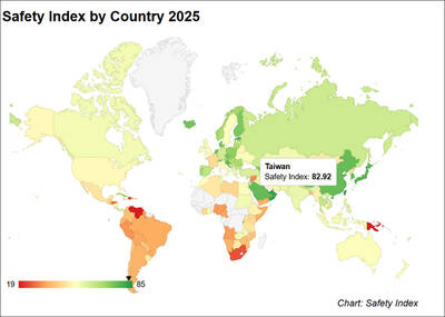
Taiwan was ranked the fourth-safest country in the world with a score of 82.9, trailing only Andorra, the United Arab Emirates and Qatar in Numbeo’s Safety Index by Country report. Taiwan’s score improved by 0.1 points compared with last year’s mid-year report, which had Taiwan fourth with a score of 82.8. However, both scores were lower than in last year’s first review, when Taiwan scored 83.3, and are a long way from when Taiwan was named the second-safest country in the world in 2021, scoring 84.8. Taiwan ranked higher than Singapore in ninth with a score of 77.4 and Japan in 10th with

GRIDLOCK: The National Fire Agency’s Special Search and Rescue team is on standby to travel to the countries to help out with the rescue effort A powerful earthquake rocked Myanmar and neighboring Thailand yesterday, killing at least three people in Bangkok and burying dozens when a high-rise building under construction collapsed. Footage shared on social media from Myanmar’s second-largest city showed widespread destruction, raising fears that many were trapped under the rubble or killed. The magnitude 7.7 earthquake, with an epicenter near Mandalay in Myanmar, struck at midday and was followed by a strong magnitude 6.4 aftershock. The extent of death, injury and destruction — especially in Myanmar, which is embroiled in a civil war and where information is tightly controlled at the best of times —