US Defense Secretary Donald Rumsfeld acknowledged Thursday that more US troops may have to be sent to Iraq to provide security for January elections that are threatened by a wave of insurgent violence.
Rumsfeld said he believed elections could still be held in January but he sketched out a scenario in which they might not be held in parts of the country where the violence is too great.
"Let's say you tried to have an election and you could have it in three-quarters or four-fifths of the country, but some places you couldn't, because the violence was too great," he said.
"Well, so be it," he told the Senate Armed Services Committee. "You have an election that's not quite perfect. Is it better than not having an election? You bet."
General John Abizaid, the head of the US Central Command, told reporters Wednesday after a closed door briefing to members of Congress that more troops would be needed to secure the country ahead of the elections.
The US is counting on Iraqi security forces to fill the gap, but both Abizaid and Rumsfeld admitted that the 140,000-member US force in Iraq may have to be beefed up at least temporarily.
"In the event General Abizaid decides he needs more forces to assist in the elections, like he has for example in Afghanistan, he'll ask and he'll get it," Rumsfeld said.
Rumsfeld, who testified only hours after Iraq Prime Minister Ayad Allawi addressed the Congress, faced sharp questioning mainly from Democrats about the growing insurgency.
"What's the plan?" asked Senator Edward Kennedy. "What's Plan B? How are we going to get people out to vote with the dramatic increase in violence in these places?"
Kennedy cited polling data contained in a July CIA estimate that found that 90 percent of Iraqis view US forces as occupiers, and about half viewed insurgent attacks as attempts to liberate the country.

US President Donald Trump yesterday announced sweeping "reciprocal tariffs" on US trading partners, including a 32 percent tax on goods from Taiwan that is set to take effect on Wednesday. At a Rose Garden event, Trump declared a 10 percent baseline tax on imports from all countries, with the White House saying it would take effect on Saturday. Countries with larger trade surpluses with the US would face higher duties beginning on Wednesday, including Taiwan (32 percent), China (34 percent), Japan (24 percent), South Korea (25 percent), Vietnam (46 percent) and Thailand (36 percent). Canada and Mexico, the two largest US trading

AIR SUPPORT: The Ministry of National Defense thanked the US for the delivery, adding that it was an indicator of the White House’s commitment to the Taiwan Relations Act Deputy Minister of National Defense Po Horng-huei (柏鴻輝) and Representative to the US Alexander Yui on Friday attended a delivery ceremony for the first of Taiwan’s long-awaited 66 F-16C/D Block 70 jets at a Lockheed Martin Corp factory in Greenville, South Carolina. “We are so proud to be the global home of the F-16 and to support Taiwan’s air defense capabilities,” US Representative William Timmons wrote on X, alongside a photograph of Taiwanese and US officials at the event. The F-16C/D Block 70 jets Taiwan ordered have the same capabilities as aircraft that had been upgraded to F-16Vs. The batch of Lockheed Martin

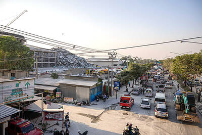
GRIDLOCK: The National Fire Agency’s Special Search and Rescue team is on standby to travel to the countries to help out with the rescue effort A powerful earthquake rocked Myanmar and neighboring Thailand yesterday, killing at least three people in Bangkok and burying dozens when a high-rise building under construction collapsed. Footage shared on social media from Myanmar’s second-largest city showed widespread destruction, raising fears that many were trapped under the rubble or killed. The magnitude 7.7 earthquake, with an epicenter near Mandalay in Myanmar, struck at midday and was followed by a strong magnitude 6.4 aftershock. The extent of death, injury and destruction — especially in Myanmar, which is embroiled in a civil war and where information is tightly controlled at the best of times —

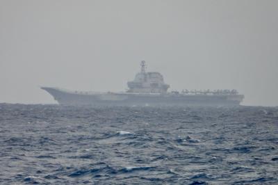
China's military today said it began joint army, navy and rocket force exercises around Taiwan to "serve as a stern warning and powerful deterrent against Taiwanese independence," calling President William Lai (賴清德) a "parasite." The exercises come after Lai called Beijing a "foreign hostile force" last month. More than 10 Chinese military ships approached close to Taiwan's 24 nautical mile (44.4km) contiguous zone this morning and Taiwan sent its own warships to respond, two senior Taiwanese officials said. Taiwan has not yet detected any live fire by the Chinese military so far, one of the officials said. The drills took place after US Secretary