With central Taiwan still struggling to recover from the damage brought by Tropical Storm Mindulle last month, meteorologists yesterday called on residents living in the northern and northeastern regions to brace themselves for more rain and wind as Typhoon Rananim moves towards Taiwan.
As of press time yesterday, the typhoon was centered at 360km east northeast of Taipei, according to the Central Weather Bureau (CWB), and heading northwest at speeds of up to 17kph.
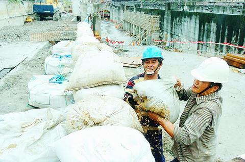
PHOTO: CHANG CHIA-MING, TAIPEI TIMES
It is expected to be 180km north northeast of Taiwan by 5pm this evening.
CWB meteorologists expect that Taiwan be affected by Rananim today and tomorrow at the very least, citing that the storm, which is currently classified as moderate in strength and impact, was just shy of being categorized as a major typhoon.
With a radius of 250km, maximum sustained winds of 140kph, and gusts of up to 175kph, the typhoon is expected to continue to gain strength according to CWB forecasts last night.
Accompanying rainfall is predicted to be especially heavy beginning early today and lasting until 5pm tonight as Typhoon Rananim continues to head northwest towards China.
By yesterday evening, the typhoon had brought 122mm of rain to Taipei County, with Taitung and Hsinchu seeing the highest levels of rainfall at 143mm of rain and 174mm respectively.
As much as 600mm of rain was expected for the northern mountainous regions yesterday night.
At 11:30am yesterday, the CWB issued land warnings for Keelung, Ilan, Taipei, Taoyuan, Hsinchu and Miaoli. The CWB also warned that vessels operating in waters off of Taiwan's north, northeast, and southeast coasts, and in the northern part of the Taiwan Strait should be on high alert against to heavy winds and rainfall.
Residents should beware of possible landslides, falling rocks, flash floods and rising water levels, as torrential rain is expected in the north, northeast and south central mountain regions, CWB meteorologists said.
Water Resources Agency director Chen Shen-hsien (陳伸賢) also said yesterday that residents should stay away from the Taipei County Hsichih portion of the Peigang River and Keelung City's Yurei Creek as breakers protecting against flooding were insufficient in the areas.
However, he played down the damage that rainfall could bring.
"Although Typhoon Rananim will bring torrential rain to Taiwan, if the rainfall is not concentrated in a short amount of time, the impact in northern Taiwan should not be overly damaging," Chen said.

SECURITY: As China is ‘reshaping’ Hong Kong’s population, Taiwan must raise the eligibility threshold for applications from Hong Kongers, Chiu Chui-cheng said When Hong Kong and Macau citizens apply for residency in Taiwan, it would be under a new category that includes a “national security observation period,” Mainland Affairs Council (MAC) Minister Chiu Chui-cheng (邱垂正) said yesterday. President William Lai (賴清德) on March 13 announced 17 strategies to counter China’s aggression toward Taiwan, including incorporating national security considerations into the review process for residency applications from Hong Kong and Macau citizens. The situation in Hong Kong is constantly changing, Chiu said to media yesterday on the sidelines of the Taipei Technology Run hosted by the Taipei Neihu Technology Park Development Association. With
A US Marine Corps regiment equipped with Naval Strike Missiles (NSM) is set to participate in the upcoming Balikatan 25 exercise in the Luzon Strait, marking the system’s first-ever deployment in the Philippines. US and Philippine officials have separately confirmed that the Navy Marine Expeditionary Ship Interdiction System (NMESIS) — the mobile launch platform for the Naval Strike Missile — would take part in the joint exercise. The missiles are being deployed to “a strategic first island chain chokepoint” in the waters between Taiwan proper and the Philippines, US-based Naval News reported. “The Luzon Strait and Bashi Channel represent a critical access

‘FORM OF PROTEST’: The German Institute Taipei said it was ‘shocked’ to see Nazi symbolism used in connection with political aims as it condemned the incident Sung Chien-liang (宋建樑), who led efforts to recall Democratic Progressive Party (DPP) Legislator Lee Kun-cheng (李坤城), was released on bail of NT$80,000 yesterday amid an outcry over a Nazi armband he wore to questioning the night before. Sung arrived at the New Taipei City District Prosecutors’ Office for questioning in a recall petition forgery case on Tuesday night wearing a red armband bearing a swastika, carrying a copy of Adolf Hitler’s Mein Kampf and giving a Nazi salute. Sung left the building at 1:15am without the armband and apparently covering the book with a coat. This is a serious international scandal and Chinese

COUNTERINTELLIGENCE TRAINING: The ministry said 87.5 percent of the apprehended Chinese agents were reported by service members they tried to lure into becoming spies Taiwanese organized crime, illegal money lenders, temples and civic groups are complicit in Beijing’s infiltration of the armed forces, the Ministry of National Defense (MND) said in a report yesterday. Retired service members who had been turned to Beijing’s cause mainly relied on those channels to infiltrate the Taiwanese military, according to the report to be submitted to lawmakers ahead of tomorrow’s hearing on Chinese espionage in the military. Chinese intelligence typically used blackmail, Internet-based communications, bribery or debts to loan sharks to leverage active service personnel to do its bidding, it said. China’s main goals are to collect intelligence, and develop a