Among the places badly affected by Typhoon Morakot in August 2009 was the popular travel destination of Rueili (瑞里) in the Alishan National Scenic Area (阿里山國家風景區). Roads surrounding the mountain settlement were left impassable, and the town’s tourist industry suffered as a result.
Two years on, the influence of Morakot can still be seen in a few places, but damaged roads have been cleared, repaired and rebuilt. Rueili’s attractions, especially its numerous trails, are once again pulling in visitors.
About 7km west of the town — at the 71km marker on County Highway 166 — you’ll find a car park and snack shop that mark the entrance for Yuantan Falls (圓潭瀑布). There are a couple of walking paths leading off from the rest area, and the one for the falls starts next to the shop. All the major walking paths in and around Rueili are clearly marked by signs in both Chinese and English.

Photo: Andrew Crosthwaite
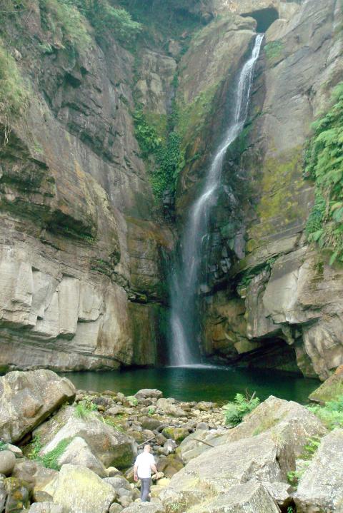
The fairly steep, 500m-long path is surrounded by a dense growth of bamboo, trees and a variety of large plants. The drone of cicadas and the presence of insects jumping and flying around you are almost constant factors throughout the warm, humid summer months. Any thoughts of feeling closed in, however, are forgotten as soon as you make your way through the vegetation and emerge into an almighty, cavernous gorge.
The opposite side of the valley is marked by a towering wall of gray stone, and massive boulders and slabs of rock litter the riverbed. The falls themselves, which are located where the two sides of the valley come together, are at their best following periods of heavy rain, when the river slaps against the rock face as it plunges down in a terrific arc of water.
THE OTHER WAY

Photo: Andrew Crosthwaite
The second pathway, which starts next to the car park’s exit, leads to a pair of rock formations called Swallow Cliff (燕子崖) and Bat Grotto (蝙蝠洞). The 2km walk takes you along an historical route called Youth Ridge Trail (青年嶺步道) that continues to Rueili. The section of the path between Swallow Cliff and Rueili Elementary School in the center of the town, however, is quite steep and at the time of writing was under repair and blocked off. For the latest news on the path’s accessibility, call the Rueitai Visitor Center at (05) 250-1070.
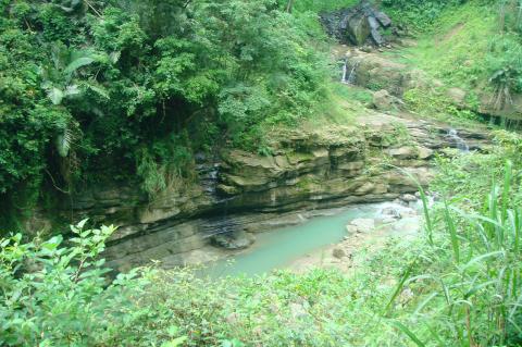
Heading off on the second path from the car park, you’re led slowly toward a river and your first view of the cliff and grotto.
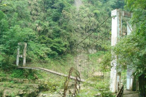
The valley here feels wonderfully remote and deserted. Vines stretch down to the riverbed from the branches of trees high on the hillside, and plants grow over the cables of a well-weathered suspension bridge.

Photo: Andrew Crosthwaite
The overall effect gives the place a lost world quality: You half expect to see pterodactyls circling the sky above you.
The 40m-wide Swallow Cliff is lined with deep grooves that used to be home to a large number of swallows’ nests. For much of the year, walking underneath it entails passing behind a curtain of water, as a stream usually flows over the cliff into the river below.
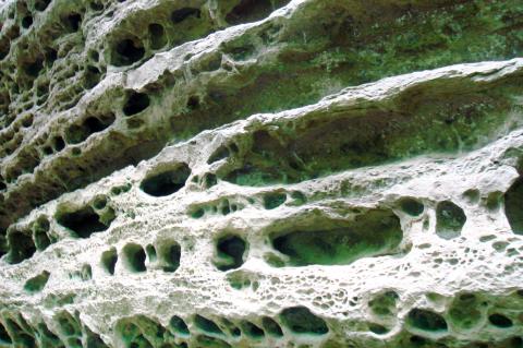
Though smaller, Bat Grotto is even more interesting as its entire surface is riddled with holes and depressions. Up close, the eroded rock resembles a wall of ancient, decaying skulls.

Photo: Andrew Crosthwaite
Half a kilometer east along County Highway 166 from the Yuantan Falls entrance — at the 71.5km marker — is the Yuantan Natural Eco Park (圓潭自然生態園區). The park was opened to the public in 2007. There’s a visitor center and cafe that overlooks a small waterfall, and there are several short walking paths. None of them are longer than a few hundred meters, and they wind their way through pleasant and well-maintained countryside toward a variety of waterfalls and a botanical garden.
It’s all nice enough, but from the obviously landscaped gardens to the freshly laid turf, there is an unmistakable feeling of newness to the park. It might take a couple of more years before it can rival Rueili’s other attractions.
Driving east toward Rueili, the one thing that stands out above all else is that the town is responsible for producing copious amounts of tea. Neat lines of tea bushes rise up the slope on one side of the road, and fall down it on the other. Rueili’s tea is reputed to be exceptionally pure and has a delicious, long-lasting sweetness that is unique to tea grown here. To taste it for yourself, just head to one of the many tea shops or producers that line the main road running through the town.

Photo: Andrew Crosthwaite
Rueili is home to a variety of firefly species, and watching the glowing little insects dance and signal to one another has become a popular activity in the town. It might rank as one of the more simple ways to spend an evening, but there’s something hypnotic and magical about seeing these tiny animal-made lights darting and weaving around in the nighttime.
Depending on the species, the fireflies emit either an orange or green light, and they can be seen most nights of the year. The best places to watch them are at Rueili Elementary School and by the Ruolan Villa (若蘭山莊), located near the 79.5km mark of the highway.
Possibly the oldest attraction in Rueili is the Rueitai Trail (瑞太步道), which dates back to the 1870s. The original path was constructed to allow goods to be transported between Rueili and Taihe (太和), and in 1931, it was replaced by an easier route to give children access to the local school.
A large section of the 80-year-old trail is still in use today, though it shouldn’t be attempted lightly. It’s a punishing up-and-down path, and while the people in the Rueitai Visitor Center might tell you that the looping round-trip will take 2 hours to complete, that’s only possible if you’re very fit. If you’re up for the challenge, though, an enjoyable walk through a tall bamboo forest awaits. The trailhead can be found at the 81km marker on County Highway 166.
Sadly, the section of the trail that leads to Taihe is closed, but this is one of only a handful of blocked paths in the area. On the whole, Rueili has recovered incredibly well from the devastation of Morakot, which is good news as this is one of the nicest places to visit in the Alishan area.
What you need to know
Getting there
Getting to Rueili is fairly easy. If you’re driving, leave Highway No. 3 at the Meishan Interchange (梅山交流道). Head into Meishan and take County Highway 162 to Taiping (太平). From there, take road 154 to Taising (太興), and then turn onto County Highway 166, which will take you all the way to Rueli.
If you’re traveling by bus, buy a ticket for Rueili at the bus station right outside the Chiayi Railway Station. The only bus in the morning leaves at 9:30am and takes you to the Meishan bus station, where you board the Rueili bus.
Where to stay
There are a few hotels and guesthouses along the main road running through the town, and there’s also a good campsite with toilets and hot showers. It’s located just off County Highway 166 at about the 75km point.
For more information, contact the Rueitai Visitor Center at the 82km marker on County Highway 166, tel: (05) 250-1070 or (05) 250-2129, or try the Yuantan Visitor Center in the Yuantan Nature Eco Park (圓潭自然生態園區), tel: (05 2502026).

In the March 9 edition of the Taipei Times a piece by Ninon Godefroy ran with the headine “The quiet, gentle rhythm of Taiwan.” It started with the line “Taiwan is a small, humble place. There is no Eiffel Tower, no pyramids — no singular attraction that draws the world’s attention.” I laughed out loud at that. This was out of no disrespect for the author or the piece, which made some interesting analogies and good points about how both Din Tai Fung’s and Taiwan Semiconductor Manufacturing Co’s (TSMC, 台積電) meticulous attention to detail and quality are not quite up to

April 21 to April 27 Hsieh Er’s (謝娥) political fortunes were rising fast after she got out of jail and joined the Chinese Nationalist Party (KMT) in December 1945. Not only did she hold key positions in various committees, she was elected the only woman on the Taipei City Council and headed to Nanjing in 1946 as the sole Taiwanese female representative to the National Constituent Assembly. With the support of first lady Soong May-ling (宋美齡), she started the Taipei Women’s Association and Taiwan Provincial Women’s Association, where she

Chinese Nationalist Party (KMT) Chairman Eric Chu (朱立倫) hatched a bold plan to charge forward and seize the initiative when he held a protest in front of the Taipei City Prosecutors’ Office. Though risky, because illegal, its success would help tackle at least six problems facing both himself and the KMT. What he did not see coming was Taipei Mayor Chiang Wan-an (將萬安) tripping him up out of the gate. In spite of Chu being the most consequential and successful KMT chairman since the early 2010s — arguably saving the party from financial ruin and restoring its electoral viability —

It is one of the more remarkable facts of Taiwan history that it was never occupied or claimed by any of the numerous kingdoms of southern China — Han or otherwise — that lay just across the water from it. None of their brilliant ministers ever discovered that Taiwan was a “core interest” of the state whose annexation was “inevitable.” As Paul Kua notes in an excellent monograph laying out how the Portuguese gave Taiwan the name “Formosa,” the first Europeans to express an interest in occupying Taiwan were the Spanish. Tonio Andrade in his seminal work, How Taiwan Became Chinese,