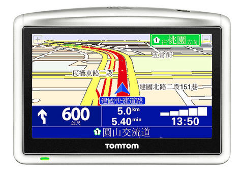
The in-car GPS system is without doubt one of the "it" gadgets of the moment, and they will be gracing many a Christmas tree come December. With its wealth of experience in building small electronic devices combining touch screens and wireless technologies, Taiwan was bound to pick up on the trend. Here is a look at how two Taiwanese brands compare to Netherlands-based TomTom, the global leader in GPS devices.
As soon as the packaging is opened, the ONE XL exudes confidence with its simple and sturdy construction. The only physical switch, on the top of the unit, is the power button; all other interaction is handled on the touch screen with a series of gestures and swipes that is both fun and intuitive. Details include the small brow on the top edge of the screen that helps block glare from the sun and provides a useful grip when sliding it into the docking mount.
The accessories that are included with the unit are also of higher-than-average quality. ONE XL gets top marks for the window mount that doesn't look like an architectural joist - it's good-looking enough to leave in place and small enough to safely stow away in the glove box.

In use, the software is clear and precise, though, like any navigation system, it is prone to occasional quirky routes with hilarious comic timing such as the voice thoughtfully directing the driver to turn around on a busy six-lane highway. Passengers also became highly alarmed when what sounded like a steam train barreling down Zhongxiao Road straight at the car turned out to be the auditory warning of an approaching speed camera.
Those considering the ONE XL may well want to look further down the product range. The ONE device lacks the 4.3 inch screen display and some of the features of its more expensive brethren, but the compact dimensions may be a plus for drivers with cramped interiors. Those who do want the extra screen real estate may want to wait for the GO 720 that will be launched this month sporting, among other things, voice control.
Mitac is the premier Taiwanese manufacturer of GPS devices and has many years of experience in the field. The Mio C720T is one of the latest GPS systems and has a couple of features that make it special.
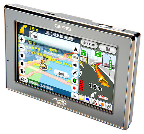
The first of these is a 2 megapixel digital camera on the back of the device. This allows you to take a photo of a business card and use this as the destination of the journey. It's a great idea, but in reality the performance was less than perfect, and it was often quicker to manually enter the address. The other interesting feature was combining the photo with "geo-tagged" information - tracking the location of each photo. It's a fantastic addition, but there needs to a be a little more development work on the services side.
The design is much more angular than the subtler TomTom. Although it had a decent 4.3 inch screen, the chrome detailing meant that on sunny days glare became a problem, and at nighttime the row of LEDs became a little distracting.
Accessories-wise, the window mount is a little bulky and includes multiple screw adjustments for alignment and angle, and it allows you to leave the power plugged in to the dock when the device is removed. Unlike the TomTom, a mains power adaptor is included for charging at home.
The user interface is not as polished as the TomTom and certainly requires a little more learning as a result.
The Acer c500 takes a slightly different approach from the dedicated unit. In this case, the company employs a Microsoft Windows PDA and uses the included Papago software and GPS antenna to do the work. The styling is pretty neat, and it is certainly small enough to stow away in a purse or bag, with the obvious advantage of being able to run other software on top of the navigation functions. As ever, there are trade-offs to be had between small size and large display.
The downside of multi-functions is that the device is not quite so good at pure navigation, and forgoes the touch screen interaction in favor of stylus-led input. This is all very well when sitting at home planning the route, but mid-journey adjustment becomes more difficult when poking around with a stick on the small 2.8 inch screen. However, Papago is arguably the most highly developed mapping software for Taiwan, and it is likely to pick up on many of the charming intricacies of the road system.
The rapid growth of smart phones has, no doubt, squeezed the PDA market a great deal. As a result, for a little more money, it is possible to get a similarly-sized device that can also place phone calls. For those migrating from PDAs without GPS functionality, however, this would be a very handy upgrade.
Regardless of which device you choose, the next generation will carry not memories of parents battling with maps and road signs, but with an inanimate bit of plastic.
Jonathan Biddle is head of Industrial Design at DEM INC
In the March 9 edition of the Taipei Times a piece by Ninon Godefroy ran with the headine “The quiet, gentle rhythm of Taiwan.” It started with the line “Taiwan is a small, humble place. There is no Eiffel Tower, no pyramids — no singular attraction that draws the world’s attention.” I laughed out loud at that. This was out of no disrespect for the author or the piece, which made some interesting analogies and good points about how both Din Tai Fung’s and Taiwan Semiconductor Manufacturing Co’s (TSMC, 台積電) meticulous attention to detail and quality are not quite up to

April 21 to April 27 Hsieh Er’s (謝娥) political fortunes were rising fast after she got out of jail and joined the Chinese Nationalist Party (KMT) in December 1945. Not only did she hold key positions in various committees, she was elected the only woman on the Taipei City Council and headed to Nanjing in 1946 as the sole Taiwanese female representative to the National Constituent Assembly. With the support of first lady Soong May-ling (宋美齡), she started the Taipei Women’s Association and Taiwan Provincial Women’s Association, where she

Chinese Nationalist Party (KMT) Chairman Eric Chu (朱立倫) hatched a bold plan to charge forward and seize the initiative when he held a protest in front of the Taipei City Prosecutors’ Office. Though risky, because illegal, its success would help tackle at least six problems facing both himself and the KMT. What he did not see coming was Taipei Mayor Chiang Wan-an (將萬安) tripping him up out of the gate. In spite of Chu being the most consequential and successful KMT chairman since the early 2010s — arguably saving the party from financial ruin and restoring its electoral viability —
It is one of the more remarkable facts of Taiwan history that it was never occupied or claimed by any of the numerous kingdoms of southern China — Han or otherwise — that lay just across the water from it. None of their brilliant ministers ever discovered that Taiwan was a “core interest” of the state whose annexation was “inevitable.” As Paul Kua notes in an excellent monograph laying out how the Portuguese gave Taiwan the name “Formosa,” the first Europeans to express an interest in occupying Taiwan were the Spanish. Tonio Andrade in his seminal work, How Taiwan Became Chinese,